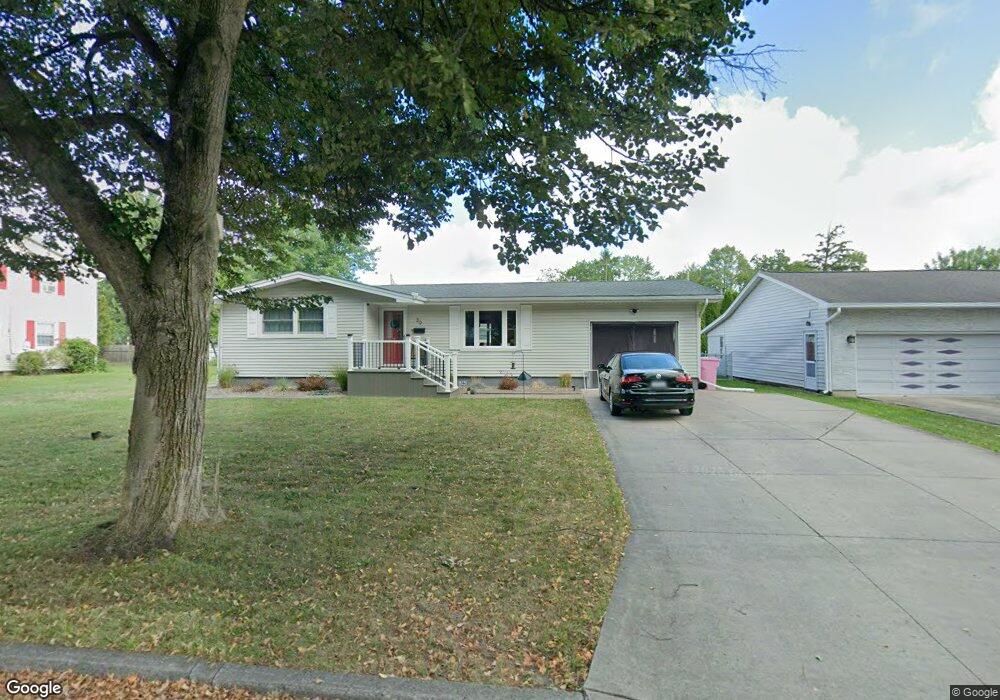
39 Vermont Ave Lockport, NY 14094
Estimated Value: $205,000 - $229,000
3
Beds
1
Bath
1,026
Sq Ft
$207/Sq Ft
Est. Value
About This Home
This home is located at 39 Vermont Ave, Lockport, NY 14094 and is currently estimated at $212,807, approximately $207 per square foot. 39 Vermont Ave is a home located in Niagara County with nearby schools including Aaron Mossell Junior High School, Lockport High School, and DeSales Catholic School.
Ownership History
Date
Name
Owned For
Owner Type
Purchase Details
Closed on
Dec 2, 2010
Sold by
Lathbury Randy B and Lathbury Randy
Bought by
Lathbury Randy B and Lathbury Jennifer L
Current Estimated Value
Home Financials for this Owner
Home Financials are based on the most recent Mortgage that was taken out on this home.
Original Mortgage
$2,886
Outstanding Balance
$65
Interest Rate
4.23%
Mortgage Type
New Conventional
Estimated Equity
$212,742
Purchase Details
Closed on
Oct 27, 2006
Sold by
Ward Randal
Bought by
Lathbury Randy
Home Financials for this Owner
Home Financials are based on the most recent Mortgage that was taken out on this home.
Original Mortgage
$92,881
Outstanding Balance
$55,248
Interest Rate
6.31%
Mortgage Type
FHA
Estimated Equity
$157,559
Create a Home Valuation Report for This Property
The Home Valuation Report is an in-depth analysis detailing your home's value as well as a comparison with similar homes in the area
Home Values in the Area
Average Home Value in this Area
Purchase History
| Date | Buyer | Sale Price | Title Company |
|---|---|---|---|
| Lathbury Randy B | -- | None Available | |
| Lathbury Randy | $94,340 | Jon Louis Wilson |
Source: Public Records
Mortgage History
| Date | Status | Borrower | Loan Amount |
|---|---|---|---|
| Open | Lathbury Randy B | $2,886 | |
| Open | Lathbury Randy | $92,881 |
Source: Public Records
Tax History Compared to Growth
Tax History
| Year | Tax Paid | Tax Assessment Tax Assessment Total Assessment is a certain percentage of the fair market value that is determined by local assessors to be the total taxable value of land and additions on the property. | Land | Improvement |
|---|---|---|---|---|
| 2024 | $3,348 | $141,000 | $10,500 | $130,500 |
| 2023 | $3,193 | $132,000 | $10,500 | $121,500 |
| 2022 | $2,438 | $118,000 | $10,500 | $107,500 |
| 2021 | $2,954 | $90,800 | $9,100 | $81,700 |
| 2020 | $2,806 | $90,800 | $9,100 | $81,700 |
| 2019 | $785 | $90,800 | $9,100 | $81,700 |
| 2018 | $1,816 | $90,800 | $9,100 | $81,700 |
| 2017 | $1,786 | $90,800 | $9,100 | $81,700 |
| 2016 | $1,678 | $90,800 | $9,100 | $81,700 |
| 2015 | -- | $90,800 | $9,100 | $81,700 |
| 2014 | -- | $90,800 | $9,100 | $81,700 |
Source: Public Records
Map
Nearby Homes
- 40 Georgia Ave
- 869 Lincoln Ave
- 178 Continental Dr
- 76 Morrow Ave
- 544 Willow St
- 60 Morrow Ave
- 206 Continental Dr
- 144 Grant St
- 105 Obrien Dr
- 27 Independence Dr
- 529 Willow St
- 45 Morrow Ave
- 44 Coolidge Ave
- 151 Independence Dr
- 546 High St
- 465 Washburn St
- 0 Beattie Ave
- 411 Washburn St
- 76 Elizabeth Dr
- 20 Park Lane Cir
- 35 Vermont Ave
- 45 Vermont Ave
- 40 Pennsylvania Ave
- 42 Pennsylvania Ave
- 38 Pennsylvania Ave
- 40 Vermont Ave
- 122 Vermont Ave
- 33 Vermont Ave
- 36 Vermont Ave
- 50 Pennsylvania Ave
- 124 Vermont Ave
- 32 Vermont Ave
- 29 Vermont Ave
- 43 Pennsylvania Ave
- 37 Carolina Ave
- 47 Pennsylvania Ave
- 33 Carolina Ave
- 30 Pennsylvania Ave
- 55 Vermont Ave
- 37 Pennsylvania Ave