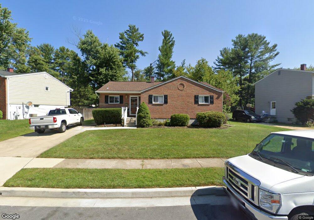
3905 Bryony Rd Randallstown, MD 21133
Estimated Value: $299,000 - $422,000
--
Bed
2
Baths
1,491
Sq Ft
$256/Sq Ft
Est. Value
About This Home
This home is located at 3905 Bryony Rd, Randallstown, MD 21133 and is currently estimated at $381,947, approximately $256 per square foot. 3905 Bryony Rd is a home located in Baltimore County with nearby schools including Randallstown Elementary School, Deer Park Middle Magnet School, and Randallstown High School.
Ownership History
Date
Name
Owned For
Owner Type
Purchase Details
Closed on
Dec 23, 2003
Sold by
Secretary Of Housing
Bought by
Garcia Yanixa
Current Estimated Value
Purchase Details
Closed on
May 23, 2003
Sold by
Baldwin Ernestine L
Bought by
Secretary Of Housing
Purchase Details
Closed on
May 13, 2002
Sold by
Baldwin Foster D
Bought by
Baldwin Ernestine L and Michelle Baldwin
Purchase Details
Closed on
Mar 11, 1998
Sold by
Bankers Trust Company/Trustee
Bought by
Baldwin Foster D and Baldwin Ernestine L
Purchase Details
Closed on
Dec 19, 1996
Sold by
Fonrose Aldwyn
Bought by
Bankers Trust Company/Trustee
Create a Home Valuation Report for This Property
The Home Valuation Report is an in-depth analysis detailing your home's value as well as a comparison with similar homes in the area
Home Values in the Area
Average Home Value in this Area
Purchase History
| Date | Buyer | Sale Price | Title Company |
|---|---|---|---|
| Garcia Yanixa | $130,000 | -- | |
| Secretary Of Housing | $117,494 | -- | |
| Baldwin Ernestine L | -- | -- | |
| Baldwin Foster D | $103,400 | -- | |
| Bankers Trust Company/Trustee | $70,000 | -- |
Source: Public Records
Tax History Compared to Growth
Tax History
| Year | Tax Paid | Tax Assessment Tax Assessment Total Assessment is a certain percentage of the fair market value that is determined by local assessors to be the total taxable value of land and additions on the property. | Land | Improvement |
|---|---|---|---|---|
| 2025 | $5,052 | $285,233 | -- | -- |
| 2024 | $5,052 | $266,000 | $74,000 | $192,000 |
| 2023 | $2,341 | $253,467 | $0 | $0 |
| 2022 | $4,687 | $240,933 | $0 | $0 |
| 2021 | $7,446 | $228,400 | $56,000 | $172,400 |
| 2020 | $7,446 | $227,533 | $0 | $0 |
| 2019 | $3,597 | $226,667 | $0 | $0 |
| 2018 | $3,570 | $225,800 | $56,000 | $169,800 |
| 2017 | $3,462 | $203,900 | $0 | $0 |
| 2016 | $2,777 | $182,000 | $0 | $0 |
| 2015 | $2,777 | $160,100 | $0 | $0 |
| 2014 | $2,777 | $160,100 | $0 | $0 |
Source: Public Records
Map
Nearby Homes
- 9044 Allenswood Rd
- 3854 Terka Cir
- 8908 Meadow Heights Rd
- 3805 Terka Cir
- 3907 Roxanne Rd
- 20 Sunrise Ct
- 9012 Allenswood Rd
- 28 Sunrise Ct
- 3705 Allenswood Ct
- 1205/99 Winands Rd
- 3816 Cassandra Rd
- 9112 Meadow Heights Rd
- 8806 Gilly Way Unit D
- 8802 Falcon Ridge Dr
- 4105 Kiwi Ct
- 9202 Samoset Rd
- 4135 Brookside Oaks
- 4228 Brookside Oaks
- 3506 Bayer Ave
- 20 Windy Meadow Ct