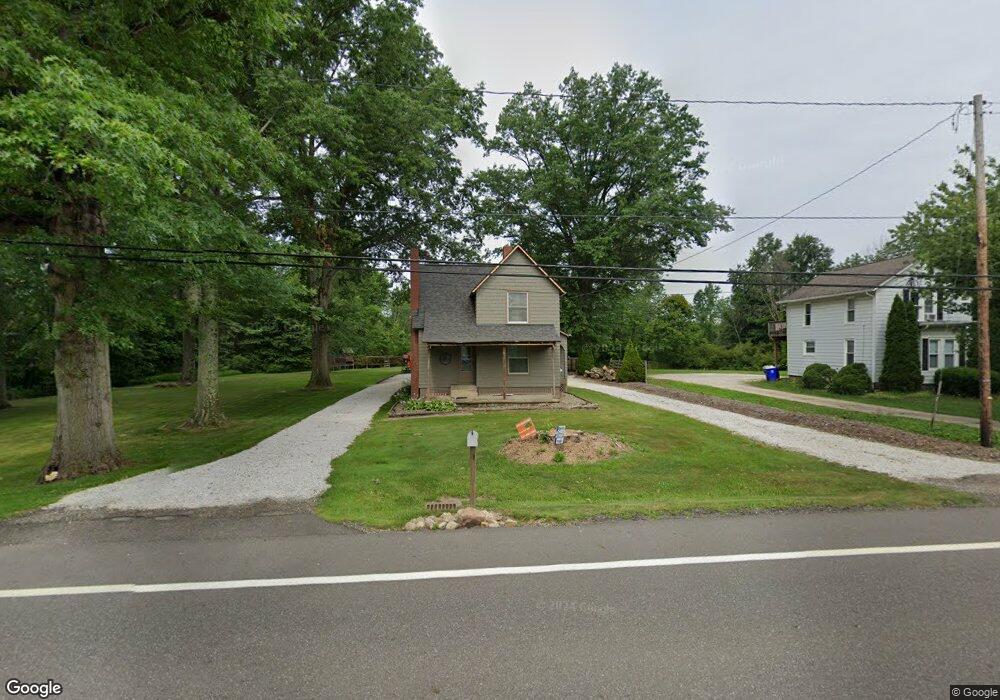
3905 State Route 44 Rootstown, OH 44272
Estimated Value: $175,000 - $243,000
3
Beds
1
Bath
1,400
Sq Ft
$157/Sq Ft
Est. Value
About This Home
This home is located at 3905 State Route 44, Rootstown, OH 44272 and is currently estimated at $219,899, approximately $157 per square foot. 3905 State Route 44 is a home located in Portage County with nearby schools including Rootstown Middle School - Schnee Building and Rootstown High School.
Ownership History
Date
Name
Owned For
Owner Type
Purchase Details
Closed on
Mar 19, 2004
Sold by
Moore Douglas S and Moore David J
Bought by
Horning Jason R
Current Estimated Value
Home Financials for this Owner
Home Financials are based on the most recent Mortgage that was taken out on this home.
Original Mortgage
$114,000
Outstanding Balance
$63,060
Interest Rate
8.37%
Mortgage Type
Purchase Money Mortgage
Estimated Equity
$156,839
Purchase Details
Closed on
Mar 21, 2003
Sold by
Sue Michael Kennethea and Sue Kennethea
Bought by
Moore Douglas S and Moore David J
Purchase Details
Closed on
Jun 26, 1991
Bought by
Michael Kennethea Sue
Create a Home Valuation Report for This Property
The Home Valuation Report is an in-depth analysis detailing your home's value as well as a comparison with similar homes in the area
Purchase History
| Date | Buyer | Sale Price | Title Company |
|---|---|---|---|
| Horning Jason R | $112,500 | Approved Statewide Title Age | |
| Moore Douglas S | $70,000 | -- | |
| Michael Kennethea Sue | $52,500 | -- |
Source: Public Records
Mortgage History
| Date | Status | Borrower | Loan Amount |
|---|---|---|---|
| Open | Horning Jason R | $114,000 |
Source: Public Records
Tax History
| Year | Tax Paid | Tax Assessment Tax Assessment Total Assessment is a certain percentage of the fair market value that is determined by local assessors to be the total taxable value of land and additions on the property. | Land | Improvement |
|---|---|---|---|---|
| 2024 | $3,018 | $75,050 | $19,570 | $55,480 |
| 2023 | $3,046 | $59,890 | $17,220 | $42,670 |
| 2022 | $2,980 | $59,890 | $17,220 | $42,670 |
| 2021 | $2,671 | $59,890 | $17,220 | $42,670 |
| 2020 | $2,765 | $52,580 | $16,420 | $36,160 |
| 2019 | $2,784 | $52,580 | $16,420 | $36,160 |
| 2017 | $2,276 | $46,450 | $19,640 | $26,810 |
| 2016 | $2,326 | $46,450 | $19,640 | $26,810 |
Source: Public Records
Map
Nearby Homes
- 4079 Siefer Dr
- 3701 State Route 44
- 3689 Cherry Hill
- 0 Lynn Rd Unit 5110102
- V/L 2 Lynn Rd
- V/L Lynn Rd
- 4415 Farmette Dr
- 4225 Hattrick Rd
- 4691 Scenic Dr
- sub lot Lane Ave
- 3637 Old Forge Rd
- 4556 Rootstown Rd
- 3021 Hartville Rd
- 0 Tallmadge Rd Unit 5189301
- 0 Tallmadge Rd Unit 5189314
- 4140 Sandy Lake Rd
- 4058 Bayberry Knoll Ln
- 3925 Summit Rd
- 3080 Saxe Rd
- 4958 Bassett Rd
- 3915 State Route 44
- 3937 State Route 44
- 3902 State Route 44
- 3916 State Route 44
- 3873 State Route 44
- 3932 State Route 44
- 3947 State Route 44
- 3955 State Route 44
- 3959 State Route 44
- 3944 State Route 44
- 3969 State Route 44
- 3958 State Route 44
- v-l 22 Ohio 44
- 3979 State Route 44
- 3972 State Route 44
- 3949 Cook Rd
- 3987 State Route 44
- 3937 Cook Rd
- 3830 State Route 44
- 3995 State Route 44
Your Personal Tour Guide
Ask me questions while you tour the home.