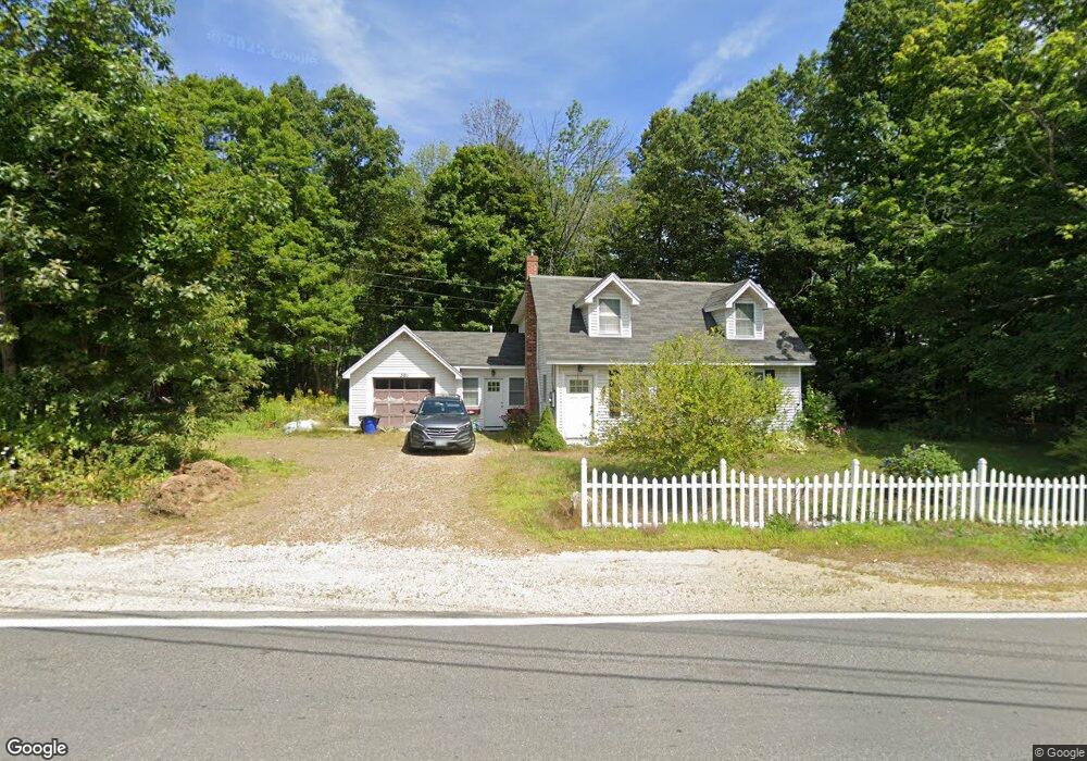
391 Governor Wentworth Hwy Moultonborough, NH 03254
Estimated Value: $480,184 - $547,000
3
Beds
2
Baths
1,639
Sq Ft
$317/Sq Ft
Est. Value
About This Home
This home is located at 391 Governor Wentworth Hwy, Moultonborough, NH 03254 and is currently estimated at $520,046, approximately $317 per square foot. 391 Governor Wentworth Hwy is a home located in Carroll County with nearby schools including Moultonborough Central School and Moultonborough Academy High School.
Ownership History
Date
Name
Owned For
Owner Type
Purchase Details
Closed on
Dec 22, 2017
Sold by
Dow William F and Dow Elizabeth B
Bought by
Dodier Dennis F and Dodier Susan L
Current Estimated Value
Home Financials for this Owner
Home Financials are based on the most recent Mortgage that was taken out on this home.
Original Mortgage
$102,767
Outstanding Balance
$87,250
Interest Rate
3.9%
Mortgage Type
FHA
Estimated Equity
$432,797
Purchase Details
Closed on
Nov 14, 2005
Sold by
Ditullio Louise M
Bought by
Acld Rt
Create a Home Valuation Report for This Property
The Home Valuation Report is an in-depth analysis detailing your home's value as well as a comparison with similar homes in the area
Home Values in the Area
Average Home Value in this Area
Purchase History
| Date | Buyer | Sale Price | Title Company |
|---|---|---|---|
| Dodier Dennis F | $210,000 | -- | |
| Acld Rt | $1,700 | -- |
Source: Public Records
Mortgage History
| Date | Status | Borrower | Loan Amount |
|---|---|---|---|
| Open | Dodier Dennis F | $102,767 |
Source: Public Records
Tax History Compared to Growth
Tax History
| Year | Tax Paid | Tax Assessment Tax Assessment Total Assessment is a certain percentage of the fair market value that is determined by local assessors to be the total taxable value of land and additions on the property. | Land | Improvement |
|---|---|---|---|---|
| 2024 | $1,931 | $341,700 | $94,000 | $247,700 |
| 2023 | $1,823 | $319,900 | $75,000 | $244,900 |
| 2022 | $1,381 | $289,000 | $67,500 | $221,500 |
| 2021 | $1,661 | $237,900 | $49,900 | $188,000 |
| 2020 | $1,586 | $222,500 | $49,900 | $172,600 |
| 2019 | $1,390 | $194,400 | $49,900 | $144,500 |
| 2018 | $1,479 | $191,600 | $49,900 | $141,700 |
| 2017 | $1,514 | $184,200 | $49,900 | $134,300 |
| 2016 | $1,513 | $173,100 | $49,900 | $123,200 |
| 2015 | $1,455 | $161,500 | $49,900 | $111,600 |
| 2014 | $1,341 | $151,400 | $49,900 | $101,500 |
| 2013 | $1,316 | $151,400 | $49,900 | $101,500 |
Source: Public Records
Map
Nearby Homes
- 42 Farm Rd
- 538 Governor Wentworth Hwy
- 27 Meadow Glen Dr
- 66 Hayes Ln
- 37 Mayflower Ln
- 24 Sunrise Dr
- 0 States Landing Rd Unit 5036165
- 120 Locarno St
- 7 Eden Ln
- 122-1 Gwh Hwy
- 31 Suissevale Ave
- 11 Harriet Ln
- 17 Whitehouse Farm Ln
- 00 Sundorf St Unit 117
- 0 Sundorf St Unit 901 5009559
- 107 Governor Wentworth Hwy
- 72 Sundorf St
- 122-001-002 Governor Wentworth Hwy
- 88 Suissevale Ave
- 284 Ossipee Mountain Rd
- 391 Gov Wentworth Hwy
- 0 Governor Wentworth Hwy Unit 4892649
- 0 Governor Wentworth Hwy
- 381 Governor Wentworth Hwy
- 369 Gov Wentworth Hwy
- 369 Governor Wentworth Hwy
- 0 Yukon Trail
- 16 Paradise Dr
- 362 Governor Wentworth Hwy
- 402 Governor Wentworth Hwy
- 354 Governor Wentworth Hwy
- 419 Governor Wentworth Hwy
- 354 Govenor Wentworth Hwy
- 204 Yukon Trail
- 40-42 Yukon Trail
- 33 Paradise Dr
- 420 Governor Wentworth Hwy
- 42 Paradise Dr
- 442 Governor Wentworth Hwy
- 338 Governor Wentworth Hwy