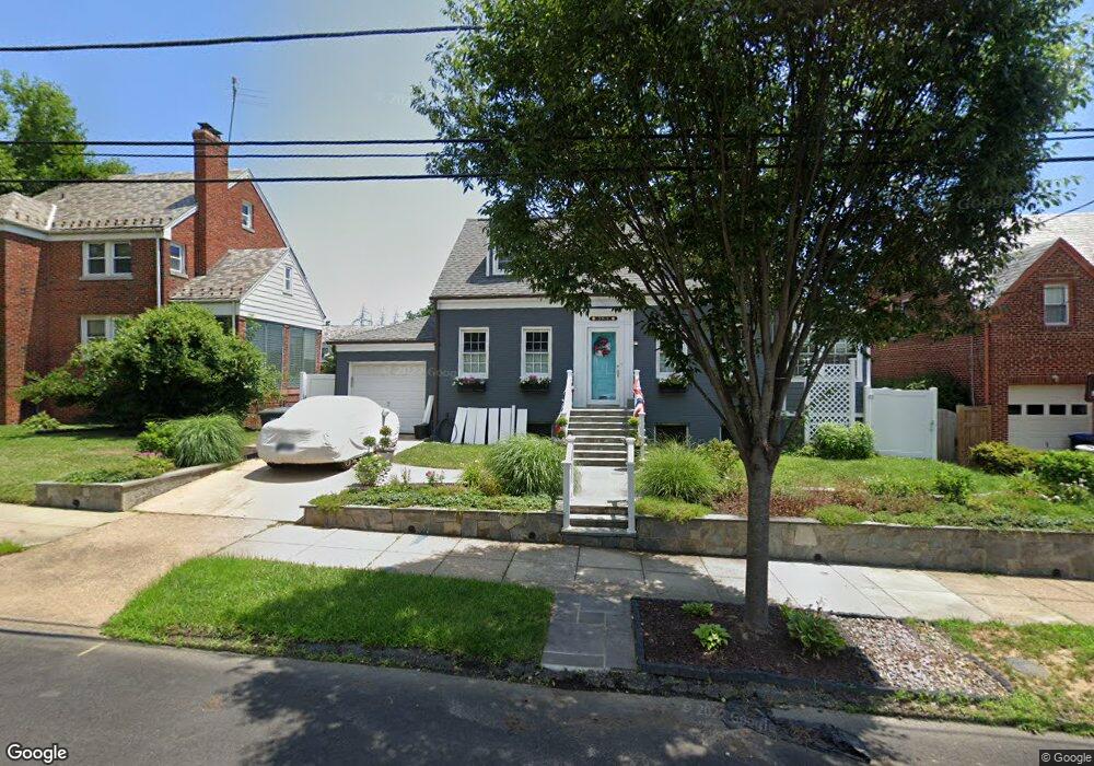
3915 17th St NE Washington, DC 20018
Brookland NeighborhoodEstimated Value: $742,000 - $854,250
3
Beds
3
Baths
1,560
Sq Ft
$520/Sq Ft
Est. Value
About This Home
This home is located at 3915 17th St NE, Washington, DC 20018 and is currently estimated at $811,083, approximately $519 per square foot. 3915 17th St NE is a home located in District of Columbia with nearby schools including Burroughs Education Campus, Brookland Middle School, and Dunbar High School.
Ownership History
Date
Name
Owned For
Owner Type
Purchase Details
Closed on
Jun 23, 2010
Sold by
Moultrie H Carl
Bought by
Giblin Robert A
Current Estimated Value
Home Financials for this Owner
Home Financials are based on the most recent Mortgage that was taken out on this home.
Original Mortgage
$380,000
Outstanding Balance
$251,307
Interest Rate
4.78%
Mortgage Type
New Conventional
Estimated Equity
$559,776
Create a Home Valuation Report for This Property
The Home Valuation Report is an in-depth analysis detailing your home's value as well as a comparison with similar homes in the area
Home Values in the Area
Average Home Value in this Area
Purchase History
| Date | Buyer | Sale Price | Title Company |
|---|---|---|---|
| Giblin Robert A | $399,999 | -- |
Source: Public Records
Mortgage History
| Date | Status | Borrower | Loan Amount |
|---|---|---|---|
| Open | Giblin Robert A | $380,000 |
Source: Public Records
Tax History
| Year | Tax Paid | Tax Assessment Tax Assessment Total Assessment is a certain percentage of the fair market value that is determined by local assessors to be the total taxable value of land and additions on the property. | Land | Improvement |
|---|---|---|---|---|
| 2025 | $6,350 | $836,920 | $421,490 | $415,430 |
| 2024 | $6,094 | $804,040 | $408,530 | $395,510 |
| 2023 | $5,722 | $766,300 | $398,450 | $367,850 |
| 2022 | $5,246 | $695,930 | $353,760 | $342,170 |
| 2021 | $5,046 | $669,970 | $348,530 | $321,440 |
| 2020 | $4,840 | $645,080 | $333,220 | $311,860 |
| 2019 | $4,542 | $625,140 | $315,360 | $309,780 |
| 2017 | $3,772 | $596,950 | $0 | $0 |
| 2016 | $3,434 | $527,800 | $0 | $0 |
Source: Public Records
Map
Nearby Homes
- 3918 17th Place NE
- 3914 18th St NE
- 1714 Otis St NE
- 1719 Taylor St NE
- 0 Vacant Lot 0031 20th Aly NE
- 0 Vacant Lot 0804 20th Aly NE Unit DCDC2222260
- 0 Vacant Lot 0028 20th Aly NE
- 1822 Taylor St NE
- 1828 Newton St NE
- 3512 18th St NE
- 4100 20th St NE
- 3511 15th St NE
- 4016 21st St NE
- 2017 Perry St NE
- 1358 Newton St NE
- 1811 Lawrence St NE
- 3314 16th St NE
- 1241 Perry St NE
- 2201 Taylor St NE
- 2222 Otis St NE
- 3919 17th St NE
- 3912 17th Place NE
- 3906 17th Place NE
- 3905 17th St NE
- 3900 17th Place NE
- 3916 17th St NE
- 3923 17th St NE
- 3912 17th St NE
- 3920 17th St NE
- 1707 Randolph St NE Unit 1707 Randolph Street
- 1707 Randolph St NE
- 3908 17th St NE
- 3926 17th Place NE
- 3924 17th St NE
- 3901 17th St NE
- 3904 17th St NE
- 3832 17th Place NE
- 3928 17th St NE
- 3900 17th St NE
- 3913 17th Place NE
Your Personal Tour Guide
Ask me questions while you tour the home.