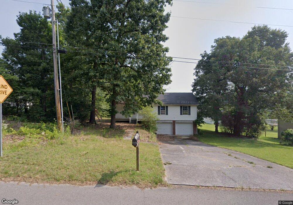
392 Patty Rd Ringgold, GA 30736
Beaumont NeighborhoodEstimated Value: $207,852 - $252,000
Studio
2
Baths
1,144
Sq Ft
$208/Sq Ft
Est. Value
About This Home
This home is located at 392 Patty Rd, Ringgold, GA 30736 and is currently estimated at $237,963, approximately $208 per square foot. 392 Patty Rd is a home located in Catoosa County with nearby schools including Woodstation Elementary School, Heritage Middle School, and Heritage High School.
Ownership History
Date
Name
Owned For
Owner Type
Purchase Details
Closed on
Jun 21, 2019
Sold by
Bolden Nancy B
Bought by
Henderson Tammy L
Current Estimated Value
Purchase Details
Closed on
Jul 1, 1996
Sold by
Associats Inc A and Associats Associats,Inc W
Bought by
Henderson Tammy and Henderson Bolden
Purchase Details
Closed on
Apr 17, 1996
Bought by
Associates Inc A and Associates Associates,Inc W
Create a Home Valuation Report for This Property
The Home Valuation Report is an in-depth analysis detailing your home's value as well as a comparison with similar homes in the area
Home Values in the Area
Average Home Value in this Area
Purchase History
| Date | Buyer | Sale Price | Title Company |
|---|---|---|---|
| Henderson Tammy L | -- | -- | |
| Henderson Tammy | $13,000 | -- | |
| Associates Inc A | -- | -- |
Source: Public Records
Tax History
| Year | Tax Paid | Tax Assessment Tax Assessment Total Assessment is a certain percentage of the fair market value that is determined by local assessors to be the total taxable value of land and additions on the property. | Land | Improvement |
|---|---|---|---|---|
| 2025 | $1,378 | $77,444 | $10,000 | $67,444 |
| 2024 | $1,591 | $74,593 | $10,000 | $64,593 |
| 2023 | $1,235 | $57,900 | $10,000 | $47,900 |
| 2022 | $1,021 | $47,583 | $10,000 | $37,583 |
| 2021 | $565 | $29,003 | $10,000 | $19,003 |
| 2020 | $609 | $26,318 | $10,000 | $16,318 |
| 2019 | $366 | $17,636 | $10,000 | $7,636 |
| 2018 | $411 | $16,636 | $9,000 | $7,636 |
| 2017 | $1,036 | $43,924 | $9,000 | $34,924 |
| 2016 | $1,009 | $40,824 | $9,000 | $31,824 |
| 2015 | -- | $40,824 | $9,000 | $31,824 |
| 2014 | -- | $40,824 | $9,000 | $31,824 |
| 2013 | -- | $40,824 | $9,000 | $31,824 |
Source: Public Records
Map
Nearby Homes
- 25 Golden Pond Ln
- 391 Oak Tree Rd
- 428 Dodd Rd
- 478 Dedmon Rd
- 713 Mount Pisgah Rd
- 56 Ginger Dr
- 486 E Sharon Cir
- 156 Bent Tree Dr
- 8 E Sharon Cir
- 81 Shrader Ln
- 2578 Poplar Springs Rd
- 417 Davis Ridge Rd
- 235 Potts Rd
- 141 Harbour Ln
- 0 Alabama Hwy Unit 10586300
- 0 Alabama Hwy Unit 1518818
- 63 Sunset Dr
- 15 Windy Hill Dr
- 3262 Poplar Springs Rd
- 3785 Poplar Springs Rd
Your Personal Tour Guide
Ask me questions while you tour the home.