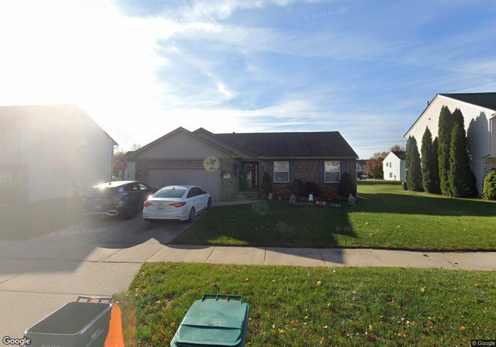
39201 Commons Dr Romulus, MI 48174
Estimated Value: $282,884 - $336,000
3
Beds
2
Baths
1,450
Sq Ft
$217/Sq Ft
Est. Value
About This Home
This home is located at 39201 Commons Dr, Romulus, MI 48174 and is currently estimated at $314,721, approximately $217 per square foot. 39201 Commons Dr is a home located in Wayne County with nearby schools including Wick Elementary School, Romulus Middle School, and Romulus Senior High School.
Ownership History
Date
Name
Owned For
Owner Type
Purchase Details
Closed on
Sep 20, 2011
Sold by
Fannie Mae
Bought by
Hampton James
Current Estimated Value
Purchase Details
Closed on
Nov 4, 2010
Sold by
Wells Fargo Bank Na
Bought by
Federal National Mortgage Association
Purchase Details
Closed on
Nov 3, 2010
Sold by
Williams Roderick K
Bought by
Wells Fargo Bank Na
Create a Home Valuation Report for This Property
The Home Valuation Report is an in-depth analysis detailing your home's value as well as a comparison with similar homes in the area
Home Values in the Area
Average Home Value in this Area
Purchase History
| Date | Buyer | Sale Price | Title Company |
|---|---|---|---|
| Hampton James | $84,000 | Attorneys Title Agency Llc | |
| Federal National Mortgage Association | -- | None Available | |
| Wells Fargo Bank Na | $195,978 | None Available |
Source: Public Records
Tax History
| Year | Tax Paid | Tax Assessment Tax Assessment Total Assessment is a certain percentage of the fair market value that is determined by local assessors to be the total taxable value of land and additions on the property. | Land | Improvement |
|---|---|---|---|---|
| 2025 | $2,552 | $135,300 | $0 | $0 |
| 2024 | $2,565 | $136,300 | $0 | $0 |
| 2023 | $2,461 | $123,800 | $0 | $0 |
| 2022 | $2,914 | $101,200 | $0 | $0 |
| 2021 | $2,824 | $88,900 | $0 | $0 |
| 2020 | $2,767 | $84,700 | $0 | $0 |
| 2019 | $2,697 | $73,100 | $0 | $0 |
| 2018 | $1,755 | $64,600 | $0 | $0 |
| 2017 | $1,322 | $64,000 | $0 | $0 |
| 2016 | $2,328 | $65,000 | $0 | $0 |
| 2015 | $4,583 | $53,100 | $0 | $0 |
| 2013 | $4,440 | $48,500 | $0 | $0 |
| 2012 | $1,341 | $47,000 | $4,700 | $42,300 |
Source: Public Records
Map
Nearby Homes
- 39025 Buckingham Dr
- 9069 Heritage Dr
- 7065 El Paso Blvd
- 0 Hannan Rd Unit 20261000615
- 11630 Ozga St
- 7175 Ozga St
- 37207 Ecorse Rd
- 6887 Haggerty Rd
- 7047 Haggerty Rd
- 10401 Ozga St
- 9828 Barkley St
- 36617 Herman St
- 40065 Interstate 94 S Service Dr
- 35773 Surrey Ct
- 9722 Hamilton St
- 36227 Vinewood St
- 36850 Perry St
- 000 Waynecorse
- 8080 Wayne Rd
- 35945 Herman St
- 39179 Commons Dr
- 39223 Commons Dr
- 39216 Nottingham Dr
- 39165 Commons Dr
- 39238 Nottingham Dr
- 39245 Commons Dr
- 39194 Nottingham Dr
- 39200 Commons Dr
- 39260 Nottingham Dr
- 39222 Commons Dr
- 39178 Commons Dr
- 39153 Commons Dr
- 39267 Commons Dr
- 39244 Commons Dr
- 39166 Commons Dr
- 39282 Nottingham Dr
- 39172 Nottingham Dr
- 39266 Commons Dr
- 39149 Commons Dr
- 39217 Nottingham Dr
Your Personal Tour Guide
Ask me questions while you tour the home.