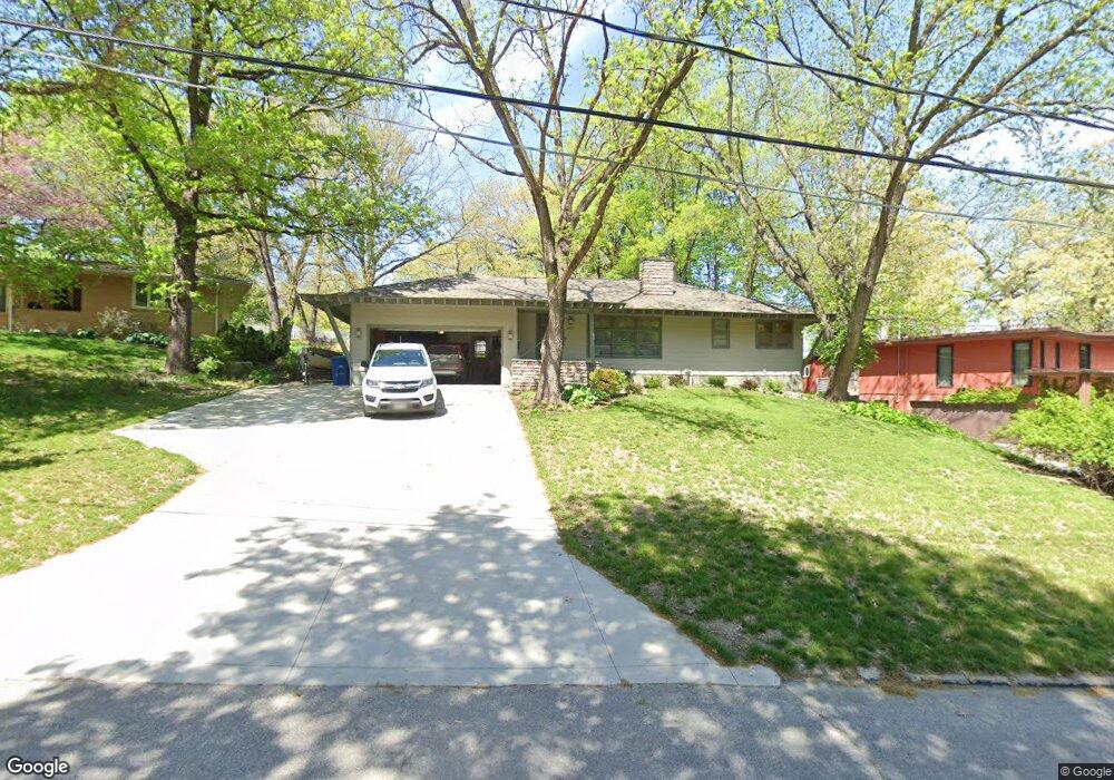
3921 Muskogee Ave Des Moines, IA 50312
Salisbury Oaks NeighborhoodEstimated Value: $329,479 - $400,000
3
Beds
2
Baths
1,230
Sq Ft
$302/Sq Ft
Est. Value
About This Home
This home is located at 3921 Muskogee Ave, Des Moines, IA 50312 and is currently estimated at $371,620, approximately $302 per square foot. 3921 Muskogee Ave is a home located in Polk County with nearby schools including Greenwood Elementary School, Callanan Middle School, and Roosevelt High School.
Ownership History
Date
Name
Owned For
Owner Type
Purchase Details
Closed on
Jul 1, 2002
Sold by
Sexton Sean M and Moore Jodi L
Bought by
Moon Byron M and Moon Shirley R
Current Estimated Value
Home Financials for this Owner
Home Financials are based on the most recent Mortgage that was taken out on this home.
Original Mortgage
$147,250
Outstanding Balance
$63,395
Interest Rate
6.93%
Estimated Equity
$308,225
Create a Home Valuation Report for This Property
The Home Valuation Report is an in-depth analysis detailing your home's value as well as a comparison with similar homes in the area
Home Values in the Area
Average Home Value in this Area
Purchase History
| Date | Buyer | Sale Price | Title Company |
|---|---|---|---|
| Moon Byron M | $154,500 | -- |
Source: Public Records
Mortgage History
| Date | Status | Borrower | Loan Amount |
|---|---|---|---|
| Open | Moon Byron M | $147,250 |
Source: Public Records
Tax History Compared to Growth
Tax History
| Year | Tax Paid | Tax Assessment Tax Assessment Total Assessment is a certain percentage of the fair market value that is determined by local assessors to be the total taxable value of land and additions on the property. | Land | Improvement |
|---|---|---|---|---|
| 2024 | $5,686 | $306,500 | $93,500 | $213,000 |
| 2023 | $5,864 | $306,500 | $93,500 | $213,000 |
| 2022 | $5,818 | $257,700 | $80,700 | $177,000 |
| 2021 | $5,724 | $257,700 | $80,700 | $177,000 |
| 2020 | $5,942 | $238,000 | $74,200 | $163,800 |
| 2019 | $5,554 | $238,000 | $74,200 | $163,800 |
| 2018 | $5,314 | $215,200 | $65,900 | $149,300 |
| 2017 | $4,786 | $208,500 | $65,900 | $142,600 |
| 2016 | $4,658 | $185,500 | $57,500 | $128,000 |
| 2015 | $4,658 | $185,500 | $57,500 | $128,000 |
| 2014 | $4,360 | $179,200 | $54,900 | $124,300 |
Source: Public Records
Map
Nearby Homes
- 3908 Muskogee Ave
- 3934 Lincoln Place Dr
- 4101 Muskogee Ave
- 3939 River Oaks Dr
- 4004 John Lynde Rd
- 3950 John Lynde Rd
- 200 SW 42nd St
- 3545 Lincoln Place Dr
- 201 Foster Dr
- 181 38th Place
- 3511 Saint Johns Rd
- 140 34th St
- 3304 Saint Johns Rd
- 3217 John Lynde Rd
- 302 37th St
- 3225 Terrace Dr
- 330 42nd St
- 413 38th Place
- 4004 Grand Ave Unit 103
- 3920 Grand Ave Unit 2TW
- 3919 Muskogee Ave
- 3929 Muskogee Ave
- 3909 Brentwood Dr
- 3937 Muskogee Ave
- 3911 Muskogee Ave
- 3918 Muskogee Ave
- 3912 Muskogee Ave
- 3928 Muskogee Ave
- 3901 Brentwood Dr
- 3901 Muskogee Ave
- 4008 Muskogee Ave
- 4003 Muskogee Ave
- 4009 Muskogee Ave
- 3926 Lincoln Place Dr
- 3922 Lincoln Place Dr
- 3918 Lincoln Place Dr
- 3912 Lincoln Place Dr
- 4001 Oak Forest Dr
- 4015 Muskogee Ave
- 3817 Brentwood Dr