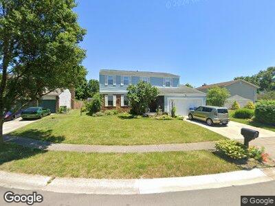
3922 Platte Ct Groveport, OH 43125
Groveport NeighborhoodEstimated Value: $276,000 - $288,316
4
Beds
3
Baths
1,772
Sq Ft
$160/Sq Ft
Est. Value
About This Home
This home is located at 3922 Platte Ct, Groveport, OH 43125 and is currently estimated at $282,829, approximately $159 per square foot. 3922 Platte Ct is a home located in Franklin County with nearby schools including Groveport Madison High School, Groveport Community School, and Eastland Preparatory Academy.
Ownership History
Date
Name
Owned For
Owner Type
Purchase Details
Closed on
Feb 22, 2006
Sold by
Remley June M
Bought by
Remley June M and Smith Carolina
Current Estimated Value
Purchase Details
Closed on
Feb 16, 2006
Sold by
Remley James E and Remley June M
Bought by
Remley June M
Purchase Details
Closed on
Aug 18, 1993
Bought by
Remley James E
Purchase Details
Closed on
May 1, 1985
Purchase Details
Closed on
Nov 1, 1979
Create a Home Valuation Report for This Property
The Home Valuation Report is an in-depth analysis detailing your home's value as well as a comparison with similar homes in the area
Home Values in the Area
Average Home Value in this Area
Purchase History
| Date | Buyer | Sale Price | Title Company |
|---|---|---|---|
| Remley June M | -- | None Available | |
| Remley James E | $86,500 | -- | |
| -- | -- | -- | |
| -- | $57,500 | -- |
Source: Public Records
Mortgage History
| Date | Status | Borrower | Loan Amount |
|---|---|---|---|
| Open | Remley June M | $5,000 |
Source: Public Records
Tax History Compared to Growth
Tax History
| Year | Tax Paid | Tax Assessment Tax Assessment Total Assessment is a certain percentage of the fair market value that is determined by local assessors to be the total taxable value of land and additions on the property. | Land | Improvement |
|---|---|---|---|---|
| 2024 | $3,446 | $91,070 | $20,580 | $70,490 |
| 2023 | $3,440 | $91,070 | $20,580 | $70,490 |
| 2022 | $1,826 | $44,910 | $8,190 | $36,720 |
| 2021 | $1,831 | $44,910 | $8,190 | $36,720 |
| 2020 | $1,834 | $44,910 | $8,190 | $36,720 |
| 2019 | $1,806 | $40,600 | $7,140 | $33,460 |
| 2018 | $1,727 | $40,600 | $7,140 | $33,460 |
| 2017 | $1,721 | $40,600 | $7,140 | $33,460 |
| 2016 | $1,618 | $34,580 | $6,230 | $28,350 |
| 2015 | $1,636 | $34,580 | $6,230 | $28,350 |
| 2014 | $1,654 | $34,580 | $6,230 | $28,350 |
| 2013 | $741 | $36,400 | $6,545 | $29,855 |
Source: Public Records
Map
Nearby Homes
- 4036 Walnut Crossing Dr
- 3722 Potomac St
- 3946 Wiston Dr Unit 3946
- 3246 Williams Rd
- 3080 Courtright Rd
- 3119 Westaire Ct
- 4468 Reinbeau Dr
- 4780 Cypress Grove Dr Unit 4780
- 5055 Gunston Dr
- 5010 Chipman Dr
- 3130 Marwick Rd
- 3093 Briar Ridge Rd
- 4343 Cobbleton Grove Cir
- 3866 Barkwillow Ln
- 3491 Noe Bixby Rd
- 3055 Representation Terrace Unit 216
- 3924 Barley Cir
- 2682 Buckwheat Ct
- 4828 Bay Grove Ct Unit 4828
- 3000 Westwick Rd
- 3922 Platte Ct
- 4018 Platte Ave
- 3914 Platte Ct
- 3917 Hendron Rd
- 3900 Platte Ct
- 4034 Platte Ave
- 3925 Hendron Rd
- 3909 Hendron Rd
- 4025 Platte Ave
- 3923 Platte Ct
- 3903 Platte Ct
- 4017 Platte Ave
- 3992 Platte Ave
- 4033 Platte Ave
- 3915 Platte Ct
- 4009 Platte Ave
- 3901 Hendron Rd
- 3909 Platte Ct
- 0 Platte Ave
- 3955 Hendron Rd