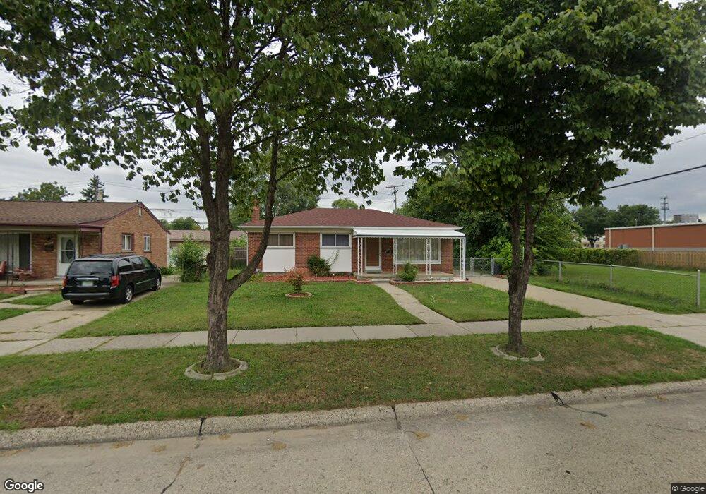
3931 Garrick Ave Warren, MI 48091
Southwest Warren NeighborhoodEstimated Value: $171,000 - $200,000
3
Beds
1
Bath
1,060
Sq Ft
$170/Sq Ft
Est. Value
About This Home
This home is located at 3931 Garrick Ave, Warren, MI 48091 and is currently estimated at $180,486, approximately $170 per square foot. 3931 Garrick Ave is a home located in Macomb County with nearby schools including Schofield Elementary School, Mound Park Elementary School, and Westview Elementary School.
Ownership History
Date
Name
Owned For
Owner Type
Purchase Details
Closed on
Aug 4, 2009
Sold by
Secretary Of Housing & Urban Development
Bought by
Rahman Ataur
Current Estimated Value
Purchase Details
Closed on
Dec 1, 2008
Sold by
Citimortgage Inc
Bought by
The Secretary Of Housing & Urban Develop
Purchase Details
Closed on
May 30, 2008
Sold by
Mincel Tina M and Ledbetter Scott O
Bought by
Citimortgage Inc
Purchase Details
Closed on
Aug 31, 2000
Sold by
Mincel Pauline
Bought by
Ledbetter Scott Q
Create a Home Valuation Report for This Property
The Home Valuation Report is an in-depth analysis detailing your home's value as well as a comparison with similar homes in the area
Home Values in the Area
Average Home Value in this Area
Purchase History
| Date | Buyer | Sale Price | Title Company |
|---|---|---|---|
| Rahman Ataur | $27,000 | None Available | |
| The Secretary Of Housing & Urban Develop | -- | None Available | |
| Citimortgage Inc | $103,174 | None Available | |
| Ledbetter Scott Q | $92,000 | -- |
Source: Public Records
Mortgage History
| Date | Status | Borrower | Loan Amount |
|---|---|---|---|
| Closed | Ledbetter Scott Q | -- |
Source: Public Records
Tax History
| Year | Tax Paid | Tax Assessment Tax Assessment Total Assessment is a certain percentage of the fair market value that is determined by local assessors to be the total taxable value of land and additions on the property. | Land | Improvement |
|---|---|---|---|---|
| 2025 | $1,732 | $88,610 | $0 | $0 |
| 2024 | $17 | $80,740 | $0 | $0 |
| 2023 | $1,598 | $69,550 | $0 | $0 |
| 2022 | $1,509 | $60,590 | $0 | $0 |
| 2021 | $1,568 | $57,090 | $0 | $0 |
| 2020 | $1,500 | $48,950 | $0 | $0 |
| 2019 | $1,410 | $38,440 | $0 | $0 |
| 2018 | $1,347 | $30,230 | $0 | $0 |
| 2017 | $1,335 | $29,550 | $3,100 | $26,450 |
| 2016 | $1,305 | $29,550 | $0 | $0 |
| 2015 | -- | $27,320 | $0 | $0 |
| 2012 | -- | $26,830 | $0 | $0 |
Source: Public Records
Map
Nearby Homes
- 3925 Toepfer Rd
- 3409 Jarvis Ave
- 3701 Berkshire Ave
- 21857 Le Fever Ave
- 22200 Le Fever Ave
- 21771 Cunningham Ave
- 21840 Cunningham Ave
- 3039 Pearl Ave
- 22694 Le Fever Ave
- 1936 Pearl Ave
- 3313 Dallas Ave
- 3167 Berkshire Ave
- 21044 Sunset Ave
- 3571 Los Angeles Ave
- 3471 Los Angeles Ave
- 4061 E 8 Mile Rd
- 21505 Audrey Ave
- 3511 Capitol Ave
- 20575 Dean St
- 2746 John B Ave
- 3917 Garrick Ave
- 3943 Garrick Ave
- 3903 Garrick Ave
- 3930 Garrick Ave
- 3838 Jarvis Ave
- 7025 Michael Ave
- 3850 Jarvis Ave
- 3815 Garrick Ave
- 3826 Jarvis Ave
- 4040 Garrick Ave
- 3862 Michael Ave
- 3874 Jarvis Ave
- 4060 Garrick Ave
- 3803 Garrick Ave
- 3812 Garrick Ave
- 3850 Michael Ave
- 3814 Jarvis Ave
- 3800 Garrick Ave
- 3751 Garrick Ave
- 21757 Ryan Rd
Your Personal Tour Guide
Ask me questions while you tour the home.