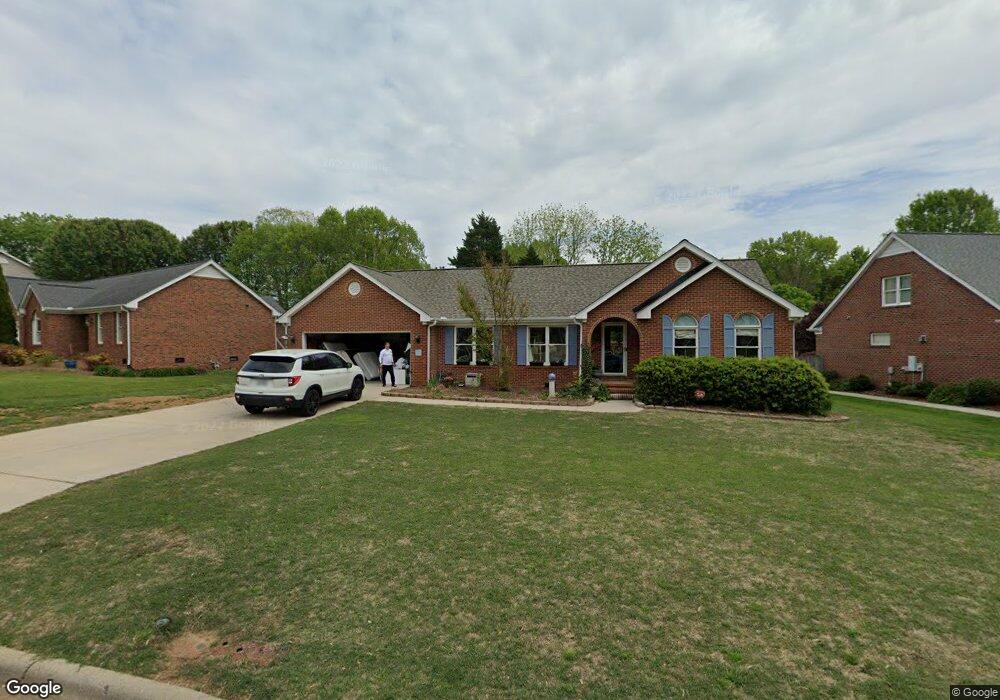
3932 Brandywine St High Point, NC 27265
Deep River NeighborhoodEstimated Value: $314,352 - $349,000
3
Beds
3
Baths
1,656
Sq Ft
$199/Sq Ft
Est. Value
About This Home
This home is located at 3932 Brandywine St, High Point, NC 27265 and is currently estimated at $330,088, approximately $199 per square foot. 3932 Brandywine St is a home located in Guilford County with nearby schools including Southwest Elementary School, Welborn Academy of Science & Technology, and T.W. Andrews High School.
Ownership History
Date
Name
Owned For
Owner Type
Purchase Details
Closed on
Mar 25, 2024
Sold by
Hutcheon Michael Jay and Hutcheon Sherri Renee
Bought by
Hutcheon William Bryce and Hutcheon Lauren Olivia
Current Estimated Value
Purchase Details
Closed on
Aug 24, 1998
Sold by
Grady Woodrow E and Grady Carmen R
Bought by
Hutcheon Michael Jay and Hutcheon Sherri Renee
Home Financials for this Owner
Home Financials are based on the most recent Mortgage that was taken out on this home.
Original Mortgage
$131,400
Interest Rate
6.91%
Create a Home Valuation Report for This Property
The Home Valuation Report is an in-depth analysis detailing your home's value as well as a comparison with similar homes in the area
Home Values in the Area
Average Home Value in this Area
Purchase History
| Date | Buyer | Sale Price | Title Company |
|---|---|---|---|
| Hutcheon William Bryce | -- | None Listed On Document | |
| Hutcheon Michael Jay | $168,000 | -- |
Source: Public Records
Mortgage History
| Date | Status | Borrower | Loan Amount |
|---|---|---|---|
| Previous Owner | Hutcheon Michael Jay | $131,400 |
Source: Public Records
Tax History
| Year | Tax Paid | Tax Assessment Tax Assessment Total Assessment is a certain percentage of the fair market value that is determined by local assessors to be the total taxable value of land and additions on the property. | Land | Improvement |
|---|---|---|---|---|
| 2025 | $2,744 | $199,100 | $52,500 | $146,600 |
| 2024 | $2,744 | $199,100 | $52,500 | $146,600 |
| 2023 | $2,744 | $199,100 | $52,500 | $146,600 |
| 2022 | $2,684 | $199,100 | $52,500 | $146,600 |
| 2021 | $2,316 | $168,100 | $36,800 | $131,300 |
| 2020 | $2,316 | $168,100 | $36,800 | $131,300 |
| 2019 | $2,316 | $168,100 | $0 | $0 |
| 2018 | $2,305 | $168,100 | $0 | $0 |
| 2017 | $2,305 | $168,100 | $0 | $0 |
| 2016 | $2,282 | $162,700 | $0 | $0 |
| 2015 | $2,294 | $162,700 | $0 | $0 |
| 2014 | $2,333 | $162,700 | $0 | $0 |
Source: Public Records
Map
Nearby Homes
- 4008 Deerfield St
- 3924 Braddock Rd
- 3905 Wynne Brook Ct
- 3912 Wynne Brook Ct
- 3421 Wildwood Ave
- 1517 Skeet Club Rd
- 1515 Skeet Club Rd
- 4518 Oak Hollow Dr
- 3753 Carvette Ct
- 4506 Calabria Ct
- 4218 Pelican St
- 4004 Baywater Point
- 4001 Tesa Ct
- 4404 Essex Ct
- 4126 Birchgarden Dr
- 4407 Oak Hollow Dr
- 4301 Bradbury Way
- 4307 Oak Hollow Dr
- 3650 Single Leaf Ct
- 4210 Birch Dr
- 3938 Brandywine St
- 3922 Brandywine St
- 3944 Brandywine St
- 3921 Braddock Rd
- 3401 Ashfield Ct
- 3405 Ashfield Ct
- 3935 Brandywine St
- 3933 Brandywine St
- 3929 Brandywine St
- 3923 Braddock Rd
- 3925 Brandywine St
- 3937 Brandywine St
- 3915 Braddock Rd
- 3941 Brandywine St
- 3925 Braddock Rd
- 3921 Brandywine St
- 3408 Ashfield Ct
- 3913 Braddock Rd
- 3945 Brandywine St
- 3917 Brandywine St
Your Personal Tour Guide
Ask me questions while you tour the home.