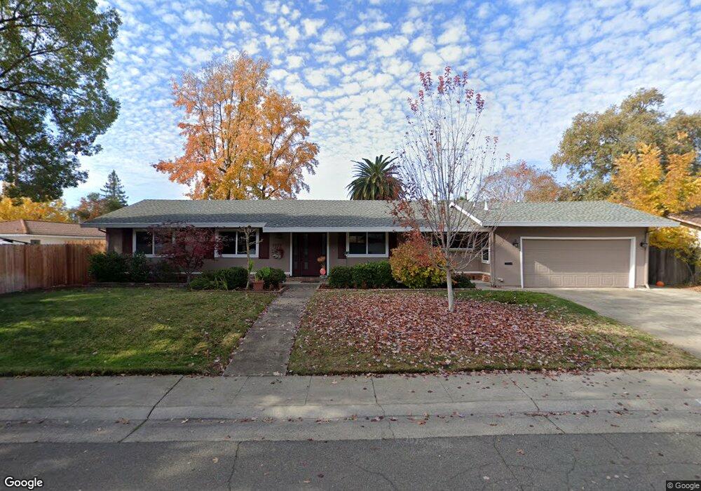
3933 Scotty Way Sacramento, CA 95821
North Edison NeighborhoodEstimated Value: $437,000 - $630,000
4
Beds
2
Baths
1,768
Sq Ft
$311/Sq Ft
Est. Value
About This Home
This home is located at 3933 Scotty Way, Sacramento, CA 95821 and is currently estimated at $549,362, approximately $310 per square foot. 3933 Scotty Way is a home located in Sacramento County with nearby schools including Pasadena Avenue Elementary School, Winston Churchill Middle School, and Mira Loma High School.
Ownership History
Date
Name
Owned For
Owner Type
Purchase Details
Closed on
Oct 9, 1998
Sold by
Cook John A and Estate Of Harold Leroy Cook
Bought by
Spil Peter M and Holder Virginia
Current Estimated Value
Home Financials for this Owner
Home Financials are based on the most recent Mortgage that was taken out on this home.
Original Mortgage
$138,400
Outstanding Balance
$30,014
Interest Rate
6.79%
Estimated Equity
$519,348
Create a Home Valuation Report for This Property
The Home Valuation Report is an in-depth analysis detailing your home's value as well as a comparison with similar homes in the area
Home Values in the Area
Average Home Value in this Area
Purchase History
| Date | Buyer | Sale Price | Title Company |
|---|---|---|---|
| Spil Peter M | $173,000 | Stewart Title |
Source: Public Records
Mortgage History
| Date | Status | Borrower | Loan Amount |
|---|---|---|---|
| Open | Spil Peter M | $138,400 |
Source: Public Records
Tax History Compared to Growth
Tax History
| Year | Tax Paid | Tax Assessment Tax Assessment Total Assessment is a certain percentage of the fair market value that is determined by local assessors to be the total taxable value of land and additions on the property. | Land | Improvement |
|---|---|---|---|---|
| 2025 | $3,174 | $271,192 | $70,537 | $200,655 |
| 2024 | $3,174 | $265,875 | $69,154 | $196,721 |
| 2023 | $3,093 | $260,663 | $67,799 | $192,864 |
| 2022 | $3,074 | $255,553 | $66,470 | $189,083 |
| 2021 | $3,022 | $250,543 | $65,167 | $185,376 |
| 2020 | $2,966 | $247,975 | $64,499 | $183,476 |
| 2019 | $2,906 | $243,114 | $63,235 | $179,879 |
| 2018 | $2,871 | $238,348 | $61,996 | $176,352 |
| 2017 | $2,842 | $233,676 | $60,781 | $172,895 |
| 2016 | $2,655 | $229,095 | $59,590 | $169,505 |
| 2015 | $2,608 | $225,654 | $58,695 | $166,959 |
| 2014 | $2,552 | $221,235 | $57,546 | $163,689 |
Source: Public Records
Map
Nearby Homes
- 4650 Gibbons Dr
- 4748 Salem Way
- 4186 Dena Way
- 4920 Patric Way
- 3807 Wingate Dr
- 3708 Gibbons Pkwy
- 4106 Wheat St
- 4316 Edison Ave
- 4711 Courtland Ln
- 4027 Hollow Wood Ct
- 3742 Eastern Ave
- 4912 Foster Way
- 4024 Hollow Wood Ct
- 4239 Daybreak Ln
- 4506 Woodson Ave
- 3916 Norris Ave
- 4301 Landolt Ave
- 5127 Walnut Pointe Ln
- 4098 Norris Ave
- 5233 Gibbons Dr
- 3941 Scotty Way
- 4639 Sagar Ave
- 3932 Milmar Way
- 3940 Milmar Way
- 3924 Milmar Way
- 3932 Scotty Way
- 3940 Scotty Way
- 3924 Scotty Way
- 3947 Scotty Way
- 3946 Milmar Way
- 3946 Scotty Way
- 3933 Milmar Way
- 4632 Sagar Ave
- 3916 Scotty Way
- 3925 Milmar Way
- 3941 Milmar Way
- 3947 Milmar Way
- 3952 Scotty Way
- 4624 Sagar Ave
- 3909 Scotty Way