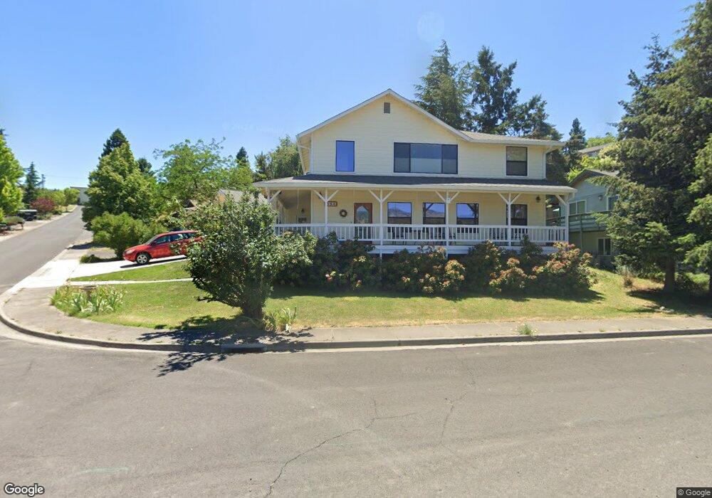
394 Clinton St Ashland, OR 97520
Cottage District NeighborhoodEstimated Value: $687,292 - $750,000
4
Beds
2
Baths
2,414
Sq Ft
$297/Sq Ft
Est. Value
About This Home
This home is located at 394 Clinton St, Ashland, OR 97520 and is currently estimated at $717,823, approximately $297 per square foot. 394 Clinton St is a home located in Jackson County with nearby schools including Walker Elementary School, Ashland Middle School, and Ashland High School.
Ownership History
Date
Name
Owned For
Owner Type
Purchase Details
Closed on
Jun 18, 2024
Sold by
Weibel Robert W and Standing Diana L
Bought by
Standing-Weibel Living Trust and Weibel
Current Estimated Value
Purchase Details
Closed on
May 19, 2000
Sold by
Arthur David
Bought by
Weibel Robert W and Standing Diana L
Home Financials for this Owner
Home Financials are based on the most recent Mortgage that was taken out on this home.
Original Mortgage
$242,500
Interest Rate
8.22%
Create a Home Valuation Report for This Property
The Home Valuation Report is an in-depth analysis detailing your home's value as well as a comparison with similar homes in the area
Home Values in the Area
Average Home Value in this Area
Purchase History
| Date | Buyer | Sale Price | Title Company |
|---|---|---|---|
| Standing-Weibel Living Trust | -- | None Listed On Document | |
| Weibel Robert W | $250,000 | Amerititle |
Source: Public Records
Mortgage History
| Date | Status | Borrower | Loan Amount |
|---|---|---|---|
| Previous Owner | Weibel Robert W | $242,500 |
Source: Public Records
Tax History Compared to Growth
Tax History
| Year | Tax Paid | Tax Assessment Tax Assessment Total Assessment is a certain percentage of the fair market value that is determined by local assessors to be the total taxable value of land and additions on the property. | Land | Improvement |
|---|---|---|---|---|
| 2025 | $5,233 | $337,530 | $104,370 | $233,160 |
| 2024 | $5,233 | $327,700 | $101,340 | $226,360 |
| 2023 | $5,063 | $318,160 | $98,390 | $219,770 |
| 2022 | $4,900 | $318,160 | $98,390 | $219,770 |
| 2021 | $4,734 | $308,900 | $95,530 | $213,370 |
| 2020 | $4,601 | $299,910 | $92,750 | $207,160 |
| 2019 | $4,528 | $282,700 | $87,430 | $195,270 |
| 2018 | $4,277 | $253,200 | $84,890 | $168,310 |
| 2017 | $3,917 | $253,200 | $84,890 | $168,310 |
| 2016 | $3,815 | $238,670 | $80,020 | $158,650 |
| 2015 | $3,668 | $238,670 | $80,020 | $158,650 |
| 2014 | $3,549 | $224,980 | $75,430 | $149,550 |
Source: Public Records
Map
Nearby Homes
- 401 Clinton St
- 419 Clinton St
- 403 Briscoe Place
- 533 N Mountain Ave
- 453 Williamson Way
- 411 N Mountain Ave
- 380 Hemlock Ln
- 224 Alicia St
- 500 Poplar Place
- 817 N Mountain Ave Unit 3
- 820 Satsuma Ct Unit 6
- 767 Oak St
- 597 Mariposa Ct Unit 14
- 815 Creek Stone Way
- 833 Cobblestone Ct
- 923 Mountain Meadows Cir Unit 12
- 910 Mountain Meadows Cir
- 945 Mountain Meadows Cir
- 941 Mountain Meadows Cir Unit 20
- 520 Helman St