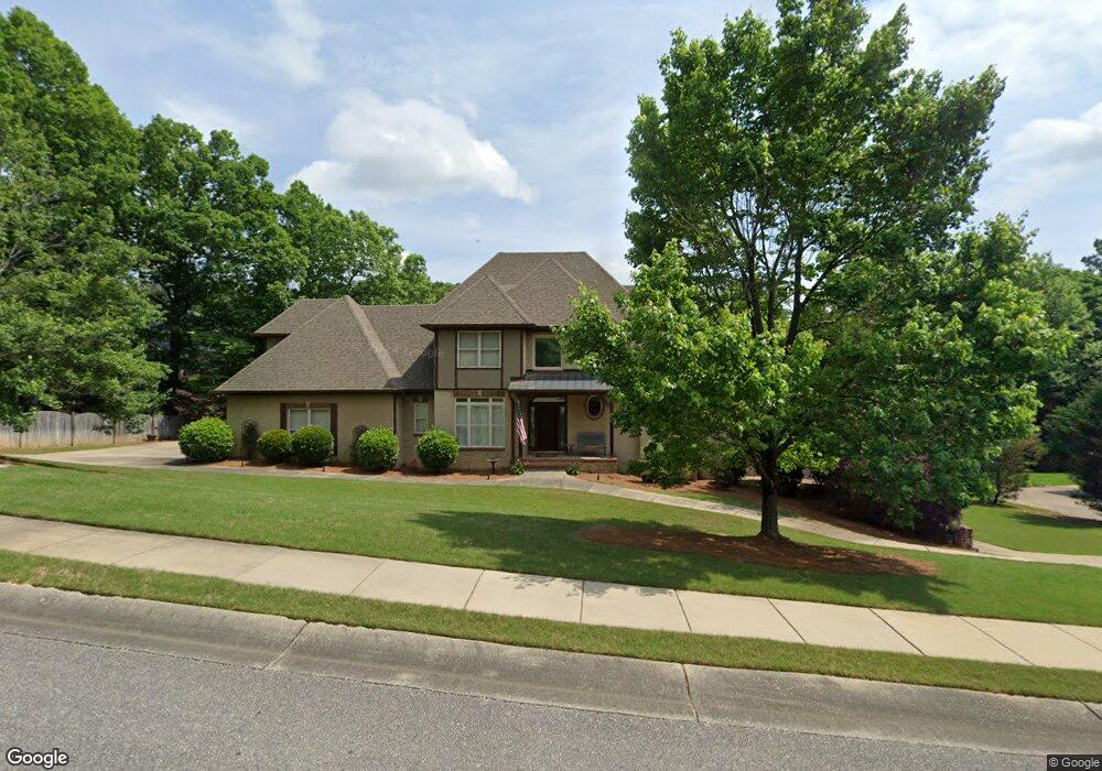
395 Knightsbridge Alabaster, AL 35007
Estimated Value: $493,000 - $600,690
--
Bed
1
Bath
3,420
Sq Ft
$156/Sq Ft
Est. Value
About This Home
This home is located at 395 Knightsbridge, Alabaster, AL 35007 and is currently estimated at $533,673, approximately $156 per square foot. 395 Knightsbridge is a home located in Shelby County with nearby schools including Thompson Intermediate School, Thompson Middle School, and Thompson High School.
Ownership History
Date
Name
Owned For
Owner Type
Purchase Details
Closed on
May 15, 2024
Sold by
Perkins Ronald Alan and Perkins Kena Michelle
Bought by
Kk & T Living Trust and Perkins
Current Estimated Value
Purchase Details
Closed on
Aug 18, 2006
Sold by
Mayhall Builder Inc
Bought by
Perkins Ronald and Perkins Kena
Home Financials for this Owner
Home Financials are based on the most recent Mortgage that was taken out on this home.
Original Mortgage
$379,900
Interest Rate
6.67%
Mortgage Type
Unknown
Purchase Details
Closed on
Nov 19, 2004
Sold by
Greenbriar Ltd
Bought by
Mayhall Builders Inc
Home Financials for this Owner
Home Financials are based on the most recent Mortgage that was taken out on this home.
Original Mortgage
$303,200
Interest Rate
5.57%
Mortgage Type
Construction
Create a Home Valuation Report for This Property
The Home Valuation Report is an in-depth analysis detailing your home's value as well as a comparison with similar homes in the area
Home Values in the Area
Average Home Value in this Area
Purchase History
| Date | Buyer | Sale Price | Title Company |
|---|---|---|---|
| Kk & T Living Trust | -- | None Listed On Document | |
| Perkins Ronald | -- | None Available | |
| Mayhall Builders Inc | $40,000 | -- |
Source: Public Records
Mortgage History
| Date | Status | Borrower | Loan Amount |
|---|---|---|---|
| Previous Owner | Perkins Ronald | $379,900 | |
| Previous Owner | Mayhall Builders Inc | $303,200 |
Source: Public Records
Tax History Compared to Growth
Tax History
| Year | Tax Paid | Tax Assessment Tax Assessment Total Assessment is a certain percentage of the fair market value that is determined by local assessors to be the total taxable value of land and additions on the property. | Land | Improvement |
|---|---|---|---|---|
| 2024 | $3,096 | $57,340 | $0 | $0 |
| 2023 | $2,821 | $53,000 | $0 | $0 |
| 2022 | $2,622 | $49,320 | $0 | $0 |
| 2021 | $2,411 | $45,400 | $0 | $0 |
| 2020 | $2,197 | $41,440 | $0 | $0 |
| 2019 | $2,195 | $41,400 | $0 | $0 |
| 2017 | $2,117 | $39,960 | $0 | $0 |
| 2015 | $2,016 | $38,100 | $0 | $0 |
| 2014 | $1,966 | $37,160 | $0 | $0 |
Source: Public Records
Map
Nearby Homes
- 217 Kensington Ln
- 104 Camden Cir
- 280 Cedar Grove Pkwy Unit 34
- 549 Ramsgate Dr
- 545 Ramsgate Dr
- 309 Cedar Grove Ct
- 113 Palm Dr
- 537 Ramsgate Dr
- 155 Victoria Station
- 204 Shalimar Cir
- 233 Norwick Forest Dr
- 306 Mayfair Cir
- 236 Queens Gate
- 217 Mayfair Park
- 1315 Yellowleaf Cir
- 128 Oak St
- 208 Queens Gate
- 501 Ramsgate Dr
- 109 Kingsley Cir
- 493 Ramsgate Dr
- 233 Kensington Ln
- 237 Kensington Ln
- 399 Knightsbridge
- 229 Kensington Ln
- 394 Knightsbridge
- 390 Knightsbridge
- 241 Kensington Ln
- 225 Kensington Ln
- 398 Knightsbridge
- 388 Knightsbridge
- 232 Kensington Ln
- 403 Knightsbridge
- 403 Knightsbridge Unit 49
- 381 Knightsbridge
- 386 Knightsbridge
- 221 Kensington Ln
- 226 Kensington Ln
- 236 Kensington Ln
- 259 Kensington Ln
- 224 Kensington Ln