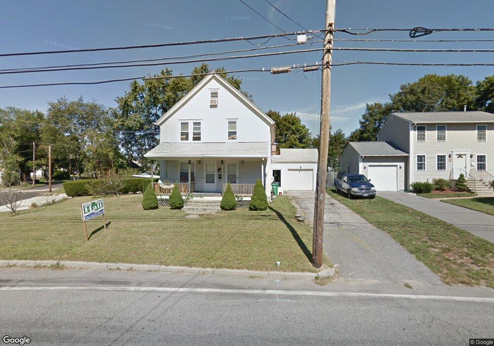
395 Samuel Gorton Ave Warwick, RI 02889
Long Meadow NeighborhoodEstimated Value: $479,000 - $732,000
4
Beds
3
Baths
2,026
Sq Ft
$291/Sq Ft
Est. Value
About This Home
This home is located at 395 Samuel Gorton Ave, Warwick, RI 02889 and is currently estimated at $589,732, approximately $291 per square foot. 395 Samuel Gorton Ave is a home located in Kent County with nearby schools including Saint Kevin School and Bishop Hendricken High School.
Ownership History
Date
Name
Owned For
Owner Type
Purchase Details
Closed on
Jun 27, 2022
Sold by
Wheeler William and Bager James
Bought by
Bager James
Current Estimated Value
Purchase Details
Closed on
Apr 2, 1996
Sold by
Grello Anthony P and Grello Nancy
Bought by
Wheeler William F and Bager James
Create a Home Valuation Report for This Property
The Home Valuation Report is an in-depth analysis detailing your home's value as well as a comparison with similar homes in the area
Home Values in the Area
Average Home Value in this Area
Purchase History
| Date | Buyer | Sale Price | Title Company |
|---|---|---|---|
| Bager James | -- | None Available | |
| Bager James | -- | None Available | |
| Wheeler William F | $110,000 | -- | |
| Wheeler William F | $110,000 | -- |
Source: Public Records
Mortgage History
| Date | Status | Borrower | Loan Amount |
|---|---|---|---|
| Previous Owner | Wheeler William F | $154,277 | |
| Previous Owner | Wheeler William F | $24,500 |
Source: Public Records
Tax History Compared to Growth
Tax History
| Year | Tax Paid | Tax Assessment Tax Assessment Total Assessment is a certain percentage of the fair market value that is determined by local assessors to be the total taxable value of land and additions on the property. | Land | Improvement |
|---|---|---|---|---|
| 2025 | $7,196 | $566,600 | $120,800 | $445,800 |
| 2024 | $6,306 | $435,800 | $105,000 | $330,800 |
| 2023 | $6,184 | $435,800 | $105,000 | $330,800 |
| 2022 | $5,713 | $305,000 | $65,900 | $239,100 |
| 2021 | $5,713 | $305,000 | $65,900 | $239,100 |
| 2020 | $5,713 | $305,000 | $65,900 | $239,100 |
| 2019 | $5,713 | $305,000 | $65,900 | $239,100 |
| 2018 | $4,680 | $225,000 | $65,900 | $159,100 |
| 2017 | $4,554 | $225,000 | $65,900 | $159,100 |
| 2016 | $4,554 | $225,000 | $65,900 | $159,100 |
| 2015 | $4,845 | $233,500 | $69,200 | $164,300 |
| 2014 | $4,684 | $233,500 | $69,200 | $164,300 |
| 2013 | $4,621 | $233,500 | $69,200 | $164,300 |
Source: Public Records
Map
Nearby Homes
- 391 Samuel Gorton Ave
- 390 Samuel Gorton Ave
- 400 Samuel Gorton Ave
- 383 Samuel Gorton Ave
- 407 Samuel Gorton Ave
- 384 Samuel Gorton Ave
- 0 Fairhaven Ave
- 380 Samuel Gorton Ave
- 6 Fairhaven Ave
- 12 Fairhaven Ave
- 79 Princeton Ave
- 374 Samuel Gorton Ave
- 52 Chester Ave
- 72 Princeton Ave
- 361 Arlington Ave
- 40 Chester Ave
- 369 Samuel Gorton Ave
- 370 Samuel Gorton Ave
- 422 Samuel Gorton Ave
- 425 Samuel Gorton Ave