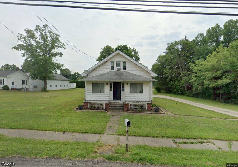
3972 State Route 44 Rootstown, OH 44272
Estimated Value: $188,000 - $249,939
4
Beds
2
Baths
1,764
Sq Ft
$127/Sq Ft
Est. Value
About This Home
This home is located at 3972 State Route 44, Rootstown, OH 44272 and is currently estimated at $223,485, approximately $126 per square foot. 3972 State Route 44 is a home located in Portage County with nearby schools including Rootstown Middle School - Schnee Building and Rootstown High School.
Ownership History
Date
Name
Owned For
Owner Type
Purchase Details
Closed on
Sep 14, 2004
Sold by
Davis Betty J and Davis Dorothy J
Bought by
Rootstown Township Trustees
Current Estimated Value
Purchase Details
Closed on
Jul 23, 2004
Sold by
Davis Betty J and Davis Dorothy J
Bought by
Davis Betty J and Davis Dorothy J
Purchase Details
Closed on
Jul 21, 2004
Sold by
Eldridge Jeffrey L and Eldridge Kathleen M
Bought by
Eldridge Jeffrey L and Eldridge Kathleen M
Purchase Details
Closed on
Jun 23, 1988
Bought by
Davis Helen P
Create a Home Valuation Report for This Property
The Home Valuation Report is an in-depth analysis detailing your home's value as well as a comparison with similar homes in the area
Purchase History
| Date | Buyer | Sale Price | Title Company |
|---|---|---|---|
| Rootstown Township Trustees | -- | Approved Statewide Title Age | |
| Davis Betty J | -- | -- | |
| Eldridge Jeffrey L | -- | -- | |
| Eldridge Jeffrey L | -- | -- | |
| Davis Helen P | -- | -- |
Source: Public Records
Tax History
| Year | Tax Paid | Tax Assessment Tax Assessment Total Assessment is a certain percentage of the fair market value that is determined by local assessors to be the total taxable value of land and additions on the property. | Land | Improvement |
|---|---|---|---|---|
| 2024 | $2,112 | $50,860 | $12,810 | $38,050 |
| 2023 | $1,946 | $41,830 | $11,270 | $30,560 |
| 2022 | $1,920 | $41,830 | $11,270 | $30,560 |
| 2021 | $1,916 | $41,830 | $11,270 | $30,560 |
| 2020 | $1,745 | $36,650 | $10,750 | $25,900 |
| 2019 | $1,751 | $36,650 | $10,750 | $25,900 |
| 2017 | $2,409 | $38,190 | $11,450 | $26,740 |
| 2016 | $1,882 | $38,190 | $11,450 | $26,740 |
Source: Public Records
Map
Nearby Homes
- 4079 Siefer Dr
- 3701 State Route 44
- 3689 Cherry Hill
- 0 Lynn Rd Unit 5110102
- V/L 2 Lynn Rd
- V/L Lynn Rd
- 4415 Farmette Dr
- 4691 Scenic Dr
- 4225 Hattrick Rd
- sub lot Lane Ave
- 4556 Rootstown Rd
- 3637 Old Forge Rd
- 0 Tallmadge Rd Unit 5189301
- 0 Tallmadge Rd Unit 5189314
- 4140 Sandy Lake Rd
- 3021 Hartville Rd
- 4058 Bayberry Knoll Ln
- 3925 Summit Rd
- 3080 Saxe Rd
- 5271 Aspen Meadow Dr
- 3958 State Route 44
- 3979 State Route 44
- 3959 State Route 44
- 3995 State Route 44
- 3955 State Route 44
- 3944 State Route 44
- 3987 State Route 44
- 3969 State Route 44
- 3947 State Route 44
- Tallmadge Rd
- 3932 State Route 44
- 3949 Cook Rd
- 4003 State Route 44
- 4202 Tallmadge Rd
- 3937 State Route 44
- 3962 Cook Rd
- 0 Cook Rd Unit 4031406
- 0 Cook Rd Unit 4009107
- 0 Cook Rd Unit 3225034
- 0 Cook Rd Unit 3225076
Your Personal Tour Guide
Ask me questions while you tour the home.