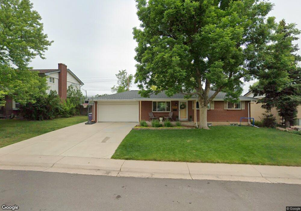
3983 W Quinn Place Denver, CO 80236
Fort Logan NeighborhoodEstimated Value: $522,000 - $576,000
5
Beds
2
Baths
2,080
Sq Ft
$262/Sq Ft
Est. Value
About This Home
This home is located at 3983 W Quinn Place, Denver, CO 80236 and is currently estimated at $545,825, approximately $262 per square foot. 3983 W Quinn Place is a home located in Denver County with nearby schools including Kaiser Elementary School, Bear Valley International School, and John F Kennedy High School.
Ownership History
Date
Name
Owned For
Owner Type
Purchase Details
Closed on
Jun 8, 2018
Sold by
Robertson Pamela L and Erskine Rebekah A
Bought by
Stam Andrew P and Stam Emily H
Current Estimated Value
Home Financials for this Owner
Home Financials are based on the most recent Mortgage that was taken out on this home.
Original Mortgage
$346,500
Outstanding Balance
$299,664
Interest Rate
4.5%
Mortgage Type
New Conventional
Estimated Equity
$246,161
Create a Home Valuation Report for This Property
The Home Valuation Report is an in-depth analysis detailing your home's value as well as a comparison with similar homes in the area
Home Values in the Area
Average Home Value in this Area
Purchase History
| Date | Buyer | Sale Price | Title Company |
|---|---|---|---|
| Stam Andrew P | $385,000 | Arapahoe Title Services Llc |
Source: Public Records
Mortgage History
| Date | Status | Borrower | Loan Amount |
|---|---|---|---|
| Open | Stam Andrew P | $346,500 |
Source: Public Records
Tax History Compared to Growth
Tax History
| Year | Tax Paid | Tax Assessment Tax Assessment Total Assessment is a certain percentage of the fair market value that is determined by local assessors to be the total taxable value of land and additions on the property. | Land | Improvement |
|---|---|---|---|---|
| 2024 | $2,725 | $34,410 | $2,480 | $31,930 |
| 2023 | $2,666 | $34,410 | $2,480 | $31,930 |
| 2022 | $2,211 | $27,800 | $6,390 | $21,410 |
| 2021 | $2,135 | $28,610 | $6,580 | $22,030 |
| 2020 | $1,982 | $26,710 | $5,980 | $20,730 |
| 2019 | $1,926 | $26,710 | $5,980 | $20,730 |
| 2018 | $1,757 | $22,710 | $5,420 | $17,290 |
| 2017 | $1,196 | $22,710 | $5,420 | $17,290 |
| 2016 | $862 | $18,530 | $5,994 | $12,536 |
| 2015 | $826 | $18,530 | $5,994 | $12,536 |
| 2014 | $539 | $12,980 | $3,431 | $9,549 |
Source: Public Records
Map
Nearby Homes
- 4095 W Radcliff Ave
- 3831 W Rutgers Place
- 4415 S Tennyson St
- 4445 S Lowell Blvd
- 4155 W Stanford Ave
- 3616 W Radcliff Ave Unit D9
- 4201 W Tufts Ave
- 3461 W Edgemore Place
- 3963 W Temple Place
- 4621 S Perry Way
- 3713 W Union Ave
- 4474 S Vrain St
- 4643 S Lowell Blvd Unit B
- 3659 W Union Ave Unit F4
- 4621 S Lowell Blvd Unit J6
- 4640 W Princeton Ave
- 4665 S Raleigh St
- 3742 W Union Ave
- 4720 W Stanford Ave
- 3590 W Pimlico Ave
- 3965 W Quinn Place
- 4001 W Quinn Place
- 4013 W Quinn Place
- 3984 W Quinn Place
- 3949 W Quinn Place
- 3966 W Quinn Place
- 4031 W Quinn Place
- 4002 W Quinn Place
- 3950 W Quinn Place
- 3933 W Quinn Place
- 4061 W Quinn Place
- 4012 W Quinn Place
- 3934 W Quinn Place
- 3917 W Quinn Place
- 4062 W Quinn Place
- 4091 W Quinn Place
- 4022 W Quinn Place
- 3918 W Quinn Place
- 3943 W Quigley Dr
- 3953 W Quigley Dr