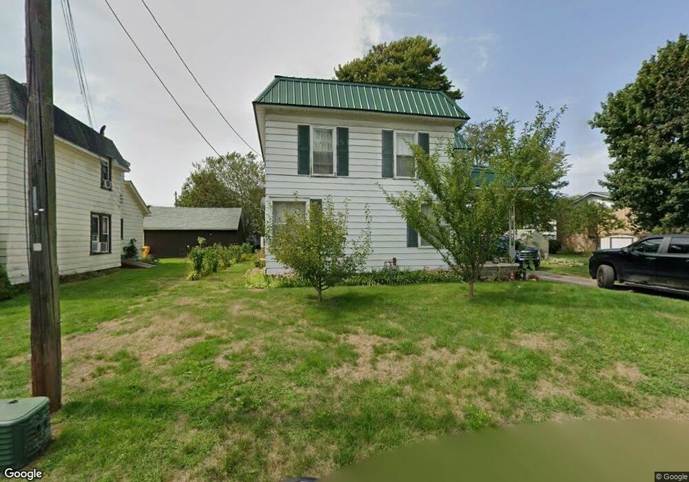
399 Jennie St Conneaut, OH 44030
Estimated Value: $105,000 - $182,000
3
Beds
2
Baths
1,348
Sq Ft
$99/Sq Ft
Est. Value
About This Home
This home is located at 399 Jennie St, Conneaut, OH 44030 and is currently estimated at $133,556, approximately $99 per square foot. 399 Jennie St is a home located in Ashtabula County with nearby schools including Lakeshore Primary Elementary School, Gateway Elementary School, and Conneaut Middle School.
Ownership History
Date
Name
Owned For
Owner Type
Purchase Details
Closed on
Apr 17, 2021
Sold by
White Theresa and White Corey
Bought by
Hartshorn Nicholas T
Current Estimated Value
Purchase Details
Closed on
Nov 3, 2009
Sold by
Specht John W and Specht Margaret L
Bought by
Hartshorn Nicholas T and Hartshorn Teresa
Home Financials for this Owner
Home Financials are based on the most recent Mortgage that was taken out on this home.
Original Mortgage
$66,326
Interest Rate
5.07%
Mortgage Type
New Conventional
Create a Home Valuation Report for This Property
The Home Valuation Report is an in-depth analysis detailing your home's value as well as a comparison with similar homes in the area
Home Values in the Area
Average Home Value in this Area
Purchase History
| Date | Buyer | Sale Price | Title Company |
|---|---|---|---|
| Hartshorn Nicholas T | -- | None Available | |
| Hartshorn Nicholas T | -- | None Listed On Document | |
| Hartshorn Nicholas T | $65,000 | Chicago Title Agency |
Source: Public Records
Mortgage History
| Date | Status | Borrower | Loan Amount |
|---|---|---|---|
| Previous Owner | Hartshorn Nicholas T | $66,326 |
Source: Public Records
Tax History Compared to Growth
Tax History
| Year | Tax Paid | Tax Assessment Tax Assessment Total Assessment is a certain percentage of the fair market value that is determined by local assessors to be the total taxable value of land and additions on the property. | Land | Improvement |
|---|---|---|---|---|
| 2024 | $1,762 | $24,090 | $2,490 | $21,600 |
| 2023 | $1,143 | $24,090 | $2,490 | $21,600 |
| 2022 | $1,034 | $19,180 | $1,890 | $17,290 |
| 2021 | $1,051 | $19,180 | $1,890 | $17,290 |
| 2020 | $1,051 | $19,180 | $1,890 | $17,290 |
| 2019 | $1,090 | $19,540 | $1,930 | $17,610 |
| 2018 | $1,040 | $19,540 | $1,930 | $17,610 |
| 2017 | $1,012 | $19,540 | $1,930 | $17,610 |
| 2016 | $977 | $17,050 | $1,680 | $15,370 |
| 2015 | $986 | $17,050 | $1,680 | $15,370 |
| 2014 | $889 | $17,050 | $1,680 | $15,370 |
| 2013 | $945 | $18,870 | $2,490 | $16,380 |
Source: Public Records
Map
Nearby Homes