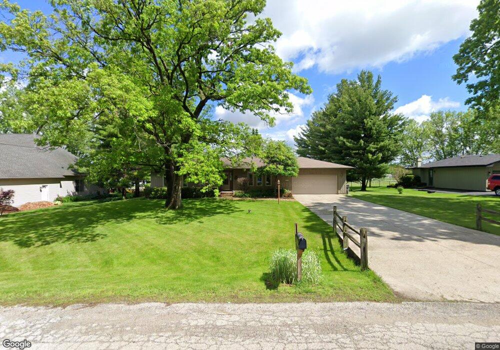
39W610 Lori Ln Elgin, IL 60124
Providence NeighborhoodEstimated Value: $358,058 - $418,000
3
Beds
2
Baths
1,730
Sq Ft
$218/Sq Ft
Est. Value
About This Home
This home is located at 39W610 Lori Ln, Elgin, IL 60124 and is currently estimated at $377,515, approximately $218 per square foot. 39W610 Lori Ln is a home located in Kane County with nearby schools including Prairie View Grade School, Prairie Knolls Middle School, and Central Middle School.
Ownership History
Date
Name
Owned For
Owner Type
Purchase Details
Closed on
Nov 6, 2024
Sold by
Schmidt Albert F and Schmidt Judith A
Bought by
Albert F Schmidt And Judith A Schmidt Joint D and Schmidt
Current Estimated Value
Create a Home Valuation Report for This Property
The Home Valuation Report is an in-depth analysis detailing your home's value as well as a comparison with similar homes in the area
Home Values in the Area
Average Home Value in this Area
Purchase History
| Date | Buyer | Sale Price | Title Company |
|---|---|---|---|
| Albert F Schmidt And Judith A Schmidt Joint D | -- | None Listed On Document | |
| Albert F Schmidt And Judith A Schmidt Joint D | -- | None Listed On Document |
Source: Public Records
Tax History
| Year | Tax Paid | Tax Assessment Tax Assessment Total Assessment is a certain percentage of the fair market value that is determined by local assessors to be the total taxable value of land and additions on the property. | Land | Improvement |
|---|---|---|---|---|
| 2024 | $6,185 | $95,091 | $23,953 | $71,138 |
| 2023 | $5,865 | $86,016 | $21,667 | $64,349 |
| 2022 | $5,774 | $77,741 | $19,577 | $58,164 |
| 2021 | $5,462 | $72,429 | $18,913 | $53,516 |
| 2020 | $5,434 | $71,127 | $18,573 | $52,554 |
| 2019 | $5,428 | $70,207 | $18,333 | $51,874 |
| 2018 | $5,393 | $70,155 | $18,944 | $51,211 |
| 2017 | $5,119 | $67,705 | $18,464 | $49,241 |
| 2016 | $4,980 | $61,765 | $18,026 | $43,739 |
| 2015 | -- | $63,938 | $18,026 | $45,912 |
| 2014 | -- | $65,854 | $18,026 | $47,828 |
| 2013 | -- | $68,226 | $18,334 | $49,892 |
Source: Public Records
Map
Nearby Homes
- 1159 Falcon Ridge Dr
- 1121 Iron Horse Ct
- 1103 Championship Dr
- 9N930 Koshare Cir
- 4378 John Milton Rd
- 313 Monument Rd
- 3539 Crosswater Ct
- 3553 Doral Dr
- 3545 S Riding Ridge
- 3681 Congressional Pkwy
- 3658 Thornhill Dr
- 9N827 Beckman Trail
- 411 Hopkins Ave
- 38W512 Bittersweet Ln
- 424 Acushnet St
- 11N080 Juliet Dr Unit 2
- 3641 Eldorado Rd
- 408 Fountain Ave
- Lot 10 Russinwood Ct
- LOT 1 Kristin Dr
- 39W606 Lori Ln
- 39W654 Lori Ln
- LOT 6 Lori Ln
- 39W672 Lori Ln
- 39W609 Lori Ln Unit 1
- 39W651 Lori Ln Unit 1
- 39W605 Lori Ln
- 39W692 Lori Ln
- 39W579 Lori Ln
- 39W671 Lori Ln
- 39W700 Lori Ln
- 39W620 Bowes Rd
- 39W691 Lori Ln Unit 1
- 39W596 Bowes Rd Unit 1
- 39W720 Lori Ln
- 39W719 Lori Ln
- 39W515 Lori Ln
- 9N780 Apache Run
- 9N690 Hogan Hill
- 9N796 Apache Run
Your Personal Tour Guide
Ask me questions while you tour the home.