
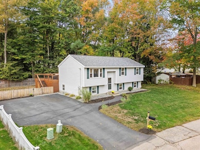
4 Columbine Place Concord, NH 03303
West Concord NeighborhoodEstimated payment $2,798/month
Highlights
- Wood Flooring
- Cedar Closet
- Hot Water Heating System
- Bonus Room
- Combination Kitchen and Dining Room
- Level Lot
About This Home
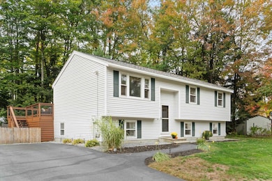
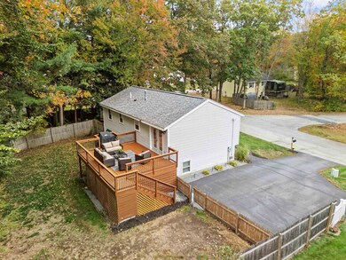
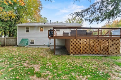
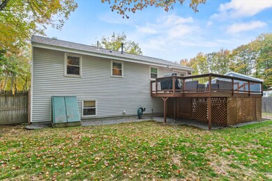
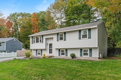
Welcome to 4 Columbine Place! This bright and inviting 3 bedroom, 1 bath split level is nestled on a quiet cul-de-sac in the heart of Concord, NH. Inside, you will find a well-maintained home that offers a functional layout filled with natural light, perfect for both everyday living and entertaining. The inviting family room and dining area offer large windows that flood the space with sunshine. The kitchen offers ample cabinetry, stainless steel appliances and overlooks the private backyard. All four bedrooms provide generous space and flexibility for a home office, guest room, or a growing household. Downstairs, the partially finished lower level provides additional living space and storage options. Outside, enjoy a peaceful yard with mature trees and room to garden, play, or simply relax.Freshly painted interior, fresehened deck, natural gas, public water/sewer and fenced in yard all located just minutes from schools, shopping, dining, and commuter routes. This home blends comfort, convenience, and value. Don’t miss your chance to own this gem in one of Concord’s most established neighborhoods!
Listing Agent
Coldwell Banker Realty Bedford NH Brokerage Phone: 603-234-1316 License #072642 Listed on: 10/15/2025

Home Details
Home Type
- Single Family
Est. Annual Taxes
- $7,385
Year Built
- Built in 1986
Lot Details
- 9,583 Sq Ft Lot
- Level Lot
- Property is zoned RS
Parking
- Paved Parking
Home Design
- Split Level Home
- Concrete Foundation
- Vinyl Siding
Interior Spaces
- Property has 1 Level
- Combination Kitchen and Dining Room
- Bonus Room
- Finished Basement
- Interior Basement Entry
Kitchen
- Microwave
- Dishwasher
Flooring
- Wood
- Carpet
- Laminate
Bedrooms and Bathrooms
- 3 Bedrooms
- Cedar Closet
- 1 Full Bathroom
Laundry
- Dryer
- Washer
Utilities
- Hot Water Heating System
- Cable TV Available
Listing and Financial Details
- Tax Lot 75
- Assessor Parcel Number 204
Map
Home Values in the Area
Average Home Value in this Area
Tax History
| Year | Tax Paid | Tax Assessment Tax Assessment Total Assessment is a certain percentage of the fair market value that is determined by local assessors to be the total taxable value of land and additions on the property. | Land | Improvement |
|---|---|---|---|---|
| 2024 | $7,385 | $266,700 | $101,700 | $165,000 |
| 2023 | $7,164 | $266,700 | $101,700 | $165,000 |
| 2022 | $6,905 | $266,700 | $101,700 | $165,000 |
| 2021 | $6,700 | $266,700 | $101,700 | $165,000 |
| 2020 | $6,259 | $233,900 | $81,600 | $152,300 |
| 2019 | $5,625 | $202,500 | $76,500 | $126,000 |
| 2018 | $5,782 | $205,100 | $73,400 | $131,700 |
| 2017 | $5,428 | $192,200 | $69,700 | $122,500 |
| 2016 | $5,064 | $183,000 | $69,700 | $113,300 |
| 2015 | $4,790 | $175,200 | $67,500 | $107,700 |
| 2014 | $4,697 | $175,200 | $67,500 | $107,700 |
| 2013 | $4,482 | $175,200 | $67,500 | $107,700 |
| 2012 | $4,304 | $176,600 | $67,500 | $109,100 |
Property History
| Date | Event | Price | List to Sale | Price per Sq Ft |
|---|---|---|---|---|
| 10/22/2025 10/22/25 | Pending | -- | -- | -- |
| 10/15/2025 10/15/25 | For Sale | $415,000 | -- | $240 / Sq Ft |
Purchase History
| Date | Type | Sale Price | Title Company |
|---|---|---|---|
| Deed | $187,500 | -- | |
| Deed | $94,700 | -- | |
| Warranty Deed | $88,100 | -- |
Mortgage History
| Date | Status | Loan Amount | Loan Type |
|---|---|---|---|
| Open | $181,875 | Purchase Money Mortgage | |
| Previous Owner | $88,100 | Purchase Money Mortgage |
Source: PrimeMLS
MLS Number: 5065893
APN: CNCD-000204Z-000000-000075
Disclaimer: Certain information contained herein is derived from information provided by parties other than Homes.com. All information provided is deemed reliable, but is not guaranteed to be accurate and should be independently verified.
![]() Copyright 2025 PrimeMLS, Inc. All rights reserved. This information is deemed reliable, but not guaranteed. The data relating to real estate displayed on this display comes in part from the IDX Program of PrimeMLS. The information being provided is for consumers’ personal, non-commercial use and may not be used for any purpose other than to identify prospective properties consumers may be interested in purchasing.
Copyright 2025 PrimeMLS, Inc. All rights reserved. This information is deemed reliable, but not guaranteed. The data relating to real estate displayed on this display comes in part from the IDX Program of PrimeMLS. The information being provided is for consumers’ personal, non-commercial use and may not be used for any purpose other than to identify prospective properties consumers may be interested in purchasing.
- 43 Woodbine Ave
- 6 Foxglove Terrace
- 120 Fisherville Rd Unit 176
- 120 Fisherville Rd Unit 138
- 0 Sewalls Falls & Abbott Rd Unit Multiple
- 4 Tanager Cir Unit 8
- 4 Tanager Cir Unit 7
- 4 Tanager Cir Unit 4
- 4 Tanager Cir Unit 3
- 4 Tanager Cir Unit 2
- 2 Tanager Cir Unit 3
- 117 Sewalls Falls Rd
- 145 Abbott Rd
- Lots 6-11 Sewalls Falls & Abbott Rd
- 125 Sewalls Falls Rd
- 139 Abbott Rd
- 70 Abbott Rd
- 0 Sewalls Falls Rd Unit 21
- 127 Sewalls Falls Rd
- 129 Fisherville Rd Unit 4