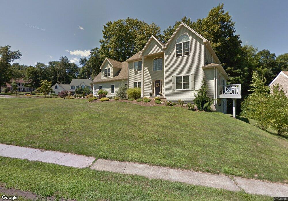
4 Farm View Cir Middletown, CT 06457
Estimated Value: $546,000 - $613,000
3
Beds
3
Baths
2,628
Sq Ft
$216/Sq Ft
Est. Value
About This Home
This home is located at 4 Farm View Cir, Middletown, CT 06457 and is currently estimated at $567,862, approximately $216 per square foot. 4 Farm View Cir is a home located in Middlesex County with nearby schools including Wesley School, Middletown High School, and St John Paul II School.
Ownership History
Date
Name
Owned For
Owner Type
Purchase Details
Closed on
Oct 14, 1998
Sold by
Trican Rlty Llc
Bought by
Medici Donna M
Current Estimated Value
Home Financials for this Owner
Home Financials are based on the most recent Mortgage that was taken out on this home.
Original Mortgage
$51,400
Interest Rate
6.8%
Create a Home Valuation Report for This Property
The Home Valuation Report is an in-depth analysis detailing your home's value as well as a comparison with similar homes in the area
Home Values in the Area
Average Home Value in this Area
Purchase History
| Date | Buyer | Sale Price | Title Company |
|---|---|---|---|
| Medici Donna M | $51,400 | -- |
Source: Public Records
Mortgage History
| Date | Status | Borrower | Loan Amount |
|---|---|---|---|
| Open | Medici Donna M | $177,783 | |
| Closed | Medici Donna M | $176,000 | |
| Closed | Medici Donna M | $14,140 | |
| Closed | Medici Donna M | $51,400 |
Source: Public Records
Tax History
| Year | Tax Paid | Tax Assessment Tax Assessment Total Assessment is a certain percentage of the fair market value that is determined by local assessors to be the total taxable value of land and additions on the property. | Land | Improvement |
|---|---|---|---|---|
| 2025 | $11,613 | $313,770 | $64,620 | $249,150 |
| 2024 | $11,111 | $313,770 | $64,620 | $249,150 |
| 2023 | $10,546 | $313,770 | $64,620 | $249,150 |
| 2022 | $10,100 | $244,830 | $47,870 | $196,960 |
| 2021 | $6,310 | $250,340 | $47,870 | $202,470 |
| 2020 | $3,485 | $250,340 | $47,870 | $202,470 |
| 2019 | $6,090 | $250,340 | $47,870 | $202,470 |
| 2018 | $9,959 | $250,340 | $47,870 | $202,470 |
| 2017 | $9,474 | $244,930 | $58,430 | $186,500 |
| 2016 | $9,284 | $244,930 | $58,430 | $186,500 |
| 2015 | $9,079 | $244,930 | $58,430 | $186,500 |
| 2014 | $9,070 | $244,930 | $58,430 | $186,500 |
Source: Public Records
Map
Nearby Homes
- Lot 3 Coleman Rd
- Lot 2 Coleman Rd
- 15 Blue Spruce St
- 7 Blue Bell Ln
- 122 Baldwin Dr
- 3 Blue Bird Rd
- 909 Randolph Rd
- 70 Jack English Dr
- 56 Coles Rd
- 2 Yellow Orange Cir
- 672 Laurel Grove Rd
- 91 Gleeson Rd
- 0 Round Hill Lot 17 Rd
- 63 Millbrook Rd
- 45 Mckenna Dr
- 13 Mckenna Dr
- 18 Talcott Ridge Dr
- 58 Durant Terrace
- (Map 12, Lot 80A) Hubbard St
- 183 Aston Ln
- 165 Cranberry Ln
- 10 Farm View Cir
- 174 Cranberry Ln
- 188 Cranberry Ln
- 201 Cranberry Ln
- 155 Cranberry Ln
- 11 Farm View Cir
- 164 Cranberry Ln
- 198 Cranberry Ln
- 180 Cranberry Ln
- 211 Cranberry Ln
- 145 Cranberry Ln
- 154 Cranberry Ln
- 7 Farm View Cir
- 182 Cranberry Ln
- 210 Cranberry Ln
- 3 Pheasant Dr
- 119 Cranberry Ln
- 0 Pheasant Dr Unit N286357
- 0 Pheasant Dr Unit N286359
Your Personal Tour Guide
Ask me questions while you tour the home.