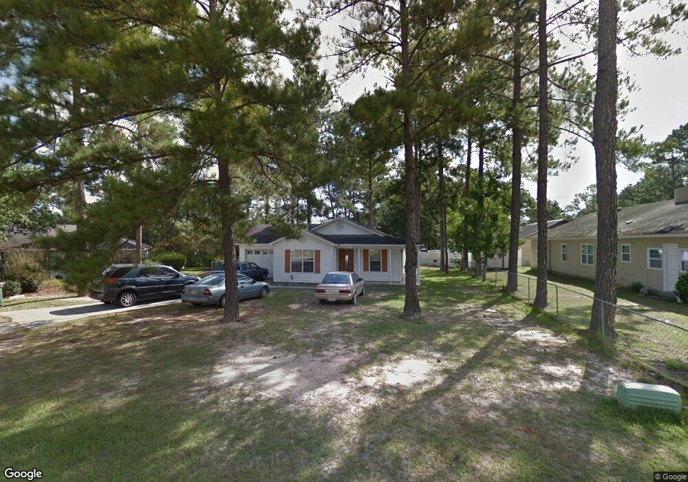
4 Forestridge Cir Valdosta, GA 31602
Estimated Value: $151,306 - $177,000
--
Bed
2
Baths
1,549
Sq Ft
$109/Sq Ft
Est. Value
About This Home
This home is located at 4 Forestridge Cir, Valdosta, GA 31602 and is currently estimated at $168,077, approximately $108 per square foot. 4 Forestridge Cir is a home located in Lowndes County with nearby schools including W.G. Nunn Elementary School, Newbern Middle School, and Valdosta High School.
Ownership History
Date
Name
Owned For
Owner Type
Purchase Details
Closed on
Dec 21, 2001
Sold by
Secretary Of Veterans Affairs
Bought by
Maxwell Gerald A
Current Estimated Value
Purchase Details
Closed on
Aug 7, 2001
Sold by
Wells Fargo Home Mortgage
Bought by
Secretary Of Veterans Affairs
Purchase Details
Closed on
Jul 9, 1999
Sold by
Sapp Willie M
Bought by
Sapp Keisha
Purchase Details
Closed on
Apr 28, 1998
Bought by
Sapp Willie M
Purchase Details
Closed on
Nov 25, 1996
Bought by
Blue Lake
Purchase Details
Closed on
Nov 14, 1995
Bought by
Blue Lake
Create a Home Valuation Report for This Property
The Home Valuation Report is an in-depth analysis detailing your home's value as well as a comparison with similar homes in the area
Home Values in the Area
Average Home Value in this Area
Purchase History
| Date | Buyer | Sale Price | Title Company |
|---|---|---|---|
| Maxwell Gerald A | -- | -- | |
| Secretary Of Veterans Affairs | -- | -- | |
| Wells Fargo Home Mortgage | -- | -- | |
| Sapp Keisha | -- | -- | |
| Sapp Willie M | $73,900 | -- | |
| Blue Lake | $13,000 | -- | |
| Blue Lake | -- | -- | |
| Blue Lake Builders Inc | $13,000 | -- |
Source: Public Records
Tax History Compared to Growth
Tax History
| Year | Tax Paid | Tax Assessment Tax Assessment Total Assessment is a certain percentage of the fair market value that is determined by local assessors to be the total taxable value of land and additions on the property. | Land | Improvement |
|---|---|---|---|---|
| 2024 | $879 | $37,480 | $5,200 | $32,280 |
| 2023 | $879 | $35,360 | $5,200 | $30,160 |
| 2022 | $964 | $34,540 | $5,200 | $29,340 |
| 2021 | $992 | $34,540 | $5,200 | $29,340 |
| 2020 | $1,014 | $34,540 | $5,200 | $29,340 |
| 2019 | $1,013 | $34,540 | $5,200 | $29,340 |
| 2018 | $1,026 | $34,540 | $5,200 | $29,340 |
| 2017 | $1,033 | $34,540 | $5,200 | $29,340 |
| 2016 | $1,032 | $34,540 | $5,200 | $29,340 |
| 2015 | $947 | $34,540 | $5,200 | $29,340 |
| 2014 | $963 | $34,540 | $5,200 | $29,340 |
Source: Public Records
Map
Nearby Homes
- 1647 Fresno St
- 1 Pomona Cir
- 1703 Largo Cir
- 2414 Deborah Dr
- 2517 Deborah Dr
- 2320 Barack Obama Blvd
- 2713 Pineview Dr Unit A&B
- 2400 Lowndes Dr
- 2310 Barack Obama Blvd
- 2435 Muscogee Dr
- 1724 Eli Place
- 2311 Lowndes Dr
- 1739 Eli Place
- 0 Northside Dr Unit 145194
- 904 Habersham Rd
- 1507 Leone Ave
- 1763 Eli Place
- 1761 Hyssop Crossing
- 1642 Lexington Cir
- 1852 Chestnut Dr
- 1604 Euclid St
- 6 Forestridge Cir
- 1606 Euclid St
- 8 Forestridge Cir
- 1665 Fresno St
- 1608 Euclid St
- 1667 Fresno St
- 1663 Fresno St
- 3 Forestridge Cir
- 1 Forestridge Cir
- 1607 Meadow Place
- 1605 Meadow Place
- 5 Forestridge Cir
- 1610 Euclid St
- 1661 Fresno St
- 1607 Euclid St
- 1609 Euclid St
- 1605 Euclid St
- 1701 Fresno St
- 1659 Fresno St