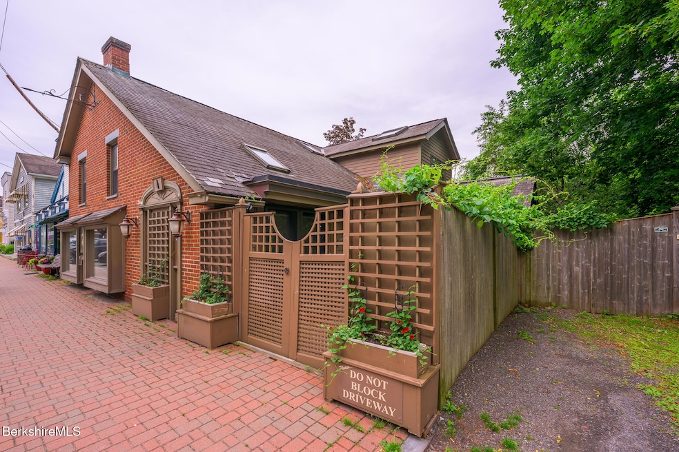


4 Main St West Stockbridge, MA 01266
Estimated payment $3,511/month
Highlights
- Water Views
- Deck
- Cathedral Ceiling
- Monument Mountain Regional High School Rated A-
- Contemporary Architecture
- Wood Flooring
About This Home
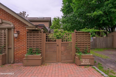
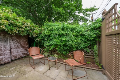
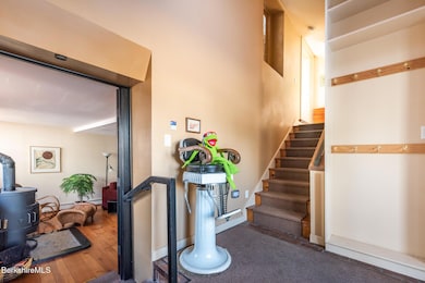
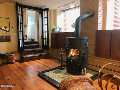
Beautiful riverside home offering comfort, flexibility, and in-town convenience. The front 2BR/2BA residence features soaring ceilings, skylights, an open kitchen, private riverfront deck, and an oversized ensuite bedroom. A spacious lower level provides room for guests, hobbies, or work. A charming garden area overlooking the Williams River adds outdoor enjoyment. The attached 1BR/1BA apartment has its own entrance, deck, and shared laundry access. Sale subject to owner leasing back the apartment for $2,000/mo. Custom built-ins, Rais wood stove, mini-split heat/AC, ceiling fans and generous storage. Just 3.9 miles to Tanglewood and steps from shops, dining, and recreation. Your Berkshire pied a terre awaits!
Home Details
Home Type
- Single Family
Est. Annual Taxes
- $4,694
Year Built
- 1890
Lot Details
- 3,920 Sq Ft Lot
- Lot Dimensions are 62 x 71
- Fenced Yard
- Partially Fenced Property
- Privacy
- Property is zoned Multi
Home Design
- Contemporary Architecture
- Slate Roof
- Masonry Siding
- Masonry
Interior Spaces
- 2,476 Sq Ft Home
- Cathedral Ceiling
- Ceiling Fan
- Skylights
- Wood Flooring
- Water Views
- Dishwasher
Bedrooms and Bathrooms
- 3 Bedrooms
- In-Law or Guest Suite
- 3 Full Bathrooms
Laundry
- Dryer
- Washer
Unfinished Basement
- Basement Fills Entire Space Under The House
- Interior Basement Entry
Parking
- 2 Parking Spaces
- No Garage
- Off-Street Parking
Outdoor Features
- Deck
- Exterior Lighting
Location
- Flood Risk
Schools
- Muddy Brook Reg. Elementary School
- Monument Valley Reg. Middle School
- Monument Mountain High School
Utilities
- Zoned Heating and Cooling
- Heat Pump System
- Electric Water Heater
- Cable TV Available
Map
Home Values in the Area
Average Home Value in this Area
Tax History
| Year | Tax Paid | Tax Assessment Tax Assessment Total Assessment is a certain percentage of the fair market value that is determined by local assessors to be the total taxable value of land and additions on the property. | Land | Improvement |
|---|---|---|---|---|
| 2025 | $4,694 | $487,900 | $49,900 | $438,000 |
| 2024 | $4,573 | $477,400 | $57,800 | $419,600 |
| 2023 | $4,655 | $451,500 | $55,000 | $396,500 |
| 2022 | $4,714 | $375,300 | $55,000 | $320,300 |
| 2021 | $4,878 | $350,700 | $55,300 | $295,400 |
| 2020 | $4,601 | $350,700 | $55,300 | $295,400 |
| 2019 | $4,383 | $361,300 | $55,300 | $306,000 |
| 2018 | $4,383 | $361,300 | $55,300 | $306,000 |
| 2017 | $4,509 | $361,300 | $55,300 | $306,000 |
| 2016 | $4,455 | $361,300 | $55,300 | $306,000 |
| 2015 | $4,278 | $361,300 | $55,300 | $306,000 |
| 2014 | $4,018 | $361,300 | $55,300 | $306,000 |
Property History
| Date | Event | Price | List to Sale | Price per Sq Ft |
|---|---|---|---|---|
| 11/25/2025 11/25/25 | For Sale | $595,000 | 0.0% | $240 / Sq Ft |
| 11/25/2025 11/25/25 | Price Changed | $595,000 | -6.3% | $240 / Sq Ft |
| 11/21/2025 11/21/25 | Off Market | $635,000 | -- | -- |
| 06/27/2025 06/27/25 | For Sale | $635,000 | -- | $256 / Sq Ft |
Purchase History
| Date | Type | Sale Price | Title Company |
|---|---|---|---|
| Deed | -- | None Available | |
| Deed | $450,000 | -- |
Mortgage History
| Date | Status | Loan Amount | Loan Type |
|---|---|---|---|
| Previous Owner | $337,500 | Purchase Money Mortgage |
Source: Berkshire County Board of REALTORS®
MLS Number: 246904
APN: WSTO-000104-000000-000034
Disclaimer: Certain information contained herein is derived from information provided by parties other than Homes.com. All information provided is deemed reliable, but is not guaranteed to be accurate and should be independently verified.
![]() IDX information is provided exclusively for consumers' personal, non-commercial use, that it may not be used for any purpose other than to identify prospective properties consumers may be interested in purchasing. Information deemed to be reliable but not guaranteed.
IDX information is provided exclusively for consumers' personal, non-commercial use, that it may not be used for any purpose other than to identify prospective properties consumers may be interested in purchasing. Information deemed to be reliable but not guaranteed.
The data relating to real estate for sale on this website comes from Berkshire County Board of Realtors and the Broker Reciprocity Program.
Copyright 2025 Berkshire County Board of Realtors. All rights reserved.
- 29 Main St
- 35 Main St
- 44 Main St
- 16 Swamp Rd
- 21 Stockbridge Rd
- 26 Lenox Rd
- 20 Moscow Rd
- 19 Washington Square
- 31 Gwenn Ln
- 45 Swamp
- 7 Silver Mine Ln
- 51 Albany Rd
- 17 Iron Mine Rd
- 30 Great Barrington Rd
- 0 Lenox Rd Unit 246122
- 0 Furnace Rd
- 2650 Swamp Rd
- 14 Old Tree Farm Rd
- 1 Old Tree Farm Rd
- 55 & 0 Maple Hill Rd
- 1292 Lenox Rd Unit 1
- 230 Middle Rd
- 208 Cunningham Hill Rd
- 68 Kemble St
- 34 Church St Unit 2B
- 2 Depot Rd
- 109 Housatonic St
- 105 McNamee Rd
- 207 Pleasant St
- 66 Brushwood Way
- 165 Stockbridge Rd
- 121 Queechy Lake Dr
- 1579 Pleasant St
- 1579 Pleasant St
- 1579 Pleasant St
- 73 W Center St
- 125 Center St Unit 2
- 703 W Housatonic St
- 5 Seekonk Rd
- 61 Henry Ave Unit 61 Henry Ave.
