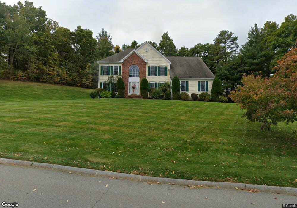
4 Maple Ridge Rd Methuen, MA 01844
The North End NeighborhoodEstimated Value: $851,000 - $968,000
3
Beds
3
Baths
2,716
Sq Ft
$331/Sq Ft
Est. Value
About This Home
This home is located at 4 Maple Ridge Rd, Methuen, MA 01844 and is currently estimated at $899,335, approximately $331 per square foot. 4 Maple Ridge Rd is a home located in Essex County with nearby schools including Methuen High School, Community Day Charter Public School - Gateway, and Saint Monica School.
Ownership History
Date
Name
Owned For
Owner Type
Purchase Details
Closed on
Nov 7, 2024
Sold by
Mccool John R and Mccool Deborah K
Bought by
Mccool Ft and Mccool
Current Estimated Value
Purchase Details
Closed on
Apr 18, 2001
Sold by
Ashwood Dev Co
Bought by
Mccool John R and Mccool Deborah K
Create a Home Valuation Report for This Property
The Home Valuation Report is an in-depth analysis detailing your home's value as well as a comparison with similar homes in the area
Home Values in the Area
Average Home Value in this Area
Purchase History
| Date | Buyer | Sale Price | Title Company |
|---|---|---|---|
| Mccool Ft | -- | None Available | |
| Mccool Ft | -- | None Available | |
| Mccool John R | $390,445 | -- | |
| Mccool John R | $390,445 | -- |
Source: Public Records
Mortgage History
| Date | Status | Borrower | Loan Amount |
|---|---|---|---|
| Previous Owner | Mccool John R | $50,000 | |
| Previous Owner | Mccool John R | $295,000 | |
| Previous Owner | Mccool John R | $276,000 |
Source: Public Records
Tax History
| Year | Tax Paid | Tax Assessment Tax Assessment Total Assessment is a certain percentage of the fair market value that is determined by local assessors to be the total taxable value of land and additions on the property. | Land | Improvement |
|---|---|---|---|---|
| 2025 | $8,609 | $813,700 | $319,200 | $494,500 |
| 2024 | $8,331 | $767,100 | $290,200 | $476,900 |
| 2023 | $7,869 | $672,600 | $259,100 | $413,500 |
| 2022 | $7,365 | $564,400 | $207,300 | $357,100 |
| 2021 | $6,951 | $527,000 | $197,000 | $330,000 |
| 2020 | $6,900 | $513,400 | $197,000 | $316,400 |
| 2019 | $6,811 | $480,000 | $186,600 | $293,400 |
| 2018 | $6,650 | $466,000 | $186,600 | $279,400 |
| 2017 | $6,487 | $442,800 | $186,600 | $256,200 |
| 2016 | $6,488 | $438,100 | $186,600 | $251,500 |
| 2015 | $6,260 | $428,800 | $186,600 | $242,200 |
Source: Public Records
Map
Nearby Homes
- 128 Pleasant Valley St
- 41 Brookdale Ave
- 5 Pilgrim Cir Unit C
- 10 Fenwick Cir
- 64 Pine Tree Dr Unit 64
- 27 Russell Farm Dr
- 30 Anderson Dr
- 2 Sequoia Dr Unit 2
- 40 Phoebe St Unit 101
- 60 Ames St
- 7 Tree Top Way
- 55 Phoebe St Unit 32
- 12 Scotland Heights Rd
- 159-161 Howe St
- 17 Ferry Rd
- 3 Adams Ave
- 6 Ferry Rd
- 64-66 Howe St
- Lot 108 Garden City Rd
- 687 Jackson St
- 5 Maple Ridge Rd
- 7 Maple Ridge Rd
- 3 Maple Ridge Rd
- 9 Birch Hill Dr
- 6 Maple Ridge Rd
- 1 Maple Ridge Rd
- 11 Birch Hill Dr
- 9 Maple Ridge Rd
- 15 Birch Hill Dr
- 8 Maple Ridge Rd
- 11 Maple Ridge Rd
- 10 Birch Hill Dr
- 8 Birch Hill Dr
- 12 Birch Hill Dr
- 10 Maple Ridge Rd
- 17 Birch Hill Dr
- 15 Maple Ridge Rd
- 45 Maple Ridge Rd
- 24 Maple Ridge Rd
- 22 Maple Ridge Rd
Your Personal Tour Guide
Ask me questions while you tour the home.