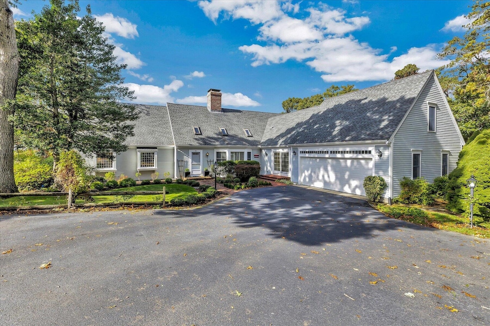
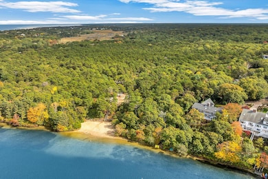
4 Maureens Way Dennis, MA 02638
Dennis Village NeighborhoodEstimated payment $13,639/month
Highlights
- Waterfront
- Wood Flooring
- Mud Room
- Deck
- 2 Fireplaces
- No HOA
About This Home
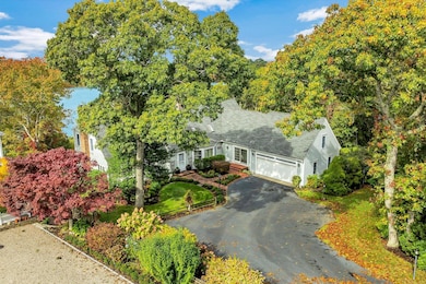
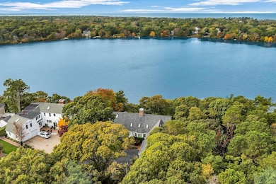
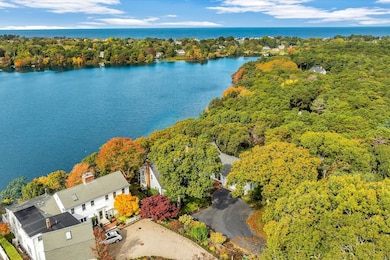
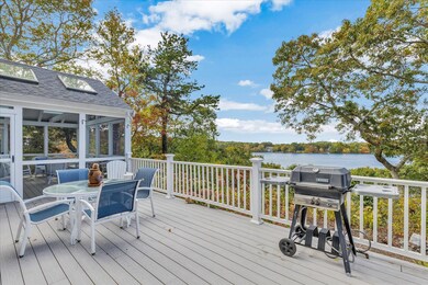
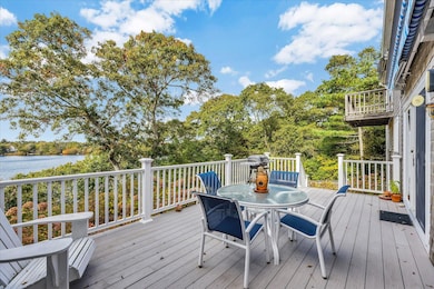
Welcome to this stunning 4-bedroom, 4.5-bath luxury Cape Cod residence overlooking picturesque Scargo Lake. Boasting 3,943 sq. ft. of beautifully finished living space on a .49-acre professionally landscaped lot, this home seamlessly blends classic Cape charm with modern amenities.Completely renovated and expanded in 2009, the home features wide pine floors, two fireplaces, and two wood-burning stoves for cozy New England living. The sunroom and spacious deck provide breathtaking lake views, perfect for relaxing or entertaining.The chef's kitchen, generous dining area, and spacious layout create an inviting atmosphere for family gatherings. Three of the four bedrooms offer en suite bathrooms, providing privacy and comfort for all. Enjoy year-round comfort with central air conditioning, a two-car garage, and an irrigation system maintaining the lush, landscaped grounds. After a day at nearby Corporation Beach, rinse off in the outdoor shower before unwinding by the fire.This is a rare offering on Scargo Lake with seclusion and privacy, yet close to all amenities in the charming village of Dennis.
Listing Agent
Berkshire Hathaway HomeServices Robert Paul Properties License #104240 Listed on: 10/17/2025

Home Details
Home Type
- Single Family
Est. Annual Taxes
- $8,712
Year Built
- Built in 1982 | Remodeled
Lot Details
- 0.49 Acre Lot
- Waterfront
- Property fronts a private road
- Property fronts an easement
- Street terminates at a dead end
- Landscaped
- Garden
Parking
- 2 Car Attached Garage
- Open Parking
Home Design
- Slab Foundation
- Poured Concrete
- Asphalt Roof
- Shingle Siding
- Concrete Perimeter Foundation
- Clapboard
Interior Spaces
- 3,943 Sq Ft Home
- 2-Story Property
- Wet Bar
- 2 Fireplaces
- Mud Room
- Screened Porch
- Interior Basement Entry
- Intercom
- Washer
Kitchen
- Cooktop
- Dishwasher
- Disposal
Flooring
- Wood
- Carpet
- Tile
Bedrooms and Bathrooms
- 4 Bedrooms
- Linen Closet
Outdoor Features
- Outdoor Shower
- Deck
Location
- Property is near shops
- Property is near a golf course
Utilities
- Central Air
- Heating Available
- Electric Water Heater
- Septic Tank
Listing and Financial Details
- Assessor Parcel Number DENN M:000354 P:014000
Community Details
Overview
- No Home Owners Association
- Near Conservation Area
Recreation
- Bike Trail
Map
Home Values in the Area
Average Home Value in this Area
Tax History
| Year | Tax Paid | Tax Assessment Tax Assessment Total Assessment is a certain percentage of the fair market value that is determined by local assessors to be the total taxable value of land and additions on the property. | Land | Improvement |
|---|---|---|---|---|
| 2025 | $8,712 | $2,011,900 | $704,300 | $1,307,600 |
| 2024 | $8,574 | $1,953,000 | $677,300 | $1,275,700 |
| 2023 | $8,164 | $1,748,200 | $588,300 | $1,159,900 |
| 2022 | $7,838 | $1,399,600 | $530,000 | $869,600 |
| 2021 | $7,667 | $1,271,500 | $519,600 | $751,900 |
| 2020 | $7,976 | $1,307,600 | $483,300 | $824,300 |
| 2019 | $7,674 | $1,243,800 | $509,400 | $734,400 |
| 2018 | $7,567 | $1,193,500 | $484,900 | $708,600 |
| 2017 | $7,341 | $1,193,600 | $485,000 | $708,600 |
| 2016 | $7,212 | $1,104,400 | $501,900 | $602,500 |
| 2015 | $7,068 | $1,104,400 | $501,900 | $602,500 |
| 2014 | $6,892 | $1,085,300 | $501,900 | $583,400 |
Property History
| Date | Event | Price | List to Sale | Price per Sq Ft |
|---|---|---|---|---|
| 10/17/2025 10/17/25 | For Sale | $2,450,000 | -- | $621 / Sq Ft |
Purchase History
| Date | Type | Sale Price | Title Company |
|---|---|---|---|
| Deed | -- | -- | |
| Deed | -- | -- | |
| Deed | $400,000 | -- |
Mortgage History
| Date | Status | Loan Amount | Loan Type |
|---|---|---|---|
| Previous Owner | $250,000 | No Value Available |
Source: Cape Cod & Islands Association of REALTORS®
MLS Number: 22505240
APN: DENN-000354-000000-000014
Disclaimer: Certain information contained herein is derived from information provided by parties other than Homes.com. All information provided is deemed reliable, but is not guaranteed to be accurate and should be independently verified.
![]() All data relating to real estate for sale on this page comes from the Broker Reciprocity (BR) of the Cape Cod & Islands Multiple Listing Service, Inc. Detailed information about real estate listings held by brokerage firms other than CC&I Assoc. of REALTORS®, Inc. includes the name of the listing company. Neither the listing company nor CC&I Assoc. of REALTORS®, Inc. shall be responsible for any typographical errors, misinformation, misprints and shall be held totally harmless. The Broker providing this data believes it to be correct, but advises interested parties to confirm any item before relying on it in a purchase decision. All properties are subject to prior sale, changes, or withdrawal. Copyright 2025 © Cape Cod & Islands Multiple Listing Service, Inc. All rights reserved.
All data relating to real estate for sale on this page comes from the Broker Reciprocity (BR) of the Cape Cod & Islands Multiple Listing Service, Inc. Detailed information about real estate listings held by brokerage firms other than CC&I Assoc. of REALTORS®, Inc. includes the name of the listing company. Neither the listing company nor CC&I Assoc. of REALTORS®, Inc. shall be responsible for any typographical errors, misinformation, misprints and shall be held totally harmless. The Broker providing this data believes it to be correct, but advises interested parties to confirm any item before relying on it in a purchase decision. All properties are subject to prior sale, changes, or withdrawal. Copyright 2025 © Cape Cod & Islands Multiple Listing Service, Inc. All rights reserved.
- 21 Compass Ln
- 831 Main St
- 35 Crown Grant Dr
- 25 Ronda Ln
- 19 Deacon Joseph Ln
- 59 Hope Ln
- 645 Main St Back Lot
- 153 Sesuit Neck Rd
- 15 Signal Hill Dr
- 102 Prince Way
- 6 Thomas Ct
- 1376 Bridge St Unit 16
- 61 Barque Cir
- 19 Whig St
- 6 Match Point
- 1706 Massachusetts 6a Unit 3
- 23 Stephen Phillips Rd
- 84 Hiram Pond Rd
- 1706 Route 6a Unit 3
- 73 Pilgrim Rd
- 25 Embassy Ln
- 25 Embassy St
- 28 Seminole Dr
- 70 Poinsettia Dr
- 6 Lauries Ln
- 94 Country Club Dr Unit Country Club
- 94 Country Club Dr Unit 94 Country Club Drive
- 873 Harwich Rd
- 24 Church St Unit A
- 12 Town Hall Ave
- 26 Lone Tree Rd Unit A
- 141 Division St Unit 4
- 576 Main St Unit 3
- 56 Center St Unit 2-3
- 5 Elwood Rd
- 28 Swan Lake Rd
- 1272 Mary Dunn Rd
- 110 Depot St
- 20 Trumet Rd
- 4 Summer St