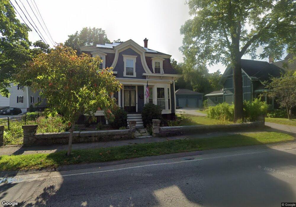
4 S Hampton Rd Amesbury, MA 01913
Estimated Value: $733,308 - $883,000
4
Beds
2
Baths
2,472
Sq Ft
$321/Sq Ft
Est. Value
About This Home
This home is located at 4 S Hampton Rd, Amesbury, MA 01913 and is currently estimated at $794,577, approximately $321 per square foot. 4 S Hampton Rd is a home located in Essex County with nearby schools including Amesbury High School and Amesbury Seventh-Day Adventist School.
Ownership History
Date
Name
Owned For
Owner Type
Purchase Details
Closed on
May 20, 2003
Sold by
Lamanuzzi Karen A and Lamanuzzi Leonard F
Bought by
Lamanuzzi Karen A
Current Estimated Value
Purchase Details
Closed on
Feb 28, 1997
Sold by
Mockler Colman M and Mockler Mary Jean
Bought by
Lamanuzzi Leonard F and Lamanuzzi Karen A
Purchase Details
Closed on
Dec 1, 1988
Sold by
Elwin Walter
Bought by
Mockler Colman
Create a Home Valuation Report for This Property
The Home Valuation Report is an in-depth analysis detailing your home's value as well as a comparison with similar homes in the area
Home Values in the Area
Average Home Value in this Area
Purchase History
| Date | Buyer | Sale Price | Title Company |
|---|---|---|---|
| Lamanuzzi Karen A | -- | -- | |
| Lamanuzzi Leonard F | $235,000 | -- | |
| Mockler Colman | $217,000 | -- |
Source: Public Records
Mortgage History
| Date | Status | Borrower | Loan Amount |
|---|---|---|---|
| Open | Mockler Colman | $55,000 | |
| Open | Mockler Colman | $280,000 | |
| Previous Owner | Mockler Colman | $60,000 |
Source: Public Records
Tax History
| Year | Tax Paid | Tax Assessment Tax Assessment Total Assessment is a certain percentage of the fair market value that is determined by local assessors to be the total taxable value of land and additions on the property. | Land | Improvement |
|---|---|---|---|---|
| 2025 | $9,875 | $645,400 | $292,700 | $352,700 |
| 2024 | $9,343 | $597,400 | $276,200 | $321,200 |
| 2023 | $9,172 | $561,300 | $240,100 | $321,200 |
| 2022 | $9,206 | $520,400 | $209,200 | $311,200 |
| 2021 | $8,023 | $439,600 | $162,200 | $277,400 |
| 2020 | $7,523 | $437,900 | $156,100 | $281,800 |
| 2019 | $7,238 | $394,000 | $156,100 | $237,900 |
| 2018 | $7,173 | $377,700 | $148,600 | $229,100 |
| 2017 | $7,675 | $384,700 | $148,600 | $236,100 |
| 2016 | $7,374 | $363,600 | $148,600 | $215,000 |
| 2015 | $7,325 | $356,600 | $148,600 | $208,000 |
| 2014 | $7,551 | $360,100 | $148,600 | $211,500 |
Source: Public Records
Map
Nearby Homes
- 105 Market St Unit B
- 101 Market St Unit B
- 5 Russell St Unit 1
- 149 Market St
- 25 Cedar St Unit 4
- 3 Tremont Ave Unit A
- 4 Clark St
- 48 Orchard St
- 97 Elm St
- 21 Congress St
- 25 Whittier Meadows Dr
- 21 River St
- 1 Hillside Ave Unit 3
- 4 Greenwood St
- 253 Main St
- 82 Monroe St
- 9 Elmwood St
- 20 Mason Ct
- 14 Mason Ct Unit 14
- 7 Hoyt Ave
- 6 S Hampton Rd
- 116 Market St
- 118 Market St
- 118 1/2 Market St
- 2 S Hampton Rd
- 8 S Hampton Rd
- 7 S Hampton Rd
- 115 Market St Unit B
- 115 Market St Unit A
- 12 S Hampton Rd
- 12 S Hampton Rd
- 12 S Hampton Rd Unit 12
- 10 S Hampton Rd
- 117 Market St
- 120 Market St
- 115 1/2 Market St Unit A
- 111 Market St
- 119 Market St
- 110 Market St
- 113 Market St
Your Personal Tour Guide
Ask me questions while you tour the home.