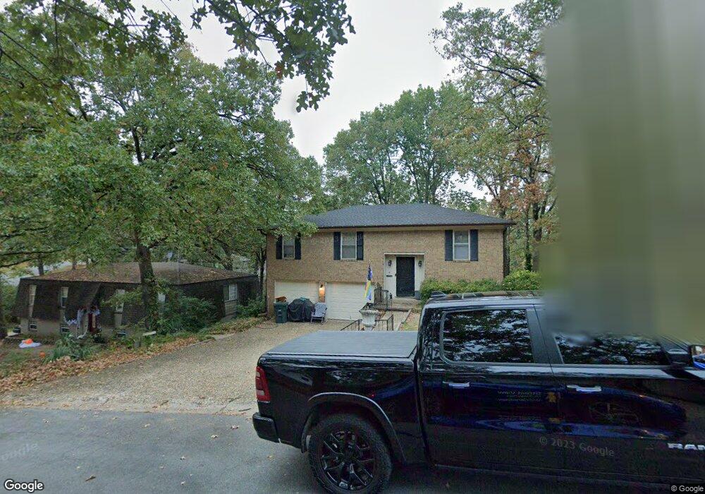
4 Warwick Rd Little Rock, AR 72205
West Markham NeighborhoodEstimated Value: $201,779 - $243,000
--
Bed
4
Baths
1,907
Sq Ft
$114/Sq Ft
Est. Value
About This Home
This home is located at 4 Warwick Rd, Little Rock, AR 72205 and is currently estimated at $217,945, approximately $114 per square foot. 4 Warwick Rd is a home located in Pulaski County with nearby schools including McDermott Elementary School, J.A. Fair K8 Preparatory School, and Henderson Middle School.
Ownership History
Date
Name
Owned For
Owner Type
Purchase Details
Closed on
May 28, 2004
Sold by
Richardson Thomas J and Richardson Barbara J
Bought by
Pearson Dennis W
Current Estimated Value
Home Financials for this Owner
Home Financials are based on the most recent Mortgage that was taken out on this home.
Original Mortgage
$122,900
Outstanding Balance
$59,722
Interest Rate
6.02%
Mortgage Type
Purchase Money Mortgage
Estimated Equity
$158,223
Purchase Details
Closed on
Nov 25, 2003
Sold by
Murphree Kevin Connell and Simmons First National Bank
Bought by
Richardson Thomas J and Richardson Barbara J
Purchase Details
Closed on
Mar 9, 1998
Sold by
Murphree Martha M
Bought by
Murphree Kevin Connell
Home Financials for this Owner
Home Financials are based on the most recent Mortgage that was taken out on this home.
Original Mortgage
$65,250
Interest Rate
7.08%
Mortgage Type
Purchase Money Mortgage
Create a Home Valuation Report for This Property
The Home Valuation Report is an in-depth analysis detailing your home's value as well as a comparison with similar homes in the area
Home Values in the Area
Average Home Value in this Area
Purchase History
| Date | Buyer | Sale Price | Title Company |
|---|---|---|---|
| Pearson Dennis W | $123,000 | Lenders Title Co | |
| Richardson Thomas J | $88,000 | -- | |
| Murphree Kevin Connell | -- | -- |
Source: Public Records
Mortgage History
| Date | Status | Borrower | Loan Amount |
|---|---|---|---|
| Open | Pearson Dennis W | $122,900 | |
| Previous Owner | Murphree Kevin Connell | $65,250 |
Source: Public Records
Tax History Compared to Growth
Tax History
| Year | Tax Paid | Tax Assessment Tax Assessment Total Assessment is a certain percentage of the fair market value that is determined by local assessors to be the total taxable value of land and additions on the property. | Land | Improvement |
|---|---|---|---|---|
| 2025 | $2,458 | $35,108 | $6,800 | $28,308 |
| 2024 | $2,314 | $35,108 | $6,800 | $28,308 |
| 2023 | $2,314 | $35,108 | $6,800 | $28,308 |
| 2022 | $2,209 | $35,108 | $6,800 | $28,308 |
| 2021 | $2,119 | $30,050 | $4,400 | $25,650 |
| 2020 | $1,729 | $30,050 | $4,400 | $25,650 |
| 2019 | $1,729 | $30,050 | $4,400 | $25,650 |
| 2018 | $1,707 | $30,050 | $4,400 | $25,650 |
| 2017 | $1,613 | $30,050 | $4,400 | $25,650 |
| 2016 | $1,519 | $26,700 | $4,500 | $22,200 |
| 2015 | $1,745 | $26,697 | $4,500 | $22,197 |
| 2014 | $1,745 | $24,887 | $4,500 | $20,387 |
Source: Public Records
Map
Nearby Homes
- 19 Mcgovern Dr
- 5 Mcgovern Dr
- 605 Vinson St
- 10702 Breckenridge Dr
- 11 Walnut Valley Dr
- 201 Natural Resources Dr
- 10923 Breckenridge Dr
- 9605 Brooks Ct
- 6 Pleasant Cove
- 1216 N Shackleford Rd
- 26 Buttermilk Rd
- Lot 10 Ellia's Cove
- 8 Cobble Hill Rd
- 1600 Bosley Dr
- 507 Mimi Ln
- 812 N Shackleford Rd
- 5 Shackleford Plaza
- 411 Burnside Dr
- 504 and 506 Mimi Ln
- 1720 & 1706 Sanford Dr