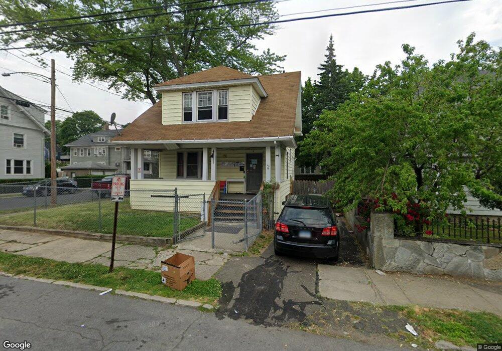
40 Hunting St Bridgeport, CT 06606
Brooklawn-Saint Vincent NeighborhoodEstimated Value: $358,000 - $399,000
3
Beds
1
Bath
1,256
Sq Ft
$295/Sq Ft
Est. Value
About This Home
This home is located at 40 Hunting St, Bridgeport, CT 06606 and is currently estimated at $370,226, approximately $294 per square foot. 40 Hunting St is a home located in Fairfield County with nearby schools including Read School, Central High School, and Catholic Academy of Bridgeport-St. Raphael Academy.
Ownership History
Date
Name
Owned For
Owner Type
Purchase Details
Closed on
Feb 1, 2001
Sold by
Miller William H
Bought by
Padilla Aisha M
Current Estimated Value
Home Financials for this Owner
Home Financials are based on the most recent Mortgage that was taken out on this home.
Original Mortgage
$89,200
Interest Rate
7.14%
Create a Home Valuation Report for This Property
The Home Valuation Report is an in-depth analysis detailing your home's value as well as a comparison with similar homes in the area
Home Values in the Area
Average Home Value in this Area
Purchase History
| Date | Buyer | Sale Price | Title Company |
|---|---|---|---|
| Padilla Aisha M | $90,000 | -- | |
| Padilla Aisha M | $90,000 | -- |
Source: Public Records
Mortgage History
| Date | Status | Borrower | Loan Amount |
|---|---|---|---|
| Open | Padilla Aisha M | $125,000 | |
| Closed | Padilla Aisha M | $89,200 | |
| Previous Owner | Padilla Aisha M | $140,000 |
Source: Public Records
Tax History Compared to Growth
Tax History
| Year | Tax Paid | Tax Assessment Tax Assessment Total Assessment is a certain percentage of the fair market value that is determined by local assessors to be the total taxable value of land and additions on the property. | Land | Improvement |
|---|---|---|---|---|
| 2025 | $5,701 | $131,210 | $63,430 | $67,780 |
| 2024 | $5,701 | $131,210 | $63,430 | $67,780 |
| 2023 | $5,701 | $131,210 | $63,430 | $67,780 |
| 2022 | $5,701 | $131,210 | $63,430 | $67,780 |
| 2021 | $5,701 | $131,210 | $63,430 | $67,780 |
| 2020 | $4,853 | $89,890 | $38,430 | $51,460 |
| 2019 | $4,853 | $89,890 | $38,430 | $51,460 |
| 2018 | $4,887 | $89,890 | $38,430 | $51,460 |
| 2017 | $4,887 | $89,890 | $38,430 | $51,460 |
| 2016 | $4,887 | $89,890 | $38,430 | $51,460 |
| 2015 | $4,709 | $111,590 | $38,750 | $72,840 |
| 2014 | $4,709 | $111,590 | $38,750 | $72,840 |
Source: Public Records
Map
Nearby Homes
- 936 Lindley St
- 926 Hart St
- 916 Hart St
- 1265 Lindley St
- 330 French St
- 39 Infield St
- 106 Manhattan Ave Unit 108
- 123 Harlem Ave
- 508 Hawley Ave
- 138 Infield St
- 45 Stevens St Unit 2
- 203 Wayne St
- 252 Harlem Ave Unit B6
- 252 Harlem Ave Unit B5
- 235 Indian Ave
- 234 Savoy St
- 245 Indian Ave
- 330 Oakwood St
- 119 Madison Terrace
- 2395 Main St Unit 2397
- 48 Hunting St
- 30 Hunting St
- 332 Gurdon St
- 331 Gurdon St Unit 333
- 60 Hunting St
- 18 Hunting St
- 342 Gurdon St
- 66 Hunting St
- 14 Hunting St
- 333 Gurdon St Unit 3
- 333 Gurdon St Unit 2
- 25 Hunting St Unit 25-27
- 25 Hunting St Unit 27
- 25 Hunting St Unit 1
- 25 Hunting St Unit 2
- 25 Hunting St Unit 3
- 25-27 Hunting St Unit 2
- 341 Gurdon St Unit 343
- 4 Hunting St
- 74 Hunting St Unit 76