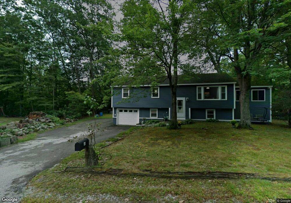
40 Oakwood Cir Milford, NH 03055
Estimated Value: $408,000 - $475,000
3
Beds
2
Baths
1,056
Sq Ft
$425/Sq Ft
Est. Value
About This Home
This home is located at 40 Oakwood Cir, Milford, NH 03055 and is currently estimated at $448,792, approximately $424 per square foot. 40 Oakwood Cir is a home with nearby schools including Jacques Memorial Elementary School, Heron Pond Elementary School, and Milford Middle School.
Ownership History
Date
Name
Owned For
Owner Type
Purchase Details
Closed on
Apr 17, 2024
Sold by
Herlihy Michael K and Herlihy Betty A
Bought by
Herlihy Ft and Herlihy
Current Estimated Value
Purchase Details
Closed on
Aug 24, 1998
Sold by
Gaspar John S
Bought by
Herlihy Michael K and Herlihy Betty A
Home Financials for this Owner
Home Financials are based on the most recent Mortgage that was taken out on this home.
Original Mortgage
$98,400
Interest Rate
6.86%
Create a Home Valuation Report for This Property
The Home Valuation Report is an in-depth analysis detailing your home's value as well as a comparison with similar homes in the area
Home Values in the Area
Average Home Value in this Area
Purchase History
| Date | Buyer | Sale Price | Title Company |
|---|---|---|---|
| Herlihy Ft | -- | None Available | |
| Herlihy Michael K | $107,000 | -- | |
| Herlihy Michael K | $107,000 | -- |
Source: Public Records
Mortgage History
| Date | Status | Borrower | Loan Amount |
|---|---|---|---|
| Previous Owner | Herlihy Michael K | $98,400 |
Source: Public Records
Tax History Compared to Growth
Tax History
| Year | Tax Paid | Tax Assessment Tax Assessment Total Assessment is a certain percentage of the fair market value that is determined by local assessors to be the total taxable value of land and additions on the property. | Land | Improvement |
|---|---|---|---|---|
| 2024 | $6,718 | $283,800 | $80,500 | $203,300 |
| 2023 | $6,292 | $283,800 | $80,500 | $203,300 |
| 2022 | $5,900 | $283,800 | $80,500 | $203,300 |
| 2021 | $5,719 | $283,800 | $80,500 | $203,300 |
| 2020 | $6,117 | $241,100 | $58,500 | $182,600 |
| 2019 | $6,261 | $241,100 | $58,500 | $182,600 |
| 2018 | $6,010 | $205,600 | $56,800 | $148,800 |
| 2017 | $6,043 | $205,600 | $56,800 | $148,800 |
| 2016 | $6,261 | $216,200 | $56,800 | $159,400 |
| 2015 | $6,046 | $211,700 | $56,800 | $154,900 |
| 2014 | $5,779 | $211,700 | $56,800 | $154,900 |
| 2013 | $5,402 | $200,300 | $56,800 | $143,500 |
Source: Public Records
Map
Nearby Homes
- 0 Claude Rd
- 40 North St
- 377 Nashua St
- 7 Fox Run Rd
- 2 Benning St
- 57 Patch Hill Ln
- 24 Spaulding St
- 44 Osgood Rd
- 7 Miles Rd
- 229 Mont Vernon Rd
- 61 W Meadow Ct
- 25 Atherton Ln
- 0 Briar Cliff Dr
- 6 Whittemore Ln
- 64 Lyndeborough Rd
- 135 Amherst St Unit 28
- 9 Northfield Rd
- 8 Carriage Ln
- 145 Westchester Dr
- 32 Larch Rd
- 44 Oakwood Cir
- 36 Oakwood Cir
- 29 Oakwood Cir
- 74 Souhegan St
- 44 Chestnut St
- 32 Oakwood Cir
- 37 Oakwood Cir
- 23 Oakwood Cir
- 30 Oakwood Cir
- 82 Souhegan St
- 68 Souhegan St
- 41 Oakwood Cir
- 26 Oakwood Cir
- 9 Oakwood Cir
- 19 Oakwood Cir
- 36 Chestnut St
- 12 Hilltop Dr
- 39 Chestnut St
- 71 Souhegan St Unit 2
- 71 Souhegan St