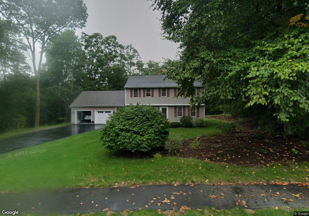
40 Randall Wood Dr Montague, MA 01351
Estimated Value: $438,000 - $478,000
3
Beds
6
Baths
1,872
Sq Ft
$244/Sq Ft
Est. Value
About This Home
This home is located at 40 Randall Wood Dr, Montague, MA 01351 and is currently estimated at $456,696, approximately $243 per square foot. 40 Randall Wood Dr is a home located in Franklin County.
Ownership History
Date
Name
Owned For
Owner Type
Purchase Details
Closed on
Dec 10, 2022
Sold by
Johnson Michael S and Johnson Amelie R
Bought by
Johnson Ft and Johnson
Current Estimated Value
Purchase Details
Closed on
Apr 18, 1997
Sold by
Kts Nt and Chevalier Daniel J
Bought by
Johnson Michael S and Johnson Amelie R
Create a Home Valuation Report for This Property
The Home Valuation Report is an in-depth analysis detailing your home's value as well as a comparison with similar homes in the area
Home Values in the Area
Average Home Value in this Area
Purchase History
| Date | Buyer | Sale Price | Title Company |
|---|---|---|---|
| Johnson Ft | -- | None Available | |
| Johnson Ft | -- | None Available | |
| Johnson Ft | -- | None Available | |
| Johnson Michael S | $120,000 | -- | |
| Johnson Michael S | $120,000 | -- |
Source: Public Records
Mortgage History
| Date | Status | Borrower | Loan Amount |
|---|---|---|---|
| Previous Owner | Johnson Michael S | $20,000 | |
| Previous Owner | Johnson Michael S | $208,000 |
Source: Public Records
Tax History Compared to Growth
Tax History
| Year | Tax Paid | Tax Assessment Tax Assessment Total Assessment is a certain percentage of the fair market value that is determined by local assessors to be the total taxable value of land and additions on the property. | Land | Improvement |
|---|---|---|---|---|
| 2025 | $5,845 | $384,300 | $71,100 | $313,200 |
| 2024 | $5,292 | $337,100 | $71,100 | $266,000 |
| 2023 | $5,149 | $329,000 | $71,100 | $257,900 |
| 2022 | $4,664 | $278,300 | $71,100 | $207,200 |
| 2021 | $5,343 | $261,600 | $58,900 | $202,700 |
| 2020 | $5,579 | $248,300 | $58,900 | $189,400 |
| 2019 | $4,241 | $247,600 | $65,800 | $181,800 |
| 2018 | $4,117 | $240,900 | $65,800 | $175,100 |
| 2017 | $5,555 | $240,900 | $65,800 | $175,100 |
| 2016 | $4,135 | $234,800 | $68,500 | $166,300 |
| 2015 | $3,982 | $234,800 | $68,500 | $166,300 |
| 2014 | $3,837 | $234,800 | $68,500 | $166,300 |
Source: Public Records
Map
Nearby Homes
- 38 Randall Wood Dr
- 55 A + B Randall Rd
- 114 Montague St
- 202 Turnpike Rd
- 89 Montague St
- 109 Montague City Rd
- 2 Alice St
- 183 Millers Falls Rd
- 45 Millers Falls Rd
- 0 Millers Falls Rd Unit 73034825
- 21 Hillside Ave
- 30 Park St
- 2 Orchard St
- 43 Crescent St
- 0 Marshall St
- 93 Maple St
- 30 Grinnell St
- 69 Madison Cir
- 10 Tulip Ln
- 73 Washington St
- 39 Randall Wood Dr
- 42 Randall Wood Dr
- 43 Randall Wood Dr
- 44 Randall Wood Dr
- 36 Randall Wood Dr
- 33 Randall Wood Dr
- 45 Randall Wood Dr
- 29 Randall Wood Dr
- 103 Greenfield Rd
- 46 Randall Wood Dr
- 47 Randall Wood Dr
- 27 Randall Wood Dr
- 34 Randall Wood Dr
- 25 Randall Wood Dr
- 49 Randall Wood Dr
- 30 Randall Wood Dr
- 23 Randall Wood Dr
- 50 Randall Wood Dr
- 51 Randall Wood Dr
- 26 Randall Wood Dr