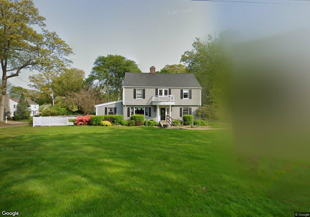
40 Ridgeway Rd Easton, CT 06612
Estimated Value: $1,158,000 - $1,280,000
4
Beds
5
Baths
4,279
Sq Ft
$283/Sq Ft
Est. Value
About This Home
This home is located at 40 Ridgeway Rd, Easton, CT 06612 and is currently estimated at $1,213,040, approximately $283 per square foot. 40 Ridgeway Rd is a home located in Fairfield County with nearby schools including Samuel Staples Elementary School, Helen Keller Middle School, and Joel Barlow High School.
Ownership History
Date
Name
Owned For
Owner Type
Purchase Details
Closed on
Sep 18, 2007
Sold by
Falke Ralph A and Falke Ann M
Bought by
Andrews William C and Andrews Beth Anne
Current Estimated Value
Purchase Details
Closed on
Apr 7, 2006
Sold by
Hubbard Thomas R and Hubbard Christina L
Bought by
Falke Ralph A and Falke M
Purchase Details
Closed on
Oct 16, 2000
Sold by
Garry William H and Garry Linda S
Bought by
Hubbard Thomas R and Hubbard Christina L
Purchase Details
Closed on
Jul 2, 1996
Sold by
Scinto Barbara
Bought by
Garry William H and Garry Linda S
Create a Home Valuation Report for This Property
The Home Valuation Report is an in-depth analysis detailing your home's value as well as a comparison with similar homes in the area
Home Values in the Area
Average Home Value in this Area
Purchase History
| Date | Buyer | Sale Price | Title Company |
|---|---|---|---|
| Andrews William C | $881,000 | -- | |
| Andrews William C | $881,000 | -- | |
| Falke Ralph A | $820,000 | -- | |
| Falke Ralph A | $820,000 | -- | |
| Hubbard Thomas R | $685,000 | -- | |
| Hubbard Thomas R | $685,000 | -- | |
| Garry William H | $470,000 | -- | |
| Garry William H | $470,000 | -- |
Source: Public Records
Mortgage History
| Date | Status | Borrower | Loan Amount |
|---|---|---|---|
| Open | Garry William H | $371,000 |
Source: Public Records
Tax History Compared to Growth
Tax History
| Year | Tax Paid | Tax Assessment Tax Assessment Total Assessment is a certain percentage of the fair market value that is determined by local assessors to be the total taxable value of land and additions on the property. | Land | Improvement |
|---|---|---|---|---|
| 2025 | $16,360 | $527,730 | $186,200 | $341,530 |
| 2024 | $15,589 | $527,730 | $186,200 | $341,530 |
| 2023 | $15,283 | $527,730 | $186,200 | $341,530 |
| 2022 | $15,009 | $527,730 | $186,200 | $341,530 |
| 2021 | $14,365 | $444,050 | $182,870 | $261,180 |
| 2020 | $13,766 | $444,050 | $182,870 | $261,180 |
| 2019 | $13,912 | $444,050 | $182,870 | $261,180 |
| 2018 | $13,934 | $444,050 | $182,870 | $261,180 |
| 2017 | $14,822 | $444,050 | $182,870 | $261,180 |
| 2016 | $12,948 | $420,250 | $182,880 | $237,370 |
| 2015 | $12,767 | $420,250 | $182,880 | $237,370 |
| 2014 | $12,565 | $420,250 | $182,880 | $237,370 |
Source: Public Records
Map
Nearby Homes
- 39 Sunset Rd
- 48 Sunset Rd
- 16 Manor Ln
- 305 Sport Hill Rd
- 38 Chester Rd
- 68 High Ridge Rd
- 63 Flat Rock Dr
- 35 Sturbridge Rd
- 93 Tersana Dr
- 83 Buck Hill Rd
- 32 Adirondack Trail
- 26 Wendy Rd
- 76 Hilary Cir Unit 76
- 42 Wendy Rd
- lot 194 Prospect Ave
- 178 Autumn Ridge Rd
- 71 Schiller Rd
- 132 Merrimac Dr
- 4293 Madison Ave
- 44 Lance Cir Unit 44