Estimated Value: $89,373 - $151,000
2
Beds
1
Bath
810
Sq Ft
$136/Sq Ft
Est. Value
About This Home
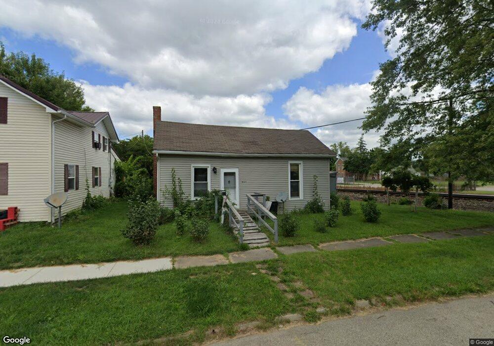
This home is located at 400 E Decatur St, Eaton, OH 45320 and is currently estimated at $110,343, approximately $136 per square foot. 400 E Decatur St is a home located in Preble County with nearby schools including Hollingsworth East Elementary School, William Bruce Elementary School, and Eaton Middle School.
Ownership History
Date
Name
Owned For
Owner Type
Purchase Details
Closed on
Mar 7, 2022
Sold by
Mitchell and Pauline
Bought by
Mitchell Wilmer and Mitchell Pauline
Current Estimated Value
Purchase Details
Closed on
Nov 21, 2000
Sold by
Philhower Larry
Bought by
Owens Gregory and Owens Annette
Home Financials for this Owner
Home Financials are based on the most recent Mortgage that was taken out on this home.
Original Mortgage
$23,300
Interest Rate
7.87%
Mortgage Type
New Conventional
Purchase Details
Closed on
Dec 9, 1997
Sold by
Elliott 4 Inc
Bought by
Conley Andrew J and Conley Susan M
Create a Home Valuation Report for This Property
The Home Valuation Report is an in-depth analysis detailing your home's value as well as a comparison with similar homes in the area
Home Values in the Area
Average Home Value in this Area
Purchase History
| Date | Buyer | Sale Price | Title Company |
|---|---|---|---|
| Mitchell Wilmer | -- | Ross Augustus L | |
| Owens Gregory | $37,000 | -- | |
| Conley Andrew J | $750 | -- |
Source: Public Records
Mortgage History
| Date | Status | Borrower | Loan Amount |
|---|---|---|---|
| Previous Owner | Owens Gregory | $23,300 |
Source: Public Records
Tax History
| Year | Tax Paid | Tax Assessment Tax Assessment Total Assessment is a certain percentage of the fair market value that is determined by local assessors to be the total taxable value of land and additions on the property. | Land | Improvement |
|---|---|---|---|---|
| 2025 | $687 | $16,950 | $4,380 | $12,570 |
| 2024 | $687 | $16,950 | $4,380 | $12,570 |
| 2023 | $680 | $16,950 | $4,380 | $12,570 |
| 2022 | $631 | $12,850 | $4,030 | $8,820 |
| 2021 | $659 | $12,850 | $4,030 | $8,820 |
| 2020 | $637 | $12,850 | $4,030 | $8,820 |
| 2019 | $562 | $10,990 | $3,360 | $7,630 |
| 2018 | $578 | $10,990 | $3,360 | $7,630 |
| 2017 | $547 | $10,990 | $3,360 | $7,630 |
| 2016 | $517 | $10,400 | $3,360 | $7,040 |
| 2014 | $509 | $10,400 | $3,360 | $7,040 |
| 2013 | $550 | $11,025 | $3,360 | $7,665 |
Source: Public Records
Map
Nearby Homes
- 600 E Somers St
- 0-00 Washington Jackson Rd
- 210 Mccabe St
- 130 E High St
- 115 E Decatur St
- 224 N Barron St
- 331 E Monfort St
- 117 Vine St
- 113 S Barron St
- 124 Deem St
- 216 S Franklin St
- 216 Vine St
- 900 N Maple St
- 230 W Decatur St
- 315 S Maple St
- 709 N Barron St Unit 711
- 415 East Ave
- 321 Liberty St
- 510 S Maple St
- 922 E High St
- 328 E Decatur St
- 320 E Decatur St
- 228 N Franklin St
- 228 N Franklin St
- 321 E Decatur St
- 315 E Decatur St
- 221 N Franklin St
- 221 N Franklin St
- 308 N Maple St
- 216 N Franklin St
- 216 1/2 N Franklin St
- 0 N Franklin St Unit 537375
- 217 N Franklin St
- 318 Lincoln St
- 222 N Maple St
- 0 Maple St Unit 1784582
- 216 N Maple St
- 226 N Maple St
- 324 Lincoln St
- 214 N Franklin St
Your Personal Tour Guide
Ask me questions while you tour the home.