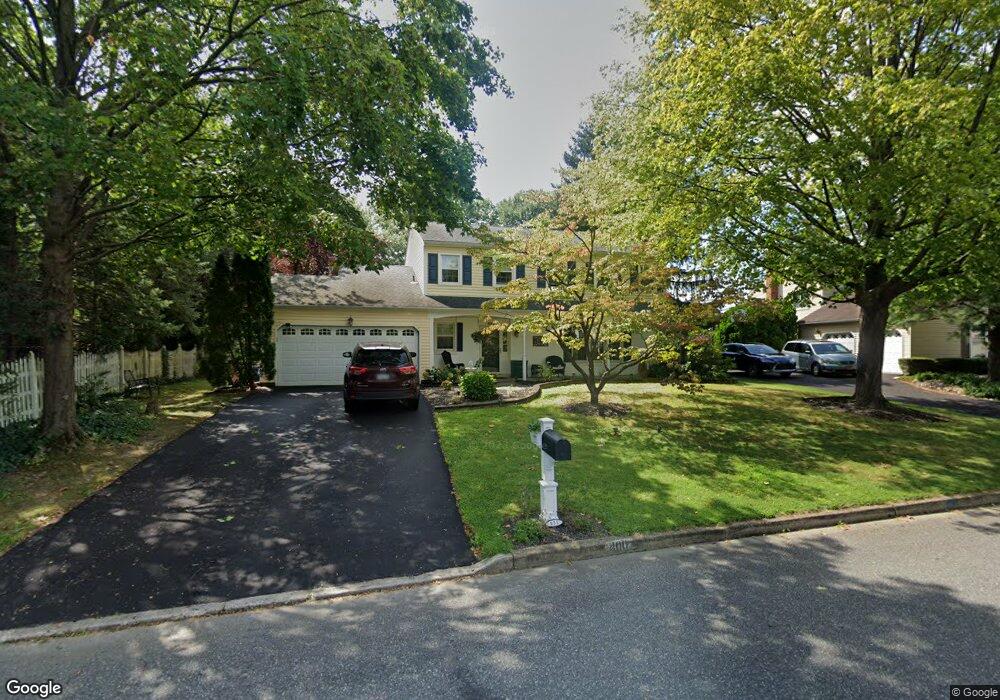
400 Maple Point Dr Langhorne, PA 19047
Estimated Value: $699,000 - $811,000
4
Beds
3
Baths
2,699
Sq Ft
$281/Sq Ft
Est. Value
About This Home
This home is located at 400 Maple Point Dr, Langhorne, PA 19047 and is currently estimated at $759,520, approximately $281 per square foot. 400 Maple Point Dr is a home located in Bucks County with nearby schools including Pearl S. Buck Elementary School, Maple Point Middle School, and Neshaminy High School.
Ownership History
Date
Name
Owned For
Owner Type
Purchase Details
Closed on
Aug 23, 1996
Sold by
Baker Joseph J and Baker Catherine Bradley
Bought by
Wishnow Jack S and Wishnow Susan E
Current Estimated Value
Home Financials for this Owner
Home Financials are based on the most recent Mortgage that was taken out on this home.
Original Mortgage
$154,500
Outstanding Balance
$12,180
Interest Rate
8.18%
Estimated Equity
$747,340
Purchase Details
Closed on
Oct 8, 1981
Bought by
Baker Jos J Jr
Create a Home Valuation Report for This Property
The Home Valuation Report is an in-depth analysis detailing your home's value as well as a comparison with similar homes in the area
Home Values in the Area
Average Home Value in this Area
Purchase History
| Date | Buyer | Sale Price | Title Company |
|---|---|---|---|
| Wishnow Jack S | $206,000 | -- | |
| Baker Jos J Jr | $98,200 | -- |
Source: Public Records
Mortgage History
| Date | Status | Borrower | Loan Amount |
|---|---|---|---|
| Open | Wishnow Jack S | $154,500 |
Source: Public Records
Tax History Compared to Growth
Tax History
| Year | Tax Paid | Tax Assessment Tax Assessment Total Assessment is a certain percentage of the fair market value that is determined by local assessors to be the total taxable value of land and additions on the property. | Land | Improvement |
|---|---|---|---|---|
| 2025 | $8,630 | $39,640 | $6,480 | $33,160 |
| 2024 | $8,630 | $39,640 | $6,480 | $33,160 |
| 2023 | $8,493 | $39,640 | $6,480 | $33,160 |
| 2022 | $8,270 | $39,640 | $6,480 | $33,160 |
| 2021 | $8,270 | $39,640 | $6,480 | $33,160 |
| 2020 | $8,171 | $39,640 | $6,480 | $33,160 |
| 2019 | $7,988 | $39,640 | $6,480 | $33,160 |
| 2018 | $7,842 | $39,640 | $6,480 | $33,160 |
| 2017 | $7,641 | $39,640 | $6,480 | $33,160 |
| 2016 | $7,641 | $39,640 | $6,480 | $33,160 |
| 2015 | $7,831 | $39,640 | $6,480 | $33,160 |
| 2014 | $7,831 | $39,640 | $6,480 | $33,160 |
Source: Public Records
Map
Nearby Homes
- 624 Lollard Ct
- 14303 Cornerstone Dr
- 462 Scott Ct
- 2602 Waterford Rd Unit 96
- 2007 Waterford Rd Unit 81
- 1948 Satter Ct
- 181 Fillmore Way
- 28130 Hickory Ln
- 195 Roosevelt Dr
- 30139 Hickory Ln
- 5801 Spruce Mill Dr Unit 450
- 164 Tyler Way
- 1749 Locust Dr
- 654A Woodford Ln
- 81 Lavender Dr
- 1651 Covington Rd Unit 26
- 647A Rose Hollow Dr Unit B
- 650 Bayberry Ln Unit U6
- 24 Tupelo Ln
- 30 Tupelo Ln
- 384 Maple Point Dr
- 361 Trappe Ln
- 329 Trappe Ln
- 249 Trappe Ln
- 281 Trappe Ln
- 217 Trappe Ln
- 368 Maple Point Dr
- 417 Maple Point Dr
- 201 Trappe Ln
- 385 Maple Point Dr
- 352 Maple Point Dr
- 393 Trappe Ln
- 185 Trappe Ln
- 10 Dilworth Ln
- 432 Maple Point Dr
- 344 Trappe Ln
- 328 Trappe Ln
- 376 Trappe Ln
- 312 Trappe Ln
- 248 Trappe Ln