Estimated Value: $308,000 - $432,000
3
Beds
2
Baths
1,386
Sq Ft
$259/Sq Ft
Est. Value
About This Home
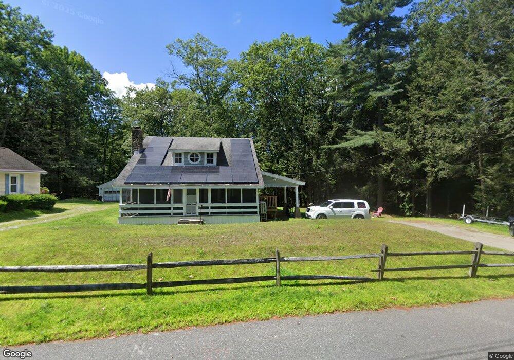
This home is located at 400 Pine Rd, Otis, MA 01253 and is currently estimated at $358,969, approximately $258 per square foot. 400 Pine Rd is a home with nearby schools including Farmington River Elementary School.
Ownership History
Date
Name
Owned For
Owner Type
Purchase Details
Closed on
Oct 30, 2023
Sold by
Hamre Jared M and Hamre Ashley
Bought by
Hamre Jared M
Current Estimated Value
Home Financials for this Owner
Home Financials are based on the most recent Mortgage that was taken out on this home.
Original Mortgage
$337,500
Outstanding Balance
$330,632
Interest Rate
7.18%
Mortgage Type
New Conventional
Estimated Equity
$28,337
Purchase Details
Closed on
May 6, 2022
Sold by
Belvedere Property Llc
Bought by
Hamre Jared M and Hamre Ashley
Create a Home Valuation Report for This Property
The Home Valuation Report is an in-depth analysis detailing your home's value as well as a comparison with similar homes in the area
Home Values in the Area
Average Home Value in this Area
Purchase History
| Date | Buyer | Sale Price | Title Company |
|---|---|---|---|
| Hamre Jared M | -- | None Available | |
| Hamre Jared M | -- | None Available | |
| Hamre Jared M | -- | None Available | |
| Hamre Jared M | $265,000 | None Available | |
| Hamre Jared M | $265,000 | None Available | |
| Hamre Jared M | $265,000 | None Available |
Source: Public Records
Mortgage History
| Date | Status | Borrower | Loan Amount |
|---|---|---|---|
| Open | Hamre Jared M | $337,500 | |
| Closed | Hamre Jared M | $337,500 |
Source: Public Records
Tax History
| Year | Tax Paid | Tax Assessment Tax Assessment Total Assessment is a certain percentage of the fair market value that is determined by local assessors to be the total taxable value of land and additions on the property. | Land | Improvement |
|---|---|---|---|---|
| 2025 | $1,367 | $211,600 | $66,000 | $145,600 |
| 2024 | $1,343 | $207,300 | $64,100 | $143,200 |
| 2023 | $1,225 | $185,100 | $41,900 | $143,200 |
| 2022 | $1,170 | $163,500 | $40,400 | $123,100 |
| 2021 | $1,170 | $138,100 | $40,400 | $97,700 |
| 2020 | $1,136 | $136,200 | $40,400 | $95,800 |
| 2019 | $1,128 | $136,200 | $40,400 | $95,800 |
| 2018 | $1,113 | $136,200 | $40,400 | $95,800 |
| 2017 | $1,100 | $136,200 | $40,400 | $95,800 |
| 2016 | $1,076 | $137,100 | $40,400 | $96,700 |
| 2015 | $1,066 | $141,600 | $37,700 | $103,900 |
Source: Public Records
Map
Nearby Homes
- 454 Pine Rd
- 134 Kibbe Rd
- 23 S Pine St
- 129 W Shore Rd
- 0 E Otis Rd Unit 73483991
- 0 Island Acres Rd Unit 73459836
- 1828 E Otis Rd
- 103 Algerie Rd
- 0 Curtis Hall Rd Unit 73425043
- 0 Curtis Hall Rd Unit 73376838
- 15B-7 E Otis Rd
- 0 Leisure Ln
- 0 Perry Rd
- 0 Lion Hill Rd
- 0 N Beech Plain Rd Unit 247823
- 303 Lakeshore Dr
- 314 & 316 Lakeshore Dr
- 93 S Main Rd
- 314 Lakeshore Dr
- 316 Lakeshore Dr
Your Personal Tour Guide
Ask me questions while you tour the home.