Estimated Value: $168,062 - $261,000
3
Beds
1
Bath
1,122
Sq Ft
$178/Sq Ft
Est. Value
About This Home
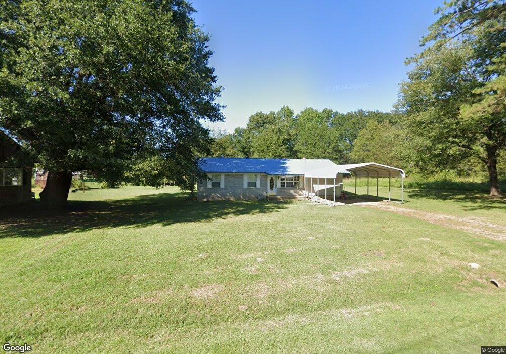
This home is located at 400 W Hancock St, Dyer, AR 72935 and is currently estimated at $199,687, approximately $177 per square foot. 400 W Hancock St is a home located in Crawford County with nearby schools including Alma Primary School, Alma Intermediate School, and Alma Middle School.
Ownership History
Date
Name
Owned For
Owner Type
Purchase Details
Closed on
Dec 9, 2022
Sold by
Vines Douglas E
Bought by
Pina-Jimenez Xitaly and Pina Rosalina
Current Estimated Value
Purchase Details
Closed on
Apr 13, 2015
Sold by
Morrell Bobby A and Morrell Thelma J
Bought by
Vines Douglas E
Home Financials for this Owner
Home Financials are based on the most recent Mortgage that was taken out on this home.
Original Mortgage
$56,700
Interest Rate
3.88%
Mortgage Type
New Conventional
Purchase Details
Closed on
Jun 24, 2005
Sold by
Warnock Wesley and Warnock Mary Sue
Bought by
Morrell Bobby A and Morrell Thelma J
Home Financials for this Owner
Home Financials are based on the most recent Mortgage that was taken out on this home.
Original Mortgage
$52,000
Interest Rate
5.76%
Mortgage Type
New Conventional
Purchase Details
Closed on
Aug 2, 1999
Bought by
Warnock-Warnock Trust
Create a Home Valuation Report for This Property
The Home Valuation Report is an in-depth analysis detailing your home's value as well as a comparison with similar homes in the area
Home Values in the Area
Average Home Value in this Area
Purchase History
| Date | Buyer | Sale Price | Title Company |
|---|---|---|---|
| Pina-Jimenez Xitaly | $135,000 | None Listed On Document | |
| Vines Douglas E | -- | None Available | |
| Morrell Bobby A | -- | -- | |
| Warnock-Warnock Trust | -- | -- |
Source: Public Records
Mortgage History
| Date | Status | Borrower | Loan Amount |
|---|---|---|---|
| Previous Owner | Vines Douglas E | $56,700 | |
| Previous Owner | Morrell Bobby A | $52,000 |
Source: Public Records
Tax History Compared to Growth
Tax History
| Year | Tax Paid | Tax Assessment Tax Assessment Total Assessment is a certain percentage of the fair market value that is determined by local assessors to be the total taxable value of land and additions on the property. | Land | Improvement |
|---|---|---|---|---|
| 2025 | $62 | $1,140 | $1,000 | $140 |
| 2024 | $62 | $1,140 | $1,000 | $140 |
| 2023 | $62 | $1,140 | $1,000 | $140 |
| 2022 | $70 | $1,280 | $1,000 | $280 |
| 2021 | $70 | $1,280 | $1,000 | $280 |
| 2020 | $70 | $1,280 | $1,000 | $280 |
| 2019 | $71 | $1,280 | $1,000 | $280 |
| 2018 | $71 | $1,280 | $1,000 | $280 |
| 2017 | $77 | $1,380 | $1,000 | $380 |
| 2016 | $77 | $1,380 | $1,000 | $380 |
| 2015 | $77 | $13,230 | $1,500 | $11,730 |
| 2014 | -- | $13,230 | $1,500 | $11,730 |
Source: Public Records
Map
Nearby Homes
- 223 S Main St
- 829 W Line St
- 205 N Main St
- TBD Goff Cir
- 2500 River Vista Dr
- 5801 Red Hill Rd
- 4725 Highway 64 E
- 2832 Tova Ln
- 3904 Golf Course Dr
- 3819 Tpc Dr
- 0 Lamb Rd
- 000 Lamb Rd
- TBD Industrial Park Dr
- TBD Exsorbet Dr
- 3525 Golf Course Dr
- 836 Eagle Crest Dr
- 3210 Osprey Cir
- 826 Eagle Crest Dr
- 1101 Eagle Crest Dr
- 3042 Mulberry Highway 64 W