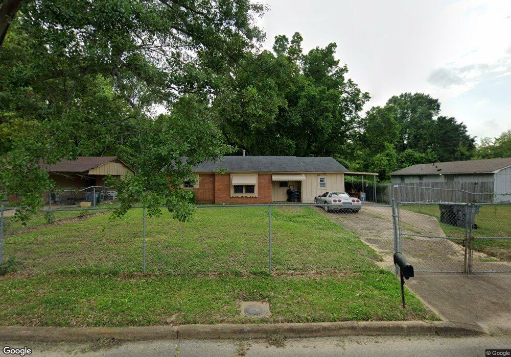
4007 Ebbtide St Memphis, TN 38109
Westwood NeighborhoodEstimated Value: $91,218 - $107,000
3
Beds
2
Baths
1,262
Sq Ft
$77/Sq Ft
Est. Value
About This Home
This home is located at 4007 Ebbtide St, Memphis, TN 38109 and is currently estimated at $97,055, approximately $76 per square foot. 4007 Ebbtide St is a home located in Shelby County with nearby schools including Levi Elementary School, Chickasaw Middle School, and Westwood High School.
Ownership History
Date
Name
Owned For
Owner Type
Purchase Details
Closed on
Jun 25, 2004
Sold by
Smith Sheila R
Bought by
Hudson Sank and Hudson Mary
Current Estimated Value
Home Financials for this Owner
Home Financials are based on the most recent Mortgage that was taken out on this home.
Original Mortgage
$60,500
Outstanding Balance
$35,237
Interest Rate
8.85%
Mortgage Type
Purchase Money Mortgage
Estimated Equity
$61,818
Purchase Details
Closed on
Feb 22, 2001
Sold by
Hudson Michael E
Bought by
Smith Sheila R
Home Financials for this Owner
Home Financials are based on the most recent Mortgage that was taken out on this home.
Original Mortgage
$50,150
Interest Rate
11.5%
Purchase Details
Closed on
Oct 16, 1998
Sold by
Sank Hudson and Sank Mary
Bought by
Hudson Michael Earl
Create a Home Valuation Report for This Property
The Home Valuation Report is an in-depth analysis detailing your home's value as well as a comparison with similar homes in the area
Home Values in the Area
Average Home Value in this Area
Purchase History
| Date | Buyer | Sale Price | Title Company |
|---|---|---|---|
| Hudson Sank | $60,500 | Equity Title & Escrow Co | |
| Smith Sheila R | $59,000 | -- | |
| Hudson Michael Earl | -- | -- |
Source: Public Records
Mortgage History
| Date | Status | Borrower | Loan Amount |
|---|---|---|---|
| Open | Hudson Sank | $60,500 | |
| Previous Owner | Smith Sheila R | $50,150 |
Source: Public Records
Tax History Compared to Growth
Tax History
| Year | Tax Paid | Tax Assessment Tax Assessment Total Assessment is a certain percentage of the fair market value that is determined by local assessors to be the total taxable value of land and additions on the property. | Land | Improvement |
|---|---|---|---|---|
| 2025 | $506 | $23,250 | $2,625 | $20,625 |
| 2024 | $506 | $14,925 | $2,050 | $12,875 |
| 2023 | $909 | $14,925 | $2,050 | $12,875 |
| 2022 | $909 | $14,925 | $2,050 | $12,875 |
| 2021 | $920 | $14,925 | $2,050 | $12,875 |
| 2020 | $824 | $11,375 | $2,050 | $9,325 |
| 2019 | $824 | $11,375 | $2,050 | $9,325 |
| 2018 | $824 | $11,375 | $2,050 | $9,325 |
| 2017 | $468 | $11,375 | $2,050 | $9,325 |
| 2016 | $497 | $11,375 | $0 | $0 |
| 2014 | $497 | $11,375 | $0 | $0 |
Source: Public Records
Map
Nearby Homes
- 330 Granville Ave
- 3953 Hedgerow Dr
- 4039 Trevathan Cir
- 3932 Dearborn St
- 3621 S 3rd St
- 4921 S Highway 61
- 4375 S Highway 61
- 0 S Third Unit 10199299
- 547 W Raines Rd
- 3804 Glenburee St
- 3807 Glenburee St
- 3829 Ford Rd
- 4227 Arrow Rd
- 0 Ford Rd
- 529 Deerskin Dr
- 648 Pawnee Ave
- 4335 Ford Rd
- 507 Tonto Rd
- 4334 Melwood St
- 646 Western Park Dr
- 4013 Ebbtide St
- 381 Lillian Dr
- 4019 Ebbtide St
- 4008 Ebbtide St
- 4027 Ebbtide St
- 4014 Ebbtide St
- 363 Lillian Dr
- 4020 Ebbtide St
- 384 Lillian Dr
- 378 Lillian Dr
- 1820 W Other
- 4033 Ebbtide St
- 370 Lillian Dr
- 366 Granville Ave
- 364 Lillian Dr
- 353 Lillian Dr
- 340 Leech Cove
- 360 Granville Ave
- 356 Lillian Dr
- 4002 Mccain Rd