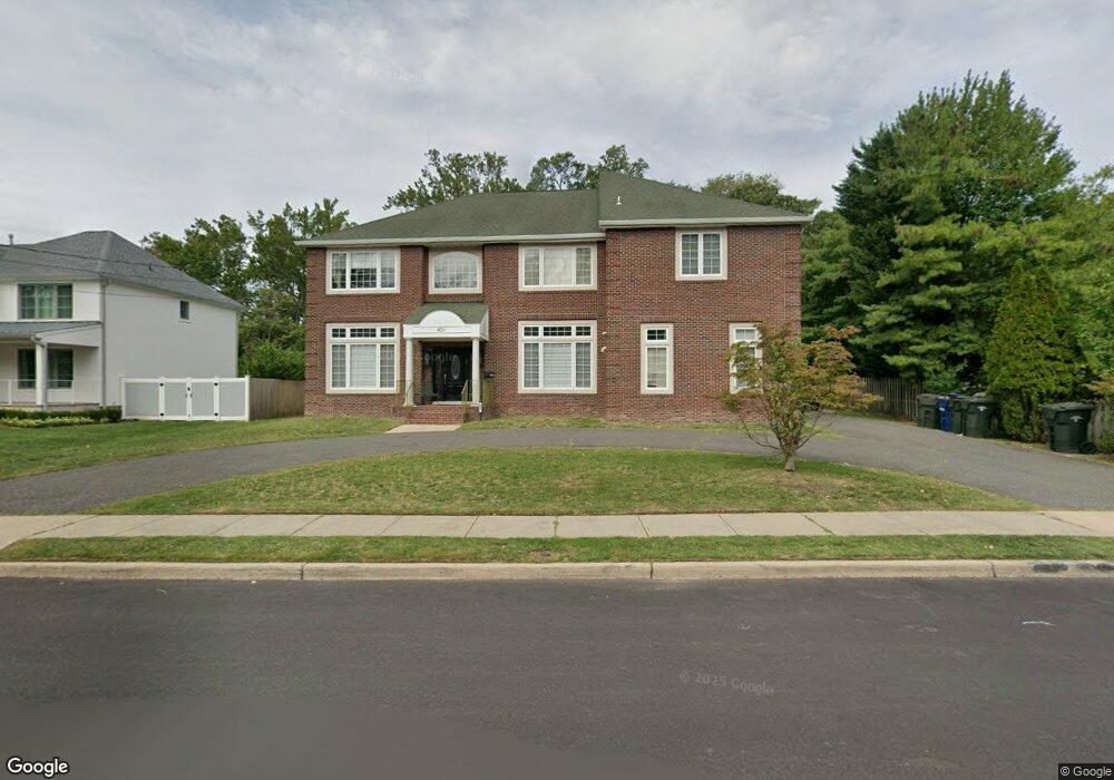
401 Brookside Ave Oakhurst, NJ 07755
Estimated Value: $1,544,674 - $2,581,000
5
Beds
4
Baths
4,584
Sq Ft
$455/Sq Ft
Est. Value
About This Home
This home is located at 401 Brookside Ave, Oakhurst, NJ 07755 and is currently estimated at $2,084,669, approximately $454 per square foot. 401 Brookside Ave is a home located in Monmouth County with nearby schools including Ocean Township High School, St. Mary of the Assumption School, and Bnot Shirah of Deal.
Ownership History
Date
Name
Owned For
Owner Type
Purchase Details
Closed on
Mar 11, 2008
Sold by
Stanziale Charles A and Dwek Solomon
Bought by
Sutton Max
Current Estimated Value
Home Financials for this Owner
Home Financials are based on the most recent Mortgage that was taken out on this home.
Original Mortgage
$504,000
Outstanding Balance
$330,605
Interest Rate
6.75%
Mortgage Type
Purchase Money Mortgage
Estimated Equity
$1,754,064
Purchase Details
Closed on
Apr 5, 2005
Sold by
Maxra Llc
Bought by
Dwek Solomon
Home Financials for this Owner
Home Financials are based on the most recent Mortgage that was taken out on this home.
Original Mortgage
$633,000
Interest Rate
5.71%
Mortgage Type
Purchase Money Mortgage
Purchase Details
Closed on
May 26, 1999
Sold by
Hoidal Mary
Bought by
Monmouth Plaza Llc
Create a Home Valuation Report for This Property
The Home Valuation Report is an in-depth analysis detailing your home's value as well as a comparison with similar homes in the area
Home Values in the Area
Average Home Value in this Area
Purchase History
| Date | Buyer | Sale Price | Title Company |
|---|---|---|---|
| Sutton Max | $630,000 | Tristar Title Group Llc | |
| Dwek Solomon | -- | -- | |
| Monmouth Plaza Llc | $30,000 | -- |
Source: Public Records
Mortgage History
| Date | Status | Borrower | Loan Amount |
|---|---|---|---|
| Open | Sutton Max | $504,000 | |
| Previous Owner | Dwek Solomon | $633,000 |
Source: Public Records
Tax History
| Year | Tax Paid | Tax Assessment Tax Assessment Total Assessment is a certain percentage of the fair market value that is determined by local assessors to be the total taxable value of land and additions on the property. | Land | Improvement |
|---|---|---|---|---|
| 2025 | $14,357 | $1,136,100 | $529,100 | $607,000 |
| 2024 | $15,619 | $1,006,800 | $510,200 | $496,600 |
| 2023 | $15,619 | $1,021,500 | $538,700 | $482,800 |
| 2022 | $13,533 | $824,000 | $357,900 | $466,100 |
| 2021 | $13,533 | $688,700 | $291,400 | $397,300 |
| 2020 | $13,155 | $660,700 | $267,000 | $393,700 |
| 2019 | $14,255 | $699,100 | $229,000 | $470,100 |
| 2018 | $13,695 | $654,000 | $200,500 | $453,500 |
| 2017 | $12,830 | $610,100 | $181,500 | $428,600 |
| 2016 | $12,172 | $520,600 | $162,400 | $358,200 |
| 2015 | $11,917 | $516,100 | $162,400 | $353,700 |
| 2014 | $12,470 | $547,400 | $191,100 | $356,300 |
Source: Public Records
Map
Nearby Homes
- 404 Brookside Ave
- 1 Country Club Dr
- 306 Roosevelt Ave
- 243 Woodcrest Rd
- 210 Larchwood Ave
- 232 Woodcrest Rd
- 409 Wells Ave
- 15 Joanna Ct
- 244 Overbrook Ave
- 450 Wells Ave
- 0 Overbrook Ave
- 185 Elmwood Rd
- 243 Overbrook Ave
- 227 Chatham Ave
- 187 Pinecrest Rd
- 267 Roosevelt Ave
- 201 Freehold St
- 185 Pinecrest Rd
- 274 Michael Ave
- 197 Delaware Ave
- 403 Brookside Ave
- 246 Monmouth Rd
- 394 Redmond Ave
- 396 Redmond Ave
- 409 Brookside Ave
- 250 Monmouth Rd
- 400 Brookside Ave
- 240 Monmouth Rd
- 240 Monmouth Rd
- 402 Redmond Ave
- 406 Brookside Ave
- 406 Redmond Ave
- 410 Brookside Ave
- 410 Redmond Ave
- 413 Brookside Ave
- 407 Redmond Ave
- 251 Monmouth Rd Unit B
- 251 Monmouth Rd Unit A
- 412 Brookside Ave
- 409 Redmond Ave
Your Personal Tour Guide
Ask me questions while you tour the home.