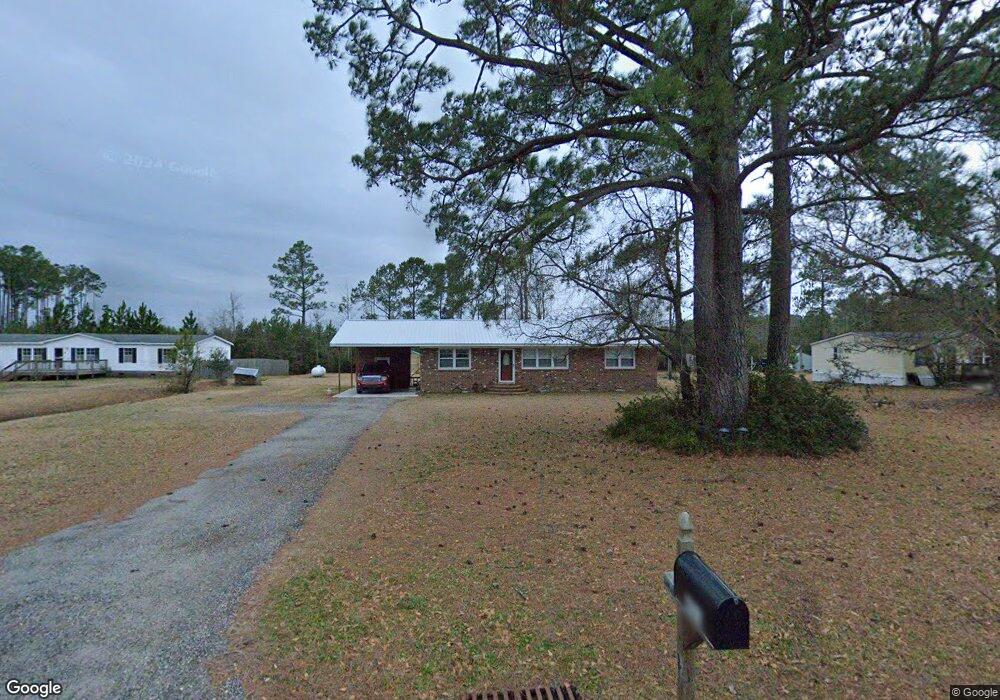
401 Hoover Rd Hampstead, NC 28443
Estimated Value: $281,399 - $336,000
3
Beds
2
Baths
1,344
Sq Ft
$227/Sq Ft
Est. Value
About This Home
This home is located at 401 Hoover Rd, Hampstead, NC 28443 and is currently estimated at $305,100, approximately $227 per square foot. 401 Hoover Rd is a home located in Pender County with nearby schools including South Topsail Elementary School, Topsail Middle School, and Topsail High School.
Ownership History
Date
Name
Owned For
Owner Type
Purchase Details
Closed on
Jul 31, 2006
Sold by
Morgan Earl David and Morgan Bonnie L
Bought by
Norman Kenneth C and Norman Kathleen S
Current Estimated Value
Home Financials for this Owner
Home Financials are based on the most recent Mortgage that was taken out on this home.
Original Mortgage
$104,000
Outstanding Balance
$8,320
Interest Rate
6.6%
Mortgage Type
New Conventional
Estimated Equity
$296,780
Create a Home Valuation Report for This Property
The Home Valuation Report is an in-depth analysis detailing your home's value as well as a comparison with similar homes in the area
Home Values in the Area
Average Home Value in this Area
Purchase History
| Date | Buyer | Sale Price | Title Company |
|---|---|---|---|
| Norman Kenneth C | $130,000 | -- |
Source: Public Records
Mortgage History
| Date | Status | Borrower | Loan Amount |
|---|---|---|---|
| Open | Norman Kenneth C | $104,000 |
Source: Public Records
Tax History Compared to Growth
Tax History
| Year | Tax Paid | Tax Assessment Tax Assessment Total Assessment is a certain percentage of the fair market value that is determined by local assessors to be the total taxable value of land and additions on the property. | Land | Improvement |
|---|---|---|---|---|
| 2024 | $1,473 | $137,630 | $29,310 | $108,320 |
| 2023 | $1,473 | $137,630 | $29,310 | $108,320 |
| 2022 | $1,366 | $137,630 | $29,310 | $108,320 |
| 2021 | $1,366 | $137,630 | $29,310 | $108,320 |
| 2020 | $1,322 | $132,363 | $29,310 | $103,053 |
| 2019 | $1,322 | $132,363 | $29,310 | $103,053 |
| 2018 | $845 | $71,651 | $11,500 | $60,151 |
| 2017 | $845 | $71,651 | $11,500 | $60,151 |
| 2016 | $838 | $71,651 | $11,500 | $60,151 |
| 2015 | $803 | $71,651 | $11,500 | $60,151 |
| 2014 | $653 | $71,651 | $11,500 | $60,151 |
| 2013 | -- | $71,651 | $11,500 | $60,151 |
| 2012 | -- | $71,651 | $11,500 | $60,151 |
Source: Public Records
Map
Nearby Homes
- 57 Downy Dr
- 23 Downy Dr
- 106 Starling Dr
- 97 Violetear Ridge
- 83 Thrush Trail
- 144 Violetear Ridge
- 11 Acacia Rd
- 148 Aspen Rd
- 97 Aspen Rd
- 203 Violetear Ridge
- 20 Aspen Rd
- Rosebay Plan at Brookfield Branch
- Fern Plan at Brookfield Branch
- Honeybird Plan at Brookfield Branch
- Hazel Plan at Brookfield Branch
- Alder Plan at Brookfield Branch
- 50 Cobbler Way Unit 50
- 68 Cobbler Way Unit 52
- 225 Factory Rd
- 83 Cobbler Way Unit 39
- 363 Hoover Rd
- 386 Hoover Rd
- 414 Hoover Rd
- 368 Hoover Rd
- 344 Hoover Rd
- 116 Norman Cir
- 321 Hoover Rd
- 52 Daffodil Dr
- 291 Hoover Rd
- 504 Hoover Rd
- 310 Hoover Rd
- 296 Hoover Rd
- 85 Renee Dr
- 279 Old White Marsh Rd
- 191 Downy Dr Unit Lot 142
- 213 Downy Dr Unit Lot 144
- 223 Downy Dr
- 179 Downy Dr Unit 141
- 203 Downy Dr
- 167 Downy Dr