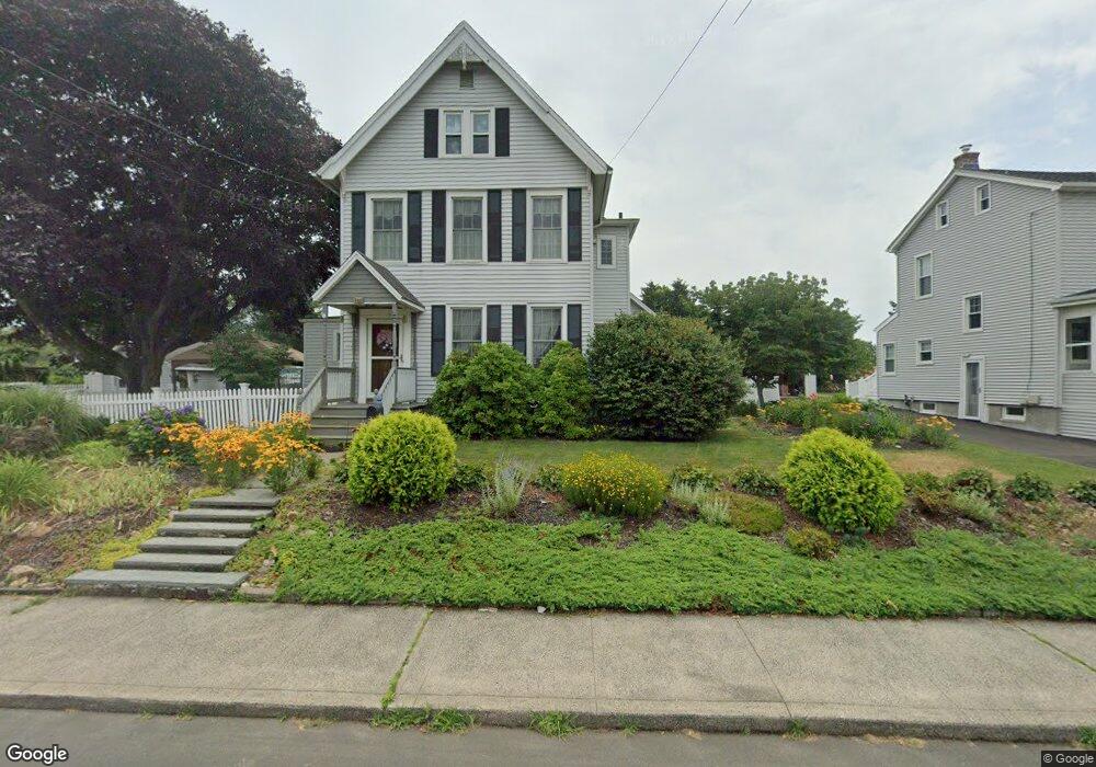
401 Lighthouse Rd New Haven, CT 06512
East Shore NeighborhoodEstimated Value: $473,193 - $612,000
4
Beds
3
Baths
2,453
Sq Ft
$218/Sq Ft
Est. Value
About This Home
This home is located at 401 Lighthouse Rd, New Haven, CT 06512 and is currently estimated at $534,298, approximately $217 per square foot. 401 Lighthouse Rd is a home located in New Haven County with nearby schools including Nathan Hale School, Elm City College Preparatory School, and All Saints Catholic Academy.
Ownership History
Date
Name
Owned For
Owner Type
Purchase Details
Closed on
Mar 10, 2016
Sold by
Grego William J and Grego Blanche P
Bought by
Wieser Elaina M and Mayo Michele M
Current Estimated Value
Purchase Details
Closed on
Nov 12, 1975
Bought by
Wieser Elaina M and Mayo Michele M
Create a Home Valuation Report for This Property
The Home Valuation Report is an in-depth analysis detailing your home's value as well as a comparison with similar homes in the area
Home Values in the Area
Average Home Value in this Area
Purchase History
| Date | Buyer | Sale Price | Title Company |
|---|---|---|---|
| Wieser Elaina M | -- | -- | |
| Wieser Elaina M | -- | -- |
Source: Public Records
Mortgage History
| Date | Status | Borrower | Loan Amount |
|---|---|---|---|
| Previous Owner | Wieser Elaina M | $117,260 | |
| Previous Owner | Wieser Elaina M | $85,000 |
Source: Public Records
Tax History
| Year | Tax Paid | Tax Assessment Tax Assessment Total Assessment is a certain percentage of the fair market value that is determined by local assessors to be the total taxable value of land and additions on the property. | Land | Improvement |
|---|---|---|---|---|
| 2025 | $9,438 | $239,540 | $71,820 | $167,720 |
| 2024 | $9,222 | $239,540 | $71,820 | $167,720 |
| 2023 | $8,911 | $239,540 | $71,820 | $167,720 |
| 2022 | $9,522 | $239,540 | $71,820 | $167,720 |
| 2021 | $7,851 | $178,920 | $46,620 | $132,300 |
| 2020 | $7,851 | $178,920 | $46,620 | $132,300 |
| 2019 | $7,690 | $178,920 | $46,620 | $132,300 |
| 2018 | $7,690 | $178,920 | $46,620 | $132,300 |
| 2017 | $6,921 | $178,920 | $46,620 | $132,300 |
| 2016 | $7,219 | $173,740 | $45,640 | $128,100 |
| 2015 | $7,219 | $173,740 | $45,640 | $128,100 |
| 2014 | $7,219 | $173,740 | $45,640 | $128,100 |
Source: Public Records
Map
Nearby Homes
- 119 Cove St
- 114 Cove St
- 86 Cove St
- 44 Meadow View Rd
- 506 Lighthouse Rd
- 19 Rhea St
- 48 Morris Ave
- 75 Townsend Ave
- 3 Stoddard Rd
- 15 Arden St
- 26 Nelson St
- 257 Concord St
- 166 Beach Ave
- 327 Concord St
- 560 Silver Sands Rd Unit 703
- 560 Silver Sands Rd Unit 1001
- 388 Concord St
- 63 Coleman St Unit 12
- 42 Oregon Ave
- 24 Woodward Ave Unit 46
- 411 Lighthouse Rd
- 397 Lighthouse Rd
- 340 Marion St
- 415 Lighthouse Rd
- 6 Constance St
- 334 Marion St
- 8 Constance St
- 387 Lighthouse Rd
- 328 Marion St
- 21 Anthony Dr
- 402 Lighthouse Rd
- 412 Lighthouse Rd
- 27 Anthony Dr
- 341 Marion St
- 15 Anthony Dr
- 416 Lighthouse Rd
- 392 Lighthouse Rd
- 392 Lighthouse Rd Unit 2
- 420 Lighthouse Rd
Your Personal Tour Guide
Ask me questions while you tour the home.