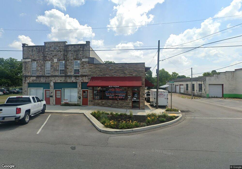
401 N 1st St Pulaski, TN 38478
Estimated Value: $158,368
--
Bed
--
Bath
700
Sq Ft
$226/Sq Ft
Est. Value
About This Home
This home is located at 401 N 1st St, Pulaski, TN 38478 and is currently estimated at $158,368, approximately $226 per square foot. 401 N 1st St is a home located in Giles County with nearby schools including Pulaski Elementary School, Southside Elementary School, and Bridgeforth Middle School.
Ownership History
Date
Name
Owned For
Owner Type
Purchase Details
Closed on
Apr 10, 2023
Sold by
Trigona Michael A
Bought by
Full Moon Properties Llc
Current Estimated Value
Purchase Details
Closed on
Feb 26, 2018
Sold by
Owens Thomas R
Bought by
Pylant Vernon and Cozart Sandra
Purchase Details
Closed on
Aug 6, 2014
Sold by
Wamble David
Bought by
Owens Thomas R
Purchase Details
Closed on
Dec 29, 2006
Sold by
Merritt John Michael
Bought by
Wamble David
Purchase Details
Closed on
Jan 15, 1992
Bought by
Merritt John
Purchase Details
Closed on
Sep 23, 1986
Bought by
Millican John L and Millican Donna
Create a Home Valuation Report for This Property
The Home Valuation Report is an in-depth analysis detailing your home's value as well as a comparison with similar homes in the area
Home Values in the Area
Average Home Value in this Area
Purchase History
| Date | Buyer | Sale Price | Title Company |
|---|---|---|---|
| Full Moon Properties Llc | -- | None Listed On Document | |
| Pylant Vernon | $46,000 | Title And Escrow Llc | |
| Owens Thomas R | $35,000 | -- | |
| Wamble David | $32,000 | -- | |
| Merritt John | $15,000 | -- | |
| Millican John L | -- | -- |
Source: Public Records
Tax History Compared to Growth
Tax History
| Year | Tax Paid | Tax Assessment Tax Assessment Total Assessment is a certain percentage of the fair market value that is determined by local assessors to be the total taxable value of land and additions on the property. | Land | Improvement |
|---|---|---|---|---|
| 2024 | $521 | $21,640 | $2,400 | $19,240 |
| 2023 | $521 | $21,640 | $2,400 | $19,240 |
| 2022 | $521 | $21,640 | $2,400 | $19,240 |
| 2021 | $686 | $20,240 | $2,400 | $17,840 |
| 2020 | $686 | $20,240 | $2,400 | $17,840 |
| 2019 | $363 | $16,120 | $2,400 | $13,720 |
| 2018 | $435 | $16,120 | $2,400 | $13,720 |
| 2017 | $435 | $12,840 | $2,400 | $10,440 |
| 2016 | $464 | $13,080 | $2,600 | $10,480 |
| 2015 | $437 | $13,080 | $2,600 | $10,480 |
| 2014 | $437 | $13,089 | $0 | $0 |
Source: Public Records
Map
Nearby Homes
- 116 E Woodring St
- 124 Chestnut St
- 418 Jones St
- 600 Childers St
- 321 W Washington St
- 617 Childers St
- 318 W Jefferson St
- 320 Park St
- 0 Sumpter St
- 613 Mcgrew St
- 403 Victoria St
- 118 S Rhodes St
- 808 N 1st St
- 219 W Flower St
- 528 Maple St
- 140 Phillips St
- 439 E Madison St
- 123 S Sam Davis Ave
- 0 Marietta St
- 630 Marietta St