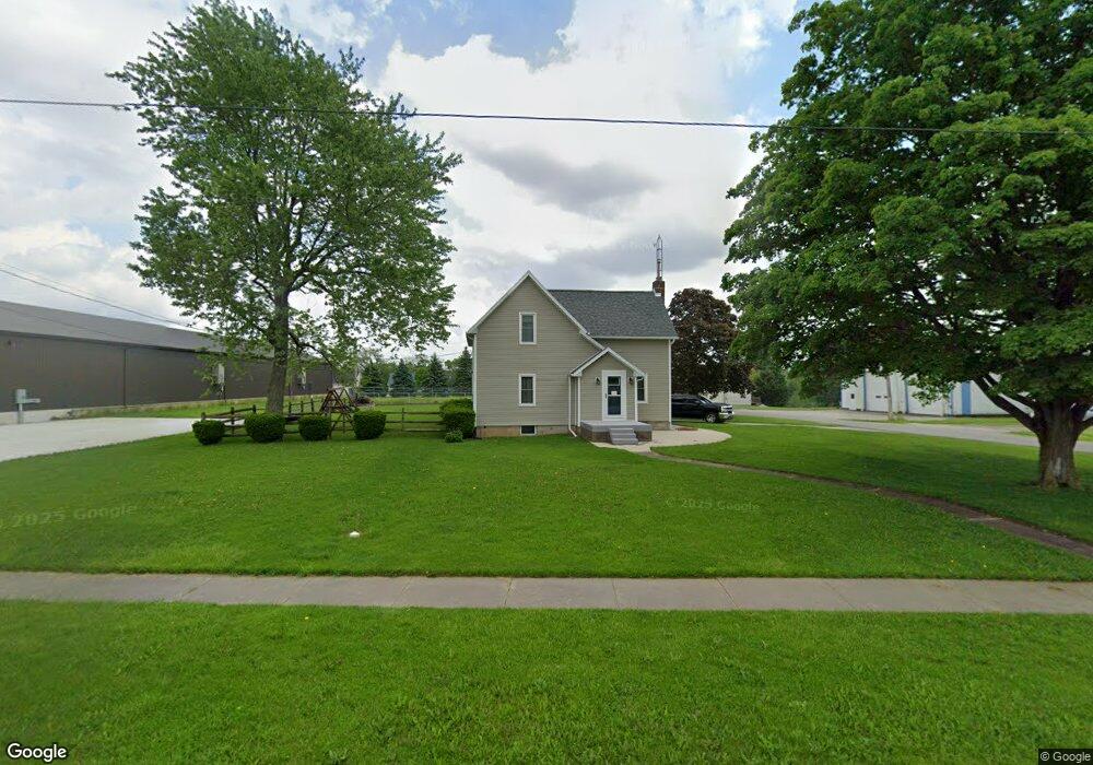
401 N Hill St Napoleon, OH 43545
Estimated Value: $157,000 - $215,115
4
Beds
2
Baths
1,840
Sq Ft
$98/Sq Ft
Est. Value
About This Home
This home is located at 401 N Hill St, Napoleon, OH 43545 and is currently estimated at $180,029, approximately $97 per square foot. 401 N Hill St is a home located in Henry County with nearby schools including Napoleon Elementary School and Napoleon Junior/Senior High School.
Ownership History
Date
Name
Owned For
Owner Type
Purchase Details
Closed on
May 10, 2017
Sold by
Bullock Estel D and Bullock Sara E
Bought by
Bullock Estel D and The Estel D Bullock Trust
Current Estimated Value
Purchase Details
Closed on
Dec 3, 2003
Sold by
Durham Harry H and Durham Rose Marie
Bought by
Bullock Estel D and Bullock Anne L
Home Financials for this Owner
Home Financials are based on the most recent Mortgage that was taken out on this home.
Original Mortgage
$80,000
Interest Rate
6.1%
Mortgage Type
Purchase Money Mortgage
Create a Home Valuation Report for This Property
The Home Valuation Report is an in-depth analysis detailing your home's value as well as a comparison with similar homes in the area
Home Values in the Area
Average Home Value in this Area
Purchase History
| Date | Buyer | Sale Price | Title Company |
|---|---|---|---|
| Bullock Estel D | -- | Attorney | |
| Bullock Estel D | $100,000 | -- |
Source: Public Records
Mortgage History
| Date | Status | Borrower | Loan Amount |
|---|---|---|---|
| Closed | Bullock Estel D | $80,000 | |
| Closed | Bullock Estel D | $10,000 |
Source: Public Records
Tax History Compared to Growth
Tax History
| Year | Tax Paid | Tax Assessment Tax Assessment Total Assessment is a certain percentage of the fair market value that is determined by local assessors to be the total taxable value of land and additions on the property. | Land | Improvement |
|---|---|---|---|---|
| 2024 | $1,909 | $44,500 | $7,900 | $36,600 |
| 2023 | $1,909 | $44,500 | $7,900 | $36,600 |
| 2022 | $2,145 | $87,520 | $9,880 | $77,640 |
| 2021 | $2,140 | $43,760 | $4,940 | $38,820 |
| 2020 | $2,110 | $43,760 | $4,940 | $38,820 |
| 2019 | $2,052 | $38,630 | $4,700 | $33,930 |
| 2018 | $2,079 | $38,630 | $4,700 | $33,930 |
| 2017 | $2,012 | $38,630 | $4,700 | $33,930 |
| 2016 | $1,753 | $32,450 | $4,700 | $27,750 |
| 2015 | $1,837 | $32,450 | $4,700 | $27,750 |
| 2014 | $1,837 | $32,450 | $4,700 | $27,750 |
| 2013 | $1,837 | $32,450 | $4,700 | $27,750 |
Source: Public Records
Map
Nearby Homes
- 405 W High St
- 212 E High St
- 16052 State Route 424
- H011 County Road 17
- 6767 Independence Rd
- 75 Capri Dr
- 43 Oak Dr
- 00 County Road 14
- 29232 Coressel Rd
- 0 Westmoreland Ave
- 29432 State Route 18
- 00 Westmoreland Ave
- 1374 Clairmont Ave
- 900 Welsted St
- 1113 Clairmont Ave
- 1314 Clairmont Ave
- 707 Park St
- 1214 Clairmont Ave
- 1354 Clairmont Ave
- 725 Sheffield Ave
- TBD Hill St
- 402 W School St
- 304 W School St
- 405 Church St
- 302 W School St
- 2 Michaelis Dr
- 1 Michaelis Dr
- 307 Church St
- 0 Michaelis Dr Unit 5016049
- 0 Michaelis Dr Unit 6103354
- 3 Michaelis Dr
- 203 N Canal St
- 105 Market St
- 302 Michaelis Dr
- 304 Michaelis Dr
- 201 N Canal St
- 306 Michaelis Dr
- 306 Church St
- 204 N Canal St
- 304 Church St