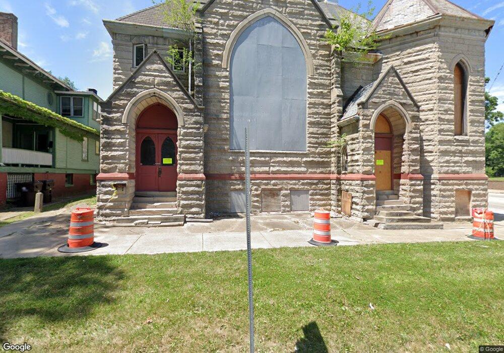
401 W High St Peoria, IL 61606
West Bluff NeighborhoodEstimated Value: $31,197
1
Bed
1
Bath
3,910
Sq Ft
$8/Sq Ft
Est. Value
About This Home
This home is located at 401 W High St, Peoria, IL 61606 and is currently estimated at $31,197, approximately $7 per square foot. 401 W High St is a home located in Peoria County with nearby schools including Peoria High School, Quest Charter School Academy, and St Mark School.
Ownership History
Date
Name
Owned For
Owner Type
Purchase Details
Closed on
Jul 2, 2024
Sold by
Kdb Group Llc
Bought by
City Of Peoria
Current Estimated Value
Purchase Details
Closed on
Jul 9, 2021
Sold by
Michelle Staker Amy
Bought by
Kdb Group Llc
Purchase Details
Closed on
May 26, 2021
Sold by
North Illinois Investments Llc
Bought by
Staker Amy Michelle and Carpenter Colby
Purchase Details
Closed on
Oct 8, 2020
Sold by
Trust No 18-04-351-024
Bought by
North Illinois Investments Llc
Purchase Details
Closed on
Aug 3, 2020
Sold by
County Clerk / County / Peoria
Bought by
Trust No 18-04-351-024 and Peoria County
Purchase Details
Closed on
Aug 10, 2011
Bought by
Huff Merle G and Murphy Earl P
Create a Home Valuation Report for This Property
The Home Valuation Report is an in-depth analysis detailing your home's value as well as a comparison with similar homes in the area
Home Values in the Area
Average Home Value in this Area
Purchase History
| Date | Buyer | Sale Price | Title Company |
|---|---|---|---|
| City Of Peoria | -- | None Listed On Document | |
| Kdb Group Llc | $25,000 | None Listed On Document | |
| Staker Amy Michelle | $20,700 | None Listed On Document | |
| North Illinois Investments Llc | -- | Schrimpf Stephen P | |
| Trust No 18-04-351-024 | -- | None Listed On Document | |
| Huff Merle G | $5,900 | -- |
Source: Public Records
Tax History Compared to Growth
Tax History
| Year | Tax Paid | Tax Assessment Tax Assessment Total Assessment is a certain percentage of the fair market value that is determined by local assessors to be the total taxable value of land and additions on the property. | Land | Improvement |
|---|---|---|---|---|
| 2024 | -- | -- | -- | -- |
| 2023 | $581 | $6,180 | $6,180 | -- |
| 2022 | $592 | $6,140 | $6,140 | $0 |
| 2021 | $698 | $7,020 | $5,850 | $1,170 |
| 2020 | $696 | $6,950 | $5,790 | $1,160 |
| 2019 | $706 | $7,090 | $5,910 | $1,180 |
| 2017 | $691 | $7,170 | $5,970 | $1,200 |
| 2016 | $672 | $7,170 | $5,970 | $1,200 |
| 2015 | $646 | $7,030 | $5,850 | $1,180 |
| 2014 | $646 | $7,020 | $5,850 | $1,170 |
| 2013 | -- | $7,100 | $5,920 | $1,180 |
Source: Public Records
Map
Nearby Homes
- 429 W High St
- 1216 N North St
- 1312 N Ellis St
- 1313 N Ellis St
- 1224 N Douglas St
- 401 W Armstrong Ave
- 609 W Armstrong Ave
- 816 W Columbia Terrace
- 1410 N Douglas St
- 919 W Windom St
- 911 W Russell St
- 710 W Armstrong Ave
- 919 W Moss Ave
- 1504 N Linn St
- 1402 N Broadway St
- 1415 N Broadway St
- 1624 N Bigelow St
- 1009 W Armstrong Ave
- 1112 W Columbia Terrace
- 125 SW Jefferson Ave Unit W4W
- 416 W Main St Unit B
- 416 W Main St Unit A
- 416 W Main St
- 405 W High St
- 413 W Main St
- 409 W Main St
- 423 W High St
- 427 W Main St Unit 2
- 427 W Main St
- 1101 and 1111 Main St
- 1101 & 1111 Main St
- 1012 N Flora Ave
- 1010 N Flora Ave
- 1101 N North St
- 1005 N Flora Ave
- 100 NE Randolph Ave
- 1101 Main St
- 502 W High St
- 1101 Main St
- 437 W High St