Estimated Value: $817,943 - $985,000
4
Beds
2
Baths
1,949
Sq Ft
$452/Sq Ft
Est. Value
About This Home
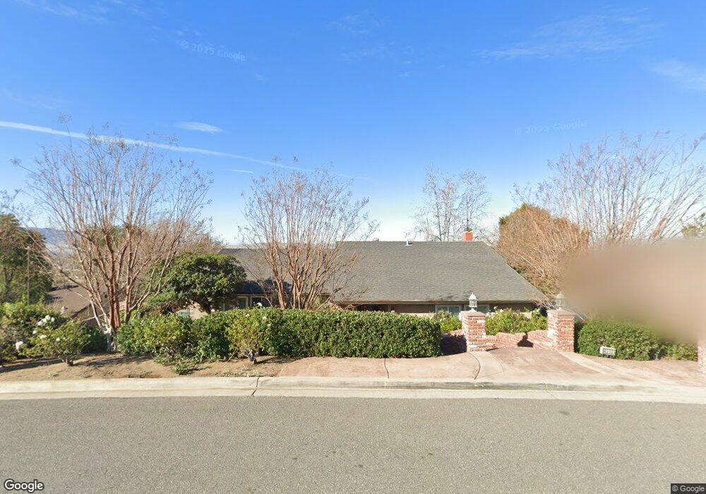
This home is located at 4010 Pikes Peak Dr, Norco, CA 92860 and is currently estimated at $881,236, approximately $452 per square foot. 4010 Pikes Peak Dr is a home located in Riverside County with nearby schools including Riverview Elementary School, Norco Intermediate School, and Norco High School.
Ownership History
Date
Name
Owned For
Owner Type
Purchase Details
Closed on
Sep 20, 2018
Sold by
Saugstad Carol L
Bought by
Saugstad Carol L
Current Estimated Value
Purchase Details
Closed on
May 28, 2015
Sold by
Saugstad Raynold Dale and Saugstad Carol Lynn
Bought by
Saugstad Raynold Dale and Saugstad Carol Lynn
Purchase Details
Closed on
Nov 17, 2009
Sold by
Saugstad Raynold Dale and Saugstad Carol Lynn
Bought by
Saugstad Raynold Dale and Saugstad Carol Lynn
Create a Home Valuation Report for This Property
The Home Valuation Report is an in-depth analysis detailing your home's value as well as a comparison with similar homes in the area
Home Values in the Area
Average Home Value in this Area
Purchase History
| Date | Buyer | Sale Price | Title Company |
|---|---|---|---|
| Saugstad Carol L | -- | None Available | |
| Saugstad Raynold Dale | -- | None Available | |
| Saugstad Raynold Dale | -- | None Available |
Source: Public Records
Tax History Compared to Growth
Tax History
| Year | Tax Paid | Tax Assessment Tax Assessment Total Assessment is a certain percentage of the fair market value that is determined by local assessors to be the total taxable value of land and additions on the property. | Land | Improvement |
|---|---|---|---|---|
| 2025 | $2,096 | $197,578 | $44,384 | $153,194 |
| 2023 | $2,096 | $189,908 | $42,661 | $147,247 |
| 2022 | $2,027 | $186,185 | $41,825 | $144,360 |
| 2021 | $1,984 | $182,535 | $41,005 | $141,530 |
| 2020 | $1,962 | $180,664 | $40,585 | $140,079 |
| 2019 | $1,915 | $177,123 | $39,790 | $137,333 |
| 2018 | $1,869 | $173,651 | $39,011 | $134,640 |
| 2017 | $1,821 | $170,247 | $38,247 | $132,000 |
| 2016 | $1,800 | $166,910 | $37,498 | $129,412 |
| 2015 | $1,760 | $164,405 | $36,936 | $127,469 |
| 2014 | $1,694 | $161,186 | $36,213 | $124,973 |
Source: Public Records
Map
Nearby Homes
- 111 Mount Rushmore Dr
- 4210 Crestview Dr
- 4131 California Ave
- 3547 Southfork Dr
- 3700 California Ave
- 4565 Crestview Dr
- 4566 Crestview Dr
- 3260 Crestview Dr
- 141 8th St
- 276 Pompano Place
- 397 8th St
- 3140 Stable Way
- 3081 Cavaletti Ln
- 4125 Center Ave
- 3475 Hillside Ave
- 4488 Hillside Ave
- 0 California Ave
- 4234 Center Ave
- 4174 Center Ave
- 379 North Dr
- 222 Mount Shasta Dr
- 4000 Pikes Peak Dr
- 4011 Mount Tobin Ct
- 4011 Pikes Peak Dr
- 4001 Pikes Peak Dr
- 0 Mt Tobin Unit OC18186843
- 0 Mt Tobin Unit OC18081492
- 0 Mt Tobin Unit OC19199294
- 0 Mt Tobin Unit OC19099234
- 0 Mt Tobin Unit OC19009942
- 0 Mt Tobin Unit OC18247288
- 221 Mount Shasta Dr
- 0 Mount Shasta Dr Unit K08126959
- 0 Mt Shasta Dr Unit CV16767279
- 0 Mount Shasta Dr Unit CV20027760
- 4000 Mount Tobin Ct
- 217 Mount Shasta Dr
- 0 Mount Tobin Ct
- 4022 Mount Ingalls Ct
- 4042 Mount Ingalls Ct