Estimated Value: $315,584 - $418,000
Studio
3
Baths
3,119
Sq Ft
$120/Sq Ft
Est. Value
About This Home
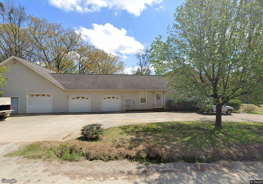
This home is located at 4010 Upper River Rd, Gray, GA 31032 and is currently estimated at $375,646, approximately $120 per square foot. 4010 Upper River Rd is a home located in Jones County with nearby schools including Dames Ferry Elementary School, Clifton Ridge Middle School, and Jones County High School.
Ownership History
Date
Name
Owned For
Owner Type
Purchase Details
Closed on
Aug 5, 2005
Sold by
Kunselman David J
Bought by
Kunselman David J and Kunselman Patricia Anne
Current Estimated Value
Home Financials for this Owner
Home Financials are based on the most recent Mortgage that was taken out on this home.
Original Mortgage
$126,000
Interest Rate
5.48%
Mortgage Type
New Conventional
Purchase Details
Closed on
Jul 29, 2005
Sold by
Hack Russell D
Bought by
Kunselman David J
Home Financials for this Owner
Home Financials are based on the most recent Mortgage that was taken out on this home.
Original Mortgage
$126,000
Interest Rate
5.48%
Mortgage Type
New Conventional
Purchase Details
Closed on
Mar 20, 2000
Sold by
Hack Deana S
Bought by
Hack Russell D
Create a Home Valuation Report for This Property
The Home Valuation Report is an in-depth analysis detailing your home's value as well as a comparison with similar homes in the area
Home Values in the Area
Average Home Value in this Area
Purchase History
| Date | Buyer | Sale Price | Title Company |
|---|---|---|---|
| Kunselman David J | -- | -- | |
| Kunselman David J | $250,000 | -- | |
| Hack Russell D | $24,000 | -- |
Source: Public Records
Mortgage History
| Date | Status | Borrower | Loan Amount |
|---|---|---|---|
| Closed | Kunselman David J | $126,000 |
Source: Public Records
Tax History
| Year | Tax Paid | Tax Assessment Tax Assessment Total Assessment is a certain percentage of the fair market value that is determined by local assessors to be the total taxable value of land and additions on the property. | Land | Improvement |
|---|---|---|---|---|
| 2025 | $4,625 | $144,689 | $6,696 | $137,993 |
| 2023 | $2,163 | $81,681 | $4,464 | $77,217 |
| 2022 | $2,793 | $81,458 | $4,241 | $77,217 |
| 2021 | $2,796 | $81,458 | $4,241 | $77,217 |
| 2020 | $2,798 | $81,458 | $4,241 | $77,217 |
| 2019 | $2,798 | $81,458 | $4,241 | $77,217 |
| 2018 | $2,798 | $81,458 | $4,241 | $77,217 |
| 2017 | $3,531 | $101,835 | $4,241 | $97,594 |
| 2016 | $3,531 | $101,835 | $4,241 | $97,594 |
| 2015 | $3,749 | $113,936 | $4,771 | $109,166 |
| 2014 | $3,457 | $113,936 | $4,771 | $109,166 |
Source: Public Records
Map
Nearby Homes
- 377 Plentitude Church Rd
- 4156 Upper River (Lots 15 & 16) Rd
- 238 Brittany Ln
- 4156 Upper River Rd
- 4156 Upper River Rd Unit LOT 15 &16
- 4477 Rivercliff Way
- 4481 Rivercliff Way
- 4450 Rivercliff Way
- 281 River Blvd N
- 159 River North Blvd
- 161 Fairway Cir
- 616 Whispering Pines Dr
- 417 Lakeview Place
- 4255 Upper River Rd
- 279 River North Blvd
- 124 Coppergate Ln
- 214 River North Cir
- 326 Wimbledon Ct
- 363 River North Blvd
- 432 River North Blvd
- 838 Mckay Rd
- 826 Mckay Rd
- 823 Mckay Rd
- 4026 Upper River Rd
- 3994 Upper River Rd
- 4032 Upper River Rd
- 814 Mckay Rd
- 4038 Upper River Rd
- 3986 Upper River Rd
- 13 Upper River
- 4035 Upper River Rd
- 800 Mckay Rd
- 4048 Upper River Rd
- 798 Mckay Rd
- 4054 Upper River Rd
- 787 Mckay Rd
- 4053 Upper River Rd
- 4057 Upper River Rd
- 786 Mckay Rd
- 4066 Upper River Rd
Your Personal Tour Guide
Ask me questions while you tour the home.