
Seller's Agent in 2025
Bill Alvin
Epique Realty
(810) 275-5195
3 in this area
167 Total Sales
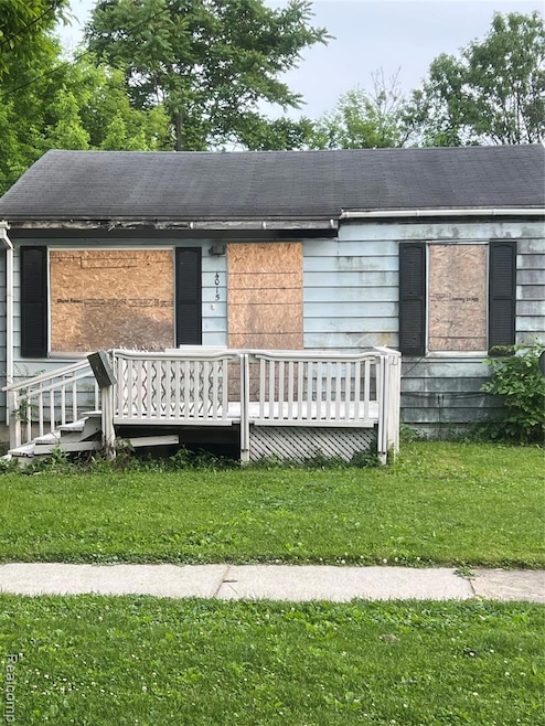
Great Opportunity – Full Renovation Project!
This 2-bedroom, 1-bath home is ready for a full renovation and packed with potential. Whether you're looking to create your forever home or add a strong performer to your rental portfolio, this property is a smart investment.
Located in a solid neighborhood
Plenty of upside with sweat equity
Ideal for investors, flippers, or first-time buyers ready to renovate
Bring your vision and turn this diamond in the rough into something special.
Priced to move—don’t miss out on this opportunity!
batvai
| Date | Type | Sale Price | Title Company |
|---|---|---|---|
| Warranty Deed | $10,000 | Dream Title & Escrow | |
| Quit Claim Deed | $8,000 | None Available | |
| Land Contract | $8,000 | None Available | |
| Quit Claim Deed | -- | None Available |
| Date | Status | Loan Amount | Loan Type |
|---|---|---|---|
| Closed | $0 | Seller Take Back |
| Date | Event | Price | List to Sale | Price per Sq Ft |
|---|---|---|---|---|
| 07/30/2025 07/30/25 | Sold | $10,000 | -12.3% | $14 / Sq Ft |
| 07/30/2025 07/30/25 | Pending | -- | -- | -- |
| 07/14/2025 07/14/25 | Price Changed | $11,400 | -4.2% | $16 / Sq Ft |
| 07/11/2025 07/11/25 | Price Changed | $11,900 | -7.8% | $17 / Sq Ft |
| 07/07/2025 07/07/25 | Price Changed | $12,900 | -7.2% | $18 / Sq Ft |
| 06/30/2025 06/30/25 | Price Changed | $13,900 | -6.7% | $20 / Sq Ft |
| 06/24/2025 06/24/25 | For Sale | $14,900 | -- | $21 / Sq Ft |
| Year | Tax Paid | Tax Assessment Tax Assessment Total Assessment is a certain percentage of the fair market value that is determined by local assessors to be the total taxable value of land and additions on the property. | Land | Improvement |
|---|---|---|---|---|
| 2025 | $1,266 | $14,000 | $0 | $0 |
| 2024 | $1,170 | $14,000 | $0 | $0 |
| 2023 | $636 | $12,200 | $0 | $0 |
| 2022 | $0 | $9,900 | $0 | $0 |
| 2021 | $654 | $8,500 | $0 | $0 |
| 2020 | $601 | $7,600 | $0 | $0 |
| 2019 | $592 | $6,900 | $0 | $0 |
| 2018 | $577 | $6,900 | $0 | $0 |
| 2017 | $602 | $0 | $0 | $0 |
| 2016 | $598 | $0 | $0 | $0 |
| 2015 | -- | $0 | $0 | $0 |
| 2014 | -- | $0 | $0 | $0 |
| 2012 | -- | $10,100 | $0 | $0 |
Seller's Agent in 2025
Bill Alvin
Epique Realty
(810) 275-5195
3 in this area
167 Total Sales
Source: Realcomp
MLS Number: 20251011196
APN: 40-15-456-007
Disclaimer: Certain information contained herein is derived from information provided by parties other than Homes.com. All information provided is deemed reliable, but is not guaranteed to be accurate and should be independently verified.
![]() IDX provided courtesy of Realcomp II Ltd. via Ten-X and MLS
IDX provided courtesy of Realcomp II Ltd. via Ten-X and MLS
Copyright 2025 Realcomp II Ltd. Shareholders
IDX information is provided exclusively for consumers' personal, noncommercial use and may not be used for any purpose other than to identify prospective properties consumers may be interested in purchasing. The accuracy of all information, regardless of source, is not guaranteed or warranted. All information should be independently verified.
Listing Information presented by local MLS brokerage: Ten-X, local REALTOR®- Arlene Richardson - (888)-952-6393