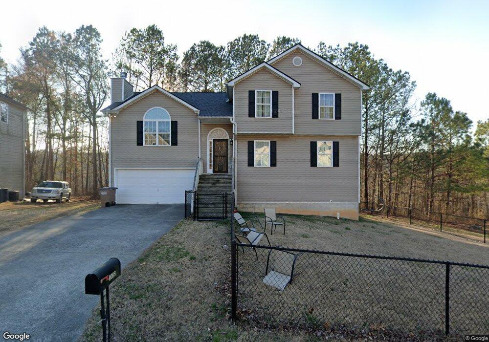
4018 Sydney Cir Dalton, GA 30721
Estimated Value: $257,785 - $305,000
3
Beds
2
Baths
1,308
Sq Ft
$219/Sq Ft
Est. Value
About This Home
This home is located at 4018 Sydney Cir, Dalton, GA 30721 and is currently estimated at $286,196, approximately $218 per square foot. 4018 Sydney Cir is a home located in Whitfield County with nearby schools including Pleasant Grove Elementary School, New Hope Middle School, and Northwest Whitfield County High School.
Ownership History
Date
Name
Owned For
Owner Type
Purchase Details
Closed on
Jul 7, 2008
Sold by
Not Provided
Bought by
Hensley Grady E and Hensley Lori A
Current Estimated Value
Purchase Details
Closed on
Mar 23, 2007
Sold by
Navajo Construction Inc
Bought by
Hensley Grady E
Home Financials for this Owner
Home Financials are based on the most recent Mortgage that was taken out on this home.
Original Mortgage
$142,900
Interest Rate
6.18%
Mortgage Type
New Conventional
Purchase Details
Closed on
Dec 13, 2005
Sold by
Not Provided
Bought by
Hensley Grady E and Hensley Lori A
Purchase Details
Closed on
Mar 4, 2003
Sold by
Blochinger Neal
Bought by
Crescent Bank & Trust Co
Purchase Details
Closed on
Jan 31, 2000
Sold by
Mcbrayer W Earl Etal
Bought by
Blochinger Neal
Create a Home Valuation Report for This Property
The Home Valuation Report is an in-depth analysis detailing your home's value as well as a comparison with similar homes in the area
Home Values in the Area
Average Home Value in this Area
Purchase History
| Date | Buyer | Sale Price | Title Company |
|---|---|---|---|
| Hensley Grady E | -- | -- | |
| Hensley Grady E | $142,900 | -- | |
| Hensley Grady E | $243,000 | -- | |
| Crescent Bank & Trust Co | -- | -- | |
| Blochinger Neal | $297,400 | -- |
Source: Public Records
Mortgage History
| Date | Status | Borrower | Loan Amount |
|---|---|---|---|
| Previous Owner | Hensley Grady E | $142,900 |
Source: Public Records
Tax History Compared to Growth
Tax History
| Year | Tax Paid | Tax Assessment Tax Assessment Total Assessment is a certain percentage of the fair market value that is determined by local assessors to be the total taxable value of land and additions on the property. | Land | Improvement |
|---|---|---|---|---|
| 2024 | $2,314 | $108,442 | $14,000 | $94,442 |
| 2023 | $2,314 | $83,969 | $14,000 | $69,969 |
| 2022 | $1,487 | $58,968 | $9,600 | $49,368 |
| 2021 | $1,487 | $58,968 | $9,600 | $49,368 |
| 2020 | $1,526 | $58,968 | $9,600 | $49,368 |
| 2019 | $1,546 | $58,968 | $9,600 | $49,368 |
| 2018 | $1,332 | $51,563 | $9,600 | $41,963 |
| 2017 | $1,333 | $51,563 | $9,600 | $41,963 |
| 2016 | $1,124 | $45,936 | $7,770 | $38,166 |
| 2014 | $901 | $40,847 | $7,770 | $33,077 |
| 2013 | -- | $40,846 | $7,770 | $33,076 |
Source: Public Records
Map
Nearby Homes
- 213 Grassdale Rd
- 486 Haig Mill Rd
- 110 Pinewood Way
- 503 Moore Dr
- 000 Reed Rd
- 1903 Summit View Dr
- 1903 Middle Summit Dr
- 522 Westbrook Rd
- 439 Westbrook Rd
- 1247 Reed Rd
- 1899 Middle Summit Dr Unit 98
- 2215 Kerr Rd NW
- 1899 N Summit Dr Unit 66
- 2256 Waring Rd NW
- 192 Carly Dr
- 1709 Willow Oak Ln Unit 53
- 1706 Chestnut Oak Dr Unit 90
- 407 Quillian Rd
- 117 Pleasant Hill Dr
- 1702 Chestnut Oak Dr
- 4014 Sydney Cir
- 4022 Sydney Cir
- 4010 Sydney Cir
- 4026 Sydney Cir
- 4027 Sydney Cir
- 4013 Sydney Cir
- 4017 Sydney Cir
- 4008 Sydney Cir
- 4009 Sydney Cir
- 4030 Sydney Cir
- 4035 Sydney Cir
- 0 Sydney Cir
- 4006 Sydney Cir
- 4005 Sydney Cir
- 4039 Sydney Cir
- 00 Luke Powell Rd NW
- 2009 Freeport Rd NW
- 0 Freeport Rd NW Unit 114404
- 0 Freeport Rd NW Unit 8473465
- 0 Freeport Rd NW