Estimated Value: $178,000 - $193,000
3
Beds
2
Baths
1,457
Sq Ft
$128/Sq Ft
Est. Value
About This Home
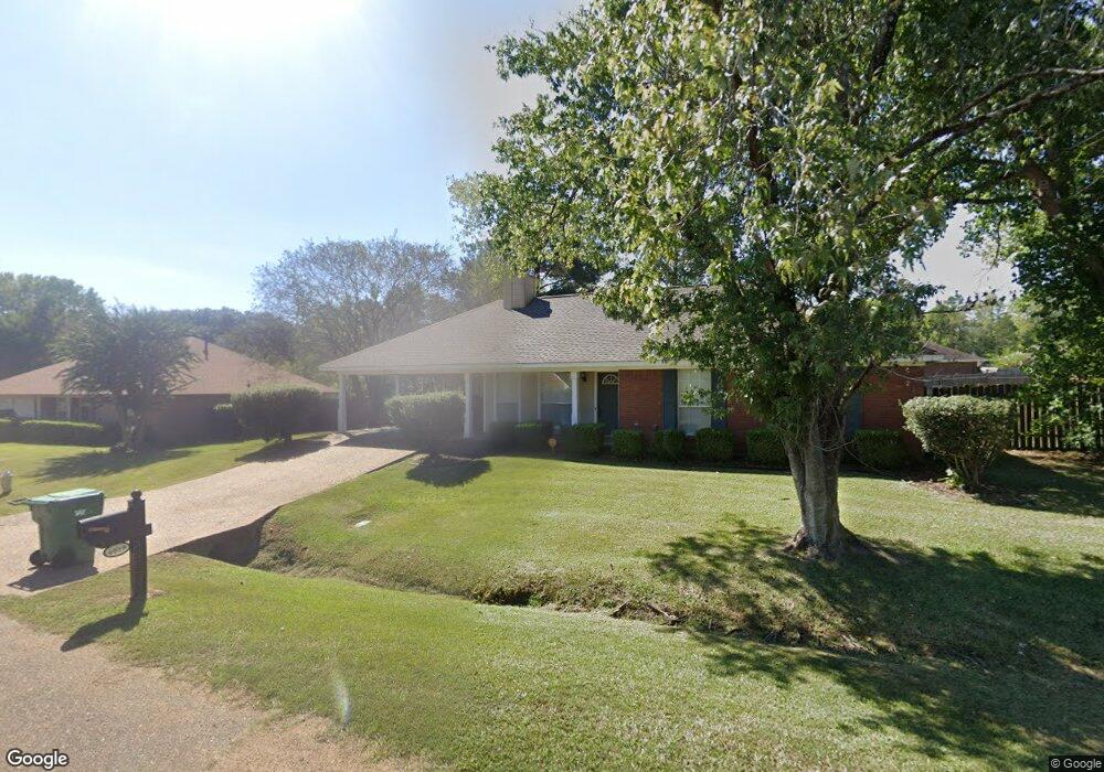
This home is located at 4019 Glennoak Dr, Byram, MS 39272 and is currently estimated at $186,851, approximately $128 per square foot. 4019 Glennoak Dr is a home located in Hinds County with nearby schools including Gary Road Elementary School, Gary Road Intermediate School, and Byram Middle School.
Ownership History
Date
Name
Owned For
Owner Type
Purchase Details
Closed on
Apr 30, 2019
Sold by
Densen Racolesha R and Densen Frederick D
Bought by
Reed April M
Current Estimated Value
Home Financials for this Owner
Home Financials are based on the most recent Mortgage that was taken out on this home.
Original Mortgage
$7,000
Outstanding Balance
$2,896
Interest Rate
4%
Mortgage Type
Second Mortgage Made To Cover Down Payment
Estimated Equity
$183,955
Purchase Details
Closed on
Nov 18, 2009
Sold by
Dace Patrina Robinson and Dace Glen W
Bought by
Denson Racolesha R
Home Financials for this Owner
Home Financials are based on the most recent Mortgage that was taken out on this home.
Original Mortgage
$119,387
Interest Rate
4.92%
Create a Home Valuation Report for This Property
The Home Valuation Report is an in-depth analysis detailing your home's value as well as a comparison with similar homes in the area
Home Values in the Area
Average Home Value in this Area
Purchase History
| Date | Buyer | Sale Price | Title Company |
|---|---|---|---|
| Reed April M | -- | -- | |
| Denson Racolesha R | -- | -- |
Source: Public Records
Mortgage History
| Date | Status | Borrower | Loan Amount |
|---|---|---|---|
| Open | Reed April M | $7,000 | |
| Open | Reed April M | $115,766 | |
| Previous Owner | Denson Racolesha R | $119,387 |
Source: Public Records
Tax History Compared to Growth
Tax History
| Year | Tax Paid | Tax Assessment Tax Assessment Total Assessment is a certain percentage of the fair market value that is determined by local assessors to be the total taxable value of land and additions on the property. | Land | Improvement |
|---|---|---|---|---|
| 2025 | $1,007 | $8,353 | $2,500 | $5,853 |
| 2024 | $1,007 | $8,353 | $2,500 | $5,853 |
| 2023 | $1,007 | $8,353 | $2,500 | $5,853 |
| 2022 | $1,285 | $8,353 | $2,500 | $5,853 |
| 2021 | $968 | $8,353 | $2,500 | $5,853 |
| 2020 | $938 | $8,259 | $2,500 | $5,759 |
| 2019 | $931 | $8,259 | $2,500 | $5,759 |
| 2018 | $931 | $8,259 | $2,500 | $5,759 |
| 2017 | $909 | $8,259 | $2,500 | $5,759 |
| 2016 | $909 | $8,259 | $2,500 | $5,759 |
| 2015 | $898 | $8,183 | $2,500 | $5,683 |
| 2014 | $881 | $8,183 | $2,500 | $5,683 |
Source: Public Records
Map
Nearby Homes
- 2120 Meagan Dr
- Cali Plan at Cedars of Byram Estates
- Aria Plan at Cedars of Byram Estates
- 909 Eagles Nest Dr
- 1213 Lake Shore Dr
- 880 Redwood Cove
- 38 Stacy Cove
- 109 Lucas Ct
- 104 Lucas Ct
- 85 Susan Cove
- 8834 Gary Rd
- 344 Brannan Ave
- 213 Longfellow Cove
- 368 Brannon Ave
- 0 Terry Rd Unit 21325508
- 0 Terry Rd Unit 24270230
- 0 Terry Rd Unit 4130083
- 804 Fairway Ave
- 800 Fairway Ave
- 608 Carson Dr
- 4019 Glenn Oak Dr
- 4015 Glennoak Dr
- 4015 Glenn Oak Dr
- 4263 Glennoak Cir
- 4022 Glenn Oak Dr
- 4022 Glennoak Dr
- 4279 Glennoak Cir
- 4277 Glennoak Cir
- 4018 Glennoak Dr
- 4281 Glennoak Cir
- 4281 Glenn Oak Cir
- 4026 Glenn Oak Dr
- 4026 Glennoak Dr
- 4014 Glennoak Dr
- 4275 Glennoak Cir
- 4293 Glennoak Cir
- 4030 Glennoak Dr
- 4030 Glenn Oak Dr
- 5012 Cedar Glenn Ct
- 4266 Glennoak Cir