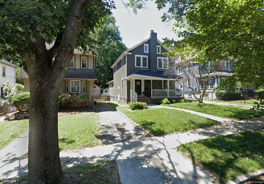
402 Chestnut St Haddonfield, NJ 08033
Estimated Value: $723,707 - $879,000
Studio
--
Bath
2,208
Sq Ft
$376/Sq Ft
Est. Value
About This Home
This home is located at 402 Chestnut St, Haddonfield, NJ 08033 and is currently estimated at $829,927, approximately $375 per square foot. 402 Chestnut St is a home located in Camden County with nearby schools including Haddonfield Memorial High School, Haddonfield Friends School, and Christ the King Regional School.
Ownership History
Date
Name
Owned For
Owner Type
Purchase Details
Closed on
Jul 15, 1994
Sold by
Rosen Howard G
Bought by
Arruda Albert B and Arruda Gail E
Current Estimated Value
Home Financials for this Owner
Home Financials are based on the most recent Mortgage that was taken out on this home.
Original Mortgage
$14,000
Interest Rate
8.25%
Create a Home Valuation Report for This Property
The Home Valuation Report is an in-depth analysis detailing your home's value as well as a comparison with similar homes in the area
Home Values in the Area
Average Home Value in this Area
Purchase History
| Date | Buyer | Sale Price | Title Company |
|---|---|---|---|
| Arruda Albert B | $173,000 | -- |
Source: Public Records
Mortgage History
| Date | Status | Borrower | Loan Amount |
|---|---|---|---|
| Closed | Arruda Albert B | $14,000 |
Source: Public Records
Tax History
| Year | Tax Paid | Tax Assessment Tax Assessment Total Assessment is a certain percentage of the fair market value that is determined by local assessors to be the total taxable value of land and additions on the property. | Land | Improvement |
|---|---|---|---|---|
| 2025 | $13,069 | $404,500 | $157,800 | $246,700 |
| 2024 | $12,895 | $404,500 | $157,800 | $246,700 |
| 2023 | $12,895 | $404,500 | $157,800 | $246,700 |
| 2022 | $12,794 | $404,500 | $157,800 | $246,700 |
| 2021 | $9,569 | $404,500 | $157,800 | $246,700 |
| 2020 | $12,641 | $404,500 | $157,800 | $246,700 |
| 2019 | $125 | $404,500 | $157,800 | $246,700 |
| 2018 | $12,390 | $404,500 | $157,800 | $246,700 |
| 2017 | $12,095 | $404,500 | $157,800 | $246,700 |
| 2016 | $11,514 | $393,900 | $157,800 | $236,100 |
| 2015 | $11,195 | $393,900 | $157,800 | $236,100 |
| 2014 | $10,946 | $393,900 | $157,800 | $236,100 |
Source: Public Records
Map
Nearby Homes
- 121 Reillywood Ave
- 109 S Atlantic Ave
- 125 W Cottage Ave
- 127 W Cottage Ave
- 107 Centre St
- 104 Treaty Elm Ln
- 414 Tavistock
- 139 Treaty Elm Ln
- 301 Tavistock
- 204 Tavistock
- 381 Tavistock
- 133 Tavistock
- 290 Tavistock
- 166 Ellis St
- 110 Potter St
- 60 Potter St
- 33 Estaugh Ave
- 35 Estaugh Ave
- 32 Potter St
- 30 Potter St
- 404 Chestnut St
- 400 Chestnut St
- 406 Chestnut St
- 408 Chestnut St
- 4 E Summit Ave
- 328 Chestnut St
- 403 Chestnut St
- 405 Chestnut St
- 324 Chestnut St
- 101 Reillywood Ave
- 327 S Atlantic Ave
- 401 Chestnut St
- 319 Chestnut St
- 320 Chestnut St
- 321 S Atlantic Ave
- 315 Chestnut St
- 107 Reillywood Ave
- 313 S Atlantic Ave
- 313 Chestnut St
- 316 Chestnut St
Your Personal Tour Guide
Ask me questions while you tour the home.