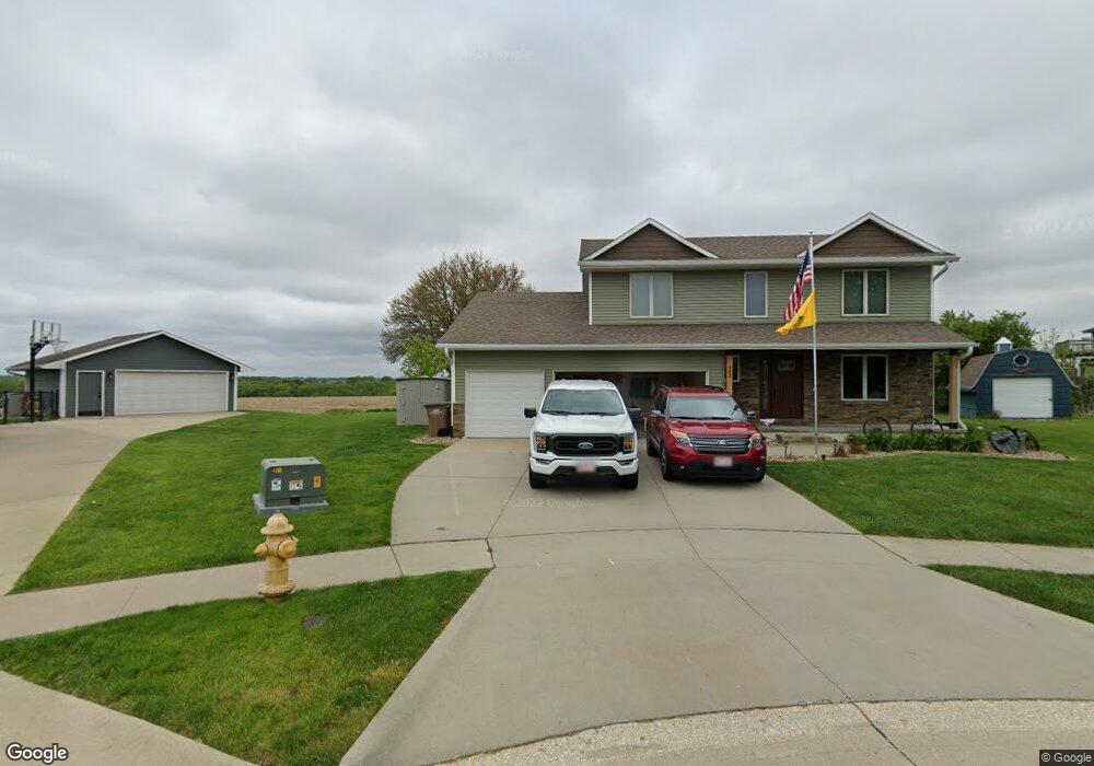
402 Maple Ct Runnells, IA 50237
Estimated Value: $301,000 - $341,000
3
Beds
3
Baths
2,009
Sq Ft
$160/Sq Ft
Est. Value
About This Home
This home is located at 402 Maple Ct, Runnells, IA 50237 and is currently estimated at $321,234, approximately $159 per square foot. 402 Maple Ct is a home located in Polk County with nearby schools including Runnells Elementary School, Southeast Polk Spring Creek- 6th Grade, and Southeast Polk Junior High School.
Ownership History
Date
Name
Owned For
Owner Type
Purchase Details
Closed on
Oct 13, 2015
Sold by
Sunvold Shawn J and Sunvold Susan Kv
Bought by
Lefler Blaine C and Lefler Jillana L
Current Estimated Value
Home Financials for this Owner
Home Financials are based on the most recent Mortgage that was taken out on this home.
Original Mortgage
$186,067
Outstanding Balance
$144,066
Interest Rate
3.5%
Mortgage Type
FHA
Estimated Equity
$177,168
Purchase Details
Closed on
Apr 1, 2003
Sold by
Harvey Christopher L and Harvey Jennifer L
Bought by
Sunvold Shawn J and Sunvold Susan K
Home Financials for this Owner
Home Financials are based on the most recent Mortgage that was taken out on this home.
Original Mortgage
$148,000
Interest Rate
5.76%
Create a Home Valuation Report for This Property
The Home Valuation Report is an in-depth analysis detailing your home's value as well as a comparison with similar homes in the area
Purchase History
| Date | Buyer | Sale Price | Title Company |
|---|---|---|---|
| Lefler Blaine C | $189,500 | None Available | |
| Sunvold Shawn J | $184,500 | -- |
Source: Public Records
Mortgage History
| Date | Status | Borrower | Loan Amount |
|---|---|---|---|
| Open | Lefler Blaine C | $186,067 | |
| Previous Owner | Sunvold Shawn J | $148,000 | |
| Closed | Sunvold Shawn J | $27,750 |
Source: Public Records
Tax History
| Year | Tax Paid | Tax Assessment Tax Assessment Total Assessment is a certain percentage of the fair market value that is determined by local assessors to be the total taxable value of land and additions on the property. | Land | Improvement |
|---|---|---|---|---|
| 2025 | $4,786 | $313,100 | $36,700 | $276,400 |
| 2024 | $4,786 | $283,600 | $32,400 | $251,200 |
| 2023 | $4,542 | $283,600 | $32,400 | $251,200 |
| 2022 | $4,484 | $235,900 | $28,000 | $207,900 |
| 2021 | $4,206 | $235,900 | $28,000 | $207,900 |
| 2020 | $4,134 | $211,800 | $25,100 | $186,700 |
| 2019 | $4,004 | $211,800 | $25,100 | $186,700 |
| 2018 | $4,010 | $191,200 | $22,000 | $169,200 |
| 2017 | $4,132 | $191,200 | $22,000 | $169,200 |
| 2016 | $4,112 | $177,100 | $20,200 | $156,900 |
| 2015 | $4,112 | $177,100 | $20,200 | $156,900 |
| 2014 | $5,010 | $212,600 | $19,500 | $193,100 |
Source: Public Records
Map
Nearby Homes
- 303 W Mckinney St
- 203 Brown St
- 12028 SE 64th Ave
- 3333 220th Ave
- 3380 SE 96th St
- 2493 SE 108th St
- 2360 SE 108th St
- 0 S 128th Ave W
- 10579 W 129th St S
- 410 N Vine St
- 1462 108th St SE
- 7930 SE Vandalia Dr
- 2456 SE 88th St
- 7820 SE Vandalia Dr
- 3350 SE 82nd St
- 24479 Elthon Place
- 2496 SE 83rd Ct
- 3356 SE 82nd St
- 2511 SE 82nd St
- 5825 G24 Hwy
Your Personal Tour Guide
Ask me questions while you tour the home.