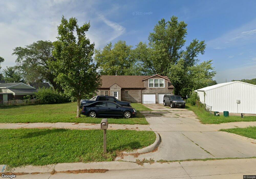
402 N Center Point Rd Hiawatha, IA 52233
Estimated Value: $205,000 - $218,000
2
Beds
2
Baths
1,670
Sq Ft
$126/Sq Ft
Est. Value
About This Home
This home is located at 402 N Center Point Rd, Hiawatha, IA 52233 and is currently estimated at $211,181, approximately $126 per square foot. 402 N Center Point Rd is a home located in Linn County with nearby schools including T.C. Cherry Elementary School, Nixon Elementary School, and Ponderosa Elementary School.
Ownership History
Date
Name
Owned For
Owner Type
Purchase Details
Closed on
Oct 6, 2010
Sold by
King Jeri
Bought by
King John W
Current Estimated Value
Purchase Details
Closed on
Feb 22, 2005
Sold by
Speight Jeffrey A and Speight Becky R
Bought by
King John W and King Jeri
Home Financials for this Owner
Home Financials are based on the most recent Mortgage that was taken out on this home.
Original Mortgage
$107,793
Outstanding Balance
$54,645
Interest Rate
5.71%
Mortgage Type
FHA
Estimated Equity
$156,536
Purchase Details
Closed on
Apr 22, 1999
Sold by
Thomas Barnes and Thomas Robert N
Bought by
Speight Jeffrey A and Speight Becky R
Home Financials for this Owner
Home Financials are based on the most recent Mortgage that was taken out on this home.
Original Mortgage
$70,000
Interest Rate
7.17%
Create a Home Valuation Report for This Property
The Home Valuation Report is an in-depth analysis detailing your home's value as well as a comparison with similar homes in the area
Home Values in the Area
Average Home Value in this Area
Purchase History
| Date | Buyer | Sale Price | Title Company |
|---|---|---|---|
| King John W | -- | None Available | |
| King John W | $117,500 | -- | |
| Speight Jeffrey A | $89,500 | -- |
Source: Public Records
Mortgage History
| Date | Status | Borrower | Loan Amount |
|---|---|---|---|
| Open | King John W | $107,793 | |
| Previous Owner | Speight Jeffrey A | $70,000 |
Source: Public Records
Tax History Compared to Growth
Tax History
| Year | Tax Paid | Tax Assessment Tax Assessment Total Assessment is a certain percentage of the fair market value that is determined by local assessors to be the total taxable value of land and additions on the property. | Land | Improvement |
|---|---|---|---|---|
| 2025 | $2,734 | $217,700 | $25,500 | $192,200 |
| 2024 | $2,708 | $185,400 | $25,500 | $159,900 |
| 2023 | $2,708 | $185,400 | $25,500 | $159,900 |
| 2022 | $2,672 | $145,800 | $25,500 | $120,300 |
| 2021 | $2,686 | $145,800 | $25,500 | $120,300 |
| 2020 | $2,686 | $137,200 | $25,500 | $111,700 |
| 2019 | $2,496 | $128,800 | $25,500 | $103,300 |
| 2018 | $2,446 | $128,800 | $25,500 | $103,300 |
| 2017 | $2,536 | $127,700 | $25,500 | $102,200 |
| 2016 | $2,656 | $127,700 | $25,500 | $102,200 |
| 2015 | $2,662 | $127,700 | $25,500 | $102,200 |
| 2014 | $2,476 | $127,700 | $25,500 | $102,200 |
| 2013 | $2,404 | $127,700 | $25,500 | $102,200 |
Source: Public Records
Map
Nearby Homes
- 3 N Center Point Rd
- 1 N Center Point Rd
- 105 W Willman St
- 5455 Blairs Ferry Rd NE
- 109 E Willman St
- 114 Northwood Dr
- 250 Cimarron Dr Unit 311
- 780 Ryan Ave
- 6505 Brookview Ln NE
- 306 10th Ave
- 1213 Raney St
- 1355 Robins Rd
- 1213 Bowler St
- 1364 Cress Pkwy
- 0 Council St NE
- 4761 Westchester Dr NE Unit C
- 2838 Anne Dr
- 2596 Anne Ln
- 4609 White Pine Dr NE
- 1472 Tower Ln NE Unit 5
- 400 N Center Point Rd
- 104 Fisher St
- 106 Fisher St
- 108 Fisher St
- 102 Fisher St
- 406 N Center Point Rd
- 110 Fisher St
- 111 N Center Point Rd Unit B
- 105 Fisher St
- 107 Fisher St
- 109 N Center Point Rd
- 103 Fisher St
- 109 Fisher St
- 105 N Center Point Rd
- 107 N Center Point Rd
- 111 Fisher St
- 101 Fisher St
- 101 N Center Point Rd
- 500 N Center Point Rd
- 104 Emmons St